


Visualizing Your Perfect Run: Exploring Ski Resorts with the TESTPLAY 3D Map Experience
Imagine standing at the top of a mountain, not just with a paper map that flattens complex terrain into two dimensions, but with a dynamic, immersive guide that shows you every contour, every tree line, and the exact pitch of the slope ahead. Traditional ski maps have served us for decades, providing essential information about lifts, runs, and basic resort layout. However, they often fall short in conveying the true feel and complexity of mountainous environments, leaving skiers guessing about conditions, hidden hazards, and the best route for their specific skill level or desired experience.
This lack of detailed, intuitive visualization can impact everything from pre-trip planning and on-mountain navigation to safety and overall enjoyment. Skiers might miss hidden gems, take unintended difficult routes, or struggle to orient themselves in vast, unfamiliar terrain. For ski resorts, this translates to potential visitor frustration, challenges in communicating real-time information effectively, and limitations in operational planning and emergency response.
Fortunately, a new era in ski resort visualization is here, offering a powerful solution to these long-standing challenges. The TESTPLAY 3D Map Experience represents a significant leap forward, transforming static resort data into an interactive, lifelike digital environment. This authoritative blog post will delve deep into what the TESTPLAY 3D Map Experience is, the technology that powers it, and how it is revolutionizing the ski experience for both enthusiastic skiers and the resorts that host them. We will explore its myriad benefits, from enhancing route planning and safety for individuals to streamlining operations and elevating marketing for resorts, demonstrating why this innovative platform is poised to become an indispensable tool in the world of skiing.
The Limitations of Traditional Ski Maps: A Flat Reality
For generations, the standard paper trail map has been the trusted companion of skiers. These maps provide a schematic overview, outlining the network of lifts, designated runs, and key facilities like lodges and restrooms. They use color-coding to indicate run difficulty and symbols for amenities.
While functional at a basic level, these traditional maps have inherent limitations rooted in their two-dimensional format. Mountains are anything but flat; they are complex geological formations with varying slopes, sudden drops, hidden gullies, and undulating terrain that is difficult, if not impossible, to accurately represent on a flat surface. This lack of true perspective makes it challenging for skiers to judge distances, predict the steepness of a slope based solely on contour lines they may not fully understand, or visualize the actual layout of a run before they are on it.
Understanding spatial relationships – how one run connects to another, where exactly that restaurant is in relation to your current position, or the quickest way back to the base lodge – can be surprisingly difficult with a traditional map. The simplified graphical representation often sacrifices detail and nuance for clarity, sometimes leading to confusion rather than confidence. Furthermore, traditional maps are static; they cannot display real-time information crucial for a dynamic mountain environment, such as current snow conditions on a specific run, which lifts are open or closed due to weather or maintenance, or updated wait times.
In essence, traditional ski maps offer a top-down, generalized view that lacks the immersive detail needed for truly informed decision-making on the mountain. They are a necessary tool, but one constrained by the limitations of their medium, leaving a significant gap in how skiers can visualize, plan, and experience a resort's terrain in a truly intuitive way. This is the gap that the TESTPLAY 3D Map Experience is specifically designed to fill, offering a dynamic and accurate representation that goes far beyond the capabilities of its paper predecessors.
Introducing the TESTPLAY 3D Map Experience: A New Dimension
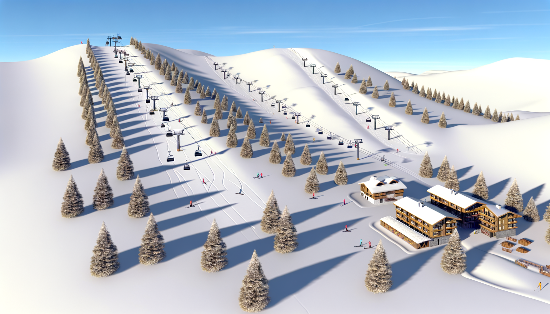
The TESTPLAY 3D Map Experience is not merely a digital version of a paper map; it is a sophisticated, interactive visualization platform that recreates ski resorts in stunning three dimensions. It takes complex topographical data and transforms it into an intuitive, navigable environment that users can explore from any angle, gaining a true sense of the terrain's scale, shape, and features. This platform is designed to bridge the gap between schematic representation and real-world perception, providing skiers and resort operators alike with an unprecedented level of detail and interactivity.
Think of it as a high-fidelity digital twin of the ski resort, complete with accurate representations of slopes, lifts, buildings, and natural elements like trees and rocks. Users can fly through the resort, zoom in on specific areas, and view the terrain from various perspectives, such as a bird's-eye view or even a simulated skier's-eye view down a run. This level of immersive detail allows for a much deeper understanding of the resort's layout and topography than any traditional map could ever provide.
The core purpose of the TESTPLAY 3D Map Experience is to provide clarity, enhance planning, and improve safety by offering a realistic and dynamic representation of the ski environment. It integrates various layers of information, going beyond just showing runs and lifts to potentially incorporating real-time data feeds, points of interest, and safety markers. This comprehensive approach makes it an invaluable tool throughout the entire ski journey, from the initial planning stages at home to navigating the slopes on the mountain itself.
Core Technology Explained: Building the Digital Mountain
The creation of the TESTPLAY 3D Map Experience relies on sophisticated data acquisition and processing technologies. The foundation is typically built upon high-resolution topographical data, often captured using advanced techniques like LiDAR (Light Detection and Ranging) and aerial photogrammetry. These methods precisely measure the earth's surface, capturing minute details of elevation, slope, and terrain features with remarkable accuracy.
This raw topographical data is then combined with other relevant datasets, including satellite imagery, detailed ground-level photographs, and Geographical Information System (GIS) data provided by the ski resort. GIS data includes the exact locations and attributes of runs (difficulty, name, grooming status), lifts (type, status, capacity), buildings, facilities, boundaries, and designated safety zones. This integration is crucial for accurately overlaying resort infrastructure onto the realistic 3D terrain model.
The collected data undergoes a complex processing pipeline. Specialized software stitches together aerial and ground imagery, aligns it perfectly with the topographical model, and reconstructs the environment in three dimensions. This process requires significant computational power and sophisticated algorithms to create a seamless, detailed, and geometrically accurate digital representation of the resort. The result is a highly detailed 3D model where every slope angle, turn, and feature is rendered with precision, offering a level of realism previously unattainable in digital ski mapping.
A New Dimension of Detail: Seeing is Believing
What truly sets the TESTPLAY 3D Map Experience apart is the unparalleled level of visual detail it offers. It moves beyond the abstract lines and symbols of traditional maps to provide a rich, realistic depiction of the ski environment. Users can see the subtle rolls and dips in the terrain, the density of tree islands, the exact path of a winding cat track, and the precise location and structure of every lift tower and building.
The accuracy extends to the slope angles themselves. Instead of relying solely on color-coded difficulty ratings (which can vary between resorts and don't tell the whole story), users can visually inspect the pitch of a run in 3D, gaining a much better sense of its true challenge. This visual representation makes it easier to understand why a 'blue' run might feel different at different resorts or how a 'black' run varies in steepness from top to bottom.
Crucially, the platform can integrate real-time data overlays, adding layers of dynamic information onto the static 3D model. This includes displaying which runs and lifts are currently open or closed, highlighting areas with recent grooming, indicating locations of hazards or slow zones, showing current weather conditions, and even potentially providing real-time wait times at lifts. This ability to combine static, accurate topography with dynamic, up-to-the-minute information creates an incredibly powerful tool for planning and navigation on the mountain.
Unlocking Benefits for Skiers: Enhance Your Adventure
The TESTPLAY 3D Map Experience brings a wealth of tangible benefits directly to the skier, transforming the way they interact with a resort and enhancing their overall mountain adventure. It empowers individuals with better information, leading to more confident exploration and a more enjoyable day on the slopes. The intuitive 3D visualization eliminates much of the guesswork associated with traditional maps.
Enhanced Route Planning and Navigation: Ski Smarter
One of the most significant advantages for skiers is the ability to plan routes with unprecedented insight and navigate the resort more effectively. Before even leaving the lodge or their accommodation, skiers can explore the entire resort in 3D, visualizing potential paths down the mountain. They can see how different runs connect, identify key junctions, and understand the flow of terrain in a way that is impossible with a flat map.
Planning a multi-run itinerary becomes a more intuitive process. Skiers can visually preview the terrain of a specific run, assess its difficulty based on its apparent steepness and features, and link together multiple runs and lifts to create a customized plan tailored to their skill level and preferences. On the mountain, the 3D map acts as a dynamic GPS, showing the skier's precise location within the realistic 3D environment. This makes it incredibly easy to orient oneself, confirm they are on the intended run, and find points of interest like restaurants, restrooms, or meeting points.
Getting lost or taking a wrong turn onto an unexpectedly challenging run becomes far less likely. The ability to see the terrain clearly aids in choosing appropriate runs and navigating confidently from one part of the resort to another. This leads to less time spent fumbling with a map and more time enjoying the ride, making the ski day smoother and more fulfilling.
Improved Safety and Awareness: Ski Safer
Safety on the mountain is paramount, and the TESTPLAY 3D Map Experience significantly enhances skier awareness and contributes to safer practices. By providing a highly accurate and detailed representation of the terrain, it helps skiers identify potential hazards that might not be apparent on a traditional map. This could include hidden drops, narrow passages, steep sections, or areas prone to wind loading or ice formation, especially if integrated with real-time condition data.
The precise visualization allows skiers to better understand the environment around them, making more informed decisions about where and how to ski. They can visualize the terrain before committing to a run, assessing risks based on the realistic 3D rendering. In emergencies, the ability to quickly and accurately pinpoint one's location on the 3D map can be critical for communicating with ski patrol or rescue services. Showing exactly where they are on a recognizable, realistic model is far more effective than trying to describe a position based on abstract map lines.
Furthermore, if integrated with resort safety information, the map can highlight slow zones, closed areas, or avalanche danger areas with clear visual markers on the 3D terrain. This proactive communication of safety-critical information directly within the navigable map environment helps skiers stay informed and make responsible choices, ultimately contributing to a safer experience for everyone on the mountain. It's about providing the tools for skiers to be more self-sufficient and aware of their surroundings.
Immersive Pre-Trip Visualization: Build Anticipation
The ski experience begins long before you arrive at the resort. Planning a trip, especially to a new destination, involves researching the terrain and picturing yourself on the slopes. Traditional research methods, like looking at flat maps and photos, can only go so far in building a true sense of place.
The TESTPLAY 3D Map Experience offers an incredibly immersive way to explore a resort from the comfort of your home. Prospective visitors can take virtual tours, fly over runs, and get a feel for the resort's layout and the scale of the mountain. This pre-trip visualization is not only practical for planning which runs to tackle but also incredibly effective at building excitement and anticipation for the upcoming trip. Users can virtually explore the base area, locate specific lifts and facilities, and even preview views from different parts of the mountain.
This immersive exploration helps skiers arrive feeling more familiar and confident with the resort layout, reducing that initial period of disorientation sometimes experienced at a new destination. It allows them to make better choices about which areas of the resort they want to focus on based on a realistic understanding of the terrain. Essentially, it provides a powerful tool for getting acquainted with a resort before you ever click into your bindings, making the transition from planning to skiing seamless and informed.
Transforming Operations for Ski Resorts: Enhance Efficiency and Appeal
Beyond the direct benefits to skiers, the TESTPLAY 3D Map Experience offers significant advantages for the ski resorts themselves. It provides a powerful new tool for marketing, operational management, safety planning, and enhancing the overall visitor experience. Resorts can leverage the detailed 3D model to improve communication, streamline processes, and gain valuable insights.
Elevated Marketing and Visitor Experience: Attract and Delight Guests
In a competitive market, ski resorts are constantly looking for innovative ways to attract visitors and enhance their experience. The TESTPLAY 3D Map provides a unique and highly engaging marketing asset. Resorts can embed the interactive 3D map on their websites and mobile apps, offering potential visitors an unprecedented virtual tour and exploration capability. This immersive experience can be a significant differentiator, showcasing the resort's terrain and amenities in a far more compelling way than static images or flat maps.
Once visitors are at the resort, the 3D map enhances their experience by providing intuitive, real-time navigation and information. Easy access to accurate information about open runs, lift statuses, and points of interest within a realistic visual context reduces frustration and helps guests make the most of their time on the mountain. Resorts can use the platform to highlight special events, recommended routes, or scenic viewpoints, guiding visitors to areas they might otherwise miss.
Providing a superior digital experience reflects positively on the resort's brand image, positioning it as modern, guest-focused, and technologically advanced. This enhanced digital interaction contributes significantly to overall guest satisfaction and encourages return visits. The ability to explore and navigate the resort seamlessly in 3D makes the entire experience feel more intuitive and less intimidating, especially for new visitors or those exploring different sections of a large resort.
Streamlined Safety Management and Planning: Operational Excellence
Operational efficiency and safety management are critical aspects of running a ski resort. The TESTPLAY 3D Map Experience provides powerful tools that can support these functions. For safety teams and ski patrol, the accurate 3D model offers an unparalleled view of the terrain, aiding in planning rescue operations, identifying potential avalanche zones (when integrated with specific data), and strategically positioning personnel or resources.
Visualizing potential routes for accessing remote areas during an emergency, or understanding the challenging topography of off-piste zones, is significantly easier in 3D. The platform can also be used for planning routine maintenance activities, like snowmaking or grooming, by providing a detailed visual reference of the terrain. Resort management can use the map to plan and visualize changes to run boundaries, lift lines, or new facility locations with greater accuracy than traditional methods allow.
Communicating real-time operational status – such as closed runs or lifts, slow zones, or maintenance areas – is more effective when displayed directly on the interactive 3D map. This clear visual communication helps both staff and guests stay informed, contributing to a safer and more smoothly running operation. The ability to visualize the entire resort environment accurately supports better decision-making across various operational departments, from snow safety to guest services.
Data-Driven Insights and Future Development: Planning for Growth
The digital nature of the TESTPLAY 3D Map Experience opens up possibilities for collecting and analyzing data to gain valuable insights into resort usage and guest behavior. While respecting privacy, aggregated and anonymized data about which runs are most frequently viewed or navigated within the app can provide resorts with insights into skier preferences and traffic flow patterns. This information can inform decisions about trail maintenance, snowmaking priorities, or even future lift placement.
Understanding how guests interact with different parts of the resort virtually can help identify popular zones or areas that are confusing to navigate. This data can be invaluable for long-term planning and development, helping resorts invest in infrastructure or improve signage in areas where it's needed most. Furthermore, the detailed 3D model serves as a robust digital foundation for planning future resort expansions or modifications.
Architects, planners, and engineers can use the accurate 3D terrain data provided by the platform to visualize proposed changes, assess their impact on the environment and ski flow, and communicate plans more effectively to stakeholders. The platform can potentially integrate simulations or modeling, allowing resorts to visualize the effects of different scenarios, such as snow coverage variations or changes in lift capacity. This data-driven approach supports more informed decisions for sustainable growth and continuous improvement of the resort experience.
Beyond the Slopes: Expanding the TESTPLAY Vision
While the primary application discussed is for winter ski resorts, the underlying technology behind the TESTPLAY 3D Map Experience has significant potential for broader applications within mountain environments and beyond. The creation of highly accurate, interactive 3D models of complex terrain is valuable for numerous outdoor recreational and operational uses.
In the summer months, the same 3D model can be adapted to visualize hiking and biking trails, climbing routes, or scenic viewpoints. Users could plan mountain biking descents with a clear understanding of the trail's pitch and features or plan hiking routes based on elevation gain visualized in 3D. This allows resorts to leverage the technology year-round, promoting multi-season activities and enhancing the experience for summer visitors as well.
Other potential applications include using the 3D models for environmental monitoring and planning, visualizing real estate developments within mountain communities, or even supporting search and rescue operations in off-resort areas. The ability to render complex natural environments accurately in a navigable digital format has wide-ranging implications for tourism, land management, and emergency services in mountainous regions. The core capability – transforming detailed topographical data into intuitive, interactive 3D visualization – is a versatile technology with a future far beyond just skiing, positioning TESTPLAY as a leader in digital outdoor mapping.
Experiencing the Future of Skiing Today: Take the Next Step
The TESTPLAY 3D Map Experience represents a paradigm shift in how we interact with ski resorts, moving from static, abstract representations to dynamic, realistic visualizations. It is a technology that empowers skiers with better information for planning and safety and provides resorts with powerful tools for enhancing operations, marketing, and guest satisfaction. The limitations of traditional maps are overcome by a platform that truly allows users to see and understand the mountain environment in an intuitive, immersive way.
For skiers, this means more confident exploration, safer decisions on the slopes, and the ability to plan the perfect ski day tailored precisely to their desires and abilities. For ski resorts, it means attracting more guests, improving operational efficiency, enhancing safety protocols, and gaining valuable insights for future development. It's a win-win scenario that elevates the entire ski ecosystem.
The future of ski resort visualization is here, and it is in stunning three dimensions. The TESTPLAY 3D Map Experience is poised to become an essential tool for anyone who loves to hit the slopes, offering a level of insight and interactivity that will change how you see the mountain forever. Whether you are a seasoned local or planning your first visit to a new resort, experiencing the mountain in 3D will unlock new possibilities and enhance every aspect of your adventure.
To learn more about the TESTPLAY 3D Map Experience or to see examples of how this revolutionary technology is being implemented at leading ski resorts, we encourage you to visit their official website or look for resorts that have already adopted this platform. Discover how visualizing your perfect run in 3D can transform your next ski trip and experience the future of mountain exploration today.