


Beyond Flat Surfaces: Using Raised Relief Maps to Truly Understand Earth's Geography
For centuries, maps have been our indispensable guides to understanding the world. They flatten the vast, complex surface of Earth onto a manageable plane, allowing us to see distances, boundaries, and the relative positions of places.
We rely on them for navigation, planning, and education, and they are foundational tools for geography and many other disciplines. However, while incredibly useful, traditional flat maps present a significant limitation: they struggle to adequately represent the third dimension – elevation.
This makes it challenging for many people, especially students and those new to geographical concepts, to truly grasp the contours, slopes, and textures of the land. How tall are those mountains really, and how steep is their ascent? How does the land undulate between cities? What barriers did ancient explorers or modern infrastructure planners face due to the terrain?
This is where raised relief maps offer a powerful, often overlooked, solution. By adding a tactile, three-dimensional element, these maps transform abstract contour lines and shaded areas into physical landscapes you can see and touch.
They provide an intuitive understanding of topography that a flat map simply cannot replicate, making geographical concepts more concrete, engaging, and memorable.
In this comprehensive guide, we will delve into the world of raised relief maps, exploring what they are, why they are so effective, their diverse applications from education to exploration, and how you can use them to unlock a profoundly deeper understanding of Earth's geography.
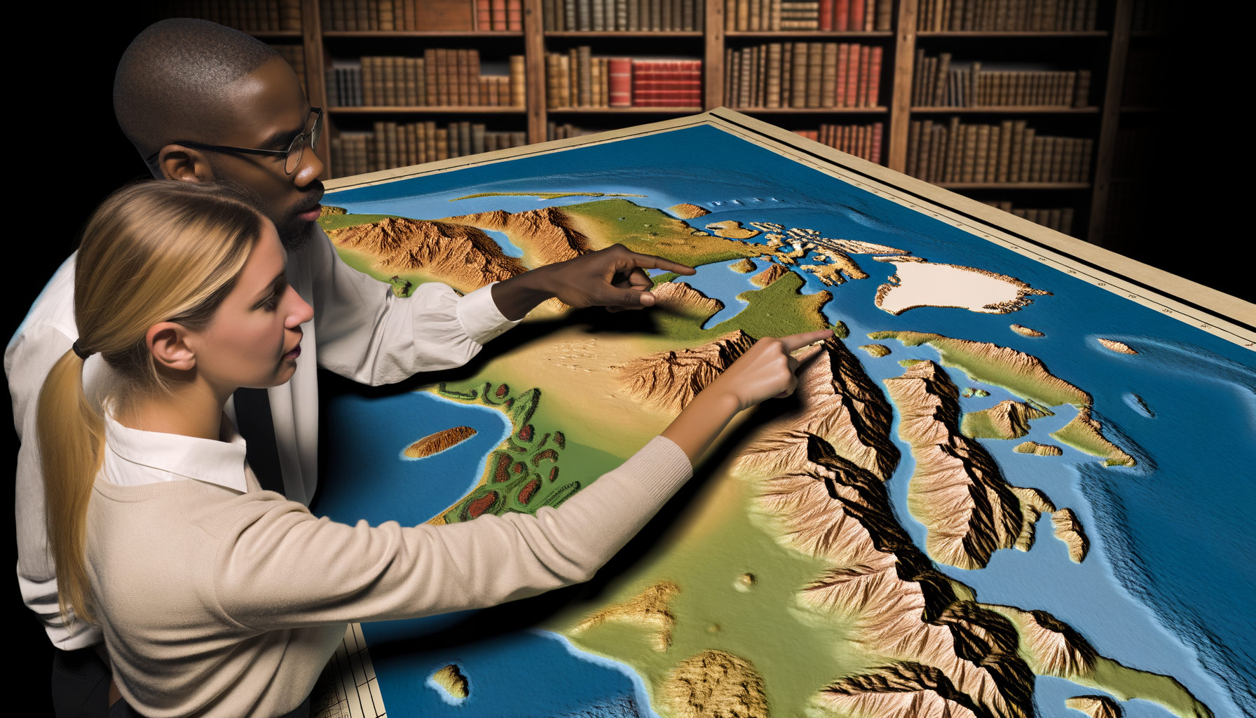
What Exactly Are Raised Relief Maps?
At their core, raised relief maps are topographical maps where the elevation of the land is physically represented by variations in height.
Unlike standard maps that use lines, colors, or shading to *indicate* altitude, these maps use actual three-dimensional molding to depict mountains, valleys, plateaus, and plains as tangible forms.
Think of them as scale models of the Earth's surface, often with vertical exaggeration to make the relief more prominent and easily discernible.
The creation of raised relief maps has evolved over time. Early methods involved hand-sculpting landscapes, a painstaking and often imprecise process.
More commonly in the 20th century, they were produced by printing a topographical map onto a sheet of plastic and then using a vacuum-forming process to mold the heated plastic over a master mold or tool that represents the terrain's shape.
Modern techniques might involve sophisticated computer modeling and fabrication methods, including CNC milling or 3D printing, allowing for even greater accuracy and detail in representing complex geological features.
The key distinguishing feature, regardless of the production method, is the tactile nature. You can run your fingers over mountain ranges, feel the depth of valleys, and trace the path of rivers as they cut through the elevated terrain.
This physical interaction is not just a novelty; it's a fundamental aspect of how raised relief maps enhance our cognitive understanding of geography and topography.
The Limitations of Flat Maps (When Used Alone)
Flat maps are undeniably essential tools. They excel at showing large areas at a glance, displaying political boundaries, transportation networks, and a vast array of data through symbols and colors.
They allow for precise measurement of distance and direction on a two-dimensional plane, which is crucial for many applications.
Cartographers have developed ingenious ways to represent elevation on flat maps, including contour lines, hachures, shaded relief, and hypsometric coloring (using different colors to represent elevation bands).
However, interpreting these representations requires a level of spatial reasoning and abstract thought. Contour lines, for example, show points of equal elevation.
Understanding the *steepness* of a slope requires analyzing how close together these lines are – closely spaced lines mean a steep incline, while widely spaced lines indicate gentle terrain.
While experienced map readers can glean a lot from these symbols, someone new to map reading might find it difficult to translate these abstract lines into a mental image of rolling hills or sheer cliffs.
Furthermore, the sheer scale of elevation changes can be hard to appreciate on a flat surface. A mountain range might look like a series of wavy lines or a blotch of color, but its physical presence as a significant barrier or a dominant landscape feature is often lost.
The feeling of elevation, the effort required to traverse upward, the way water flows downhill – these fundamental aspects of geography are challenging to convey through symbols on a flat page.
This is precisely the gap that raised relief maps fill, offering a complementary perspective that makes the abstract concrete.
The Unmatched Power of Tangibility
One of the most significant advantages of raised relief maps is the sensory experience they offer. Our brains are wired to understand the world through multiple senses, and touch is a powerful pathway for learning and comprehension.
When you can physically feel the rise and fall of the land, geographical concepts move beyond intellectual understanding to become embodied knowledge.
Touching a mountain range on a relief map provides a much stronger sense of its scale and form than simply looking at a brown area on a flat map.
This tactile interaction is particularly beneficial for kinesthetic learners, who process information best through physical activity and direct experience.
They can trace river systems, explore plateaus, and compare the height of different mountain ranges with their hands, making the learning process more engaging and effective.
Even for visual or auditory learners, the addition of the tactile dimension reinforces the information presented visually, creating a richer and more memorable learning experience.
For young students, the ability to touch the land makes geography feel more like exploring a miniature world than studying abstract lines on a page. This engagement can spark curiosity and make learning fun.
For anyone, regardless of age, the tangibility allows for a more intuitive grasp of spatial relationships and the physical reality of the landscape being studied.
It moves map reading from a purely intellectual exercise to a more experiential one.
Visualizing the Third Dimension: Elevation and Topography
While tangibility is a major benefit, the visual clarity of the third dimension is equally important. Raised relief maps immediately show you the shape and form of the land in a way that flat maps struggle to achieve.
You can see the distinct profile of a mountain, the sweeping expanse of a valley, or the dramatic drop-off of an escarpment.
This direct visual representation makes it much easier to understand the relationships between different landforms.
Consider a river system. On a flat map, you see blue lines winding across the landscape. On a raised relief map, you see how those rivers follow the lowest points of the terrain, flowing through valleys and around hills.
You can visualize the drainage basin, the area of land where water collects and flows into that river system, by seeing the surrounding higher ground that directs the water's path.
This provides a much clearer understanding of hydrological processes and how they are dictated by topography.
Understanding elevation also involves understanding *slope* and *aspect* (the direction a slope faces). While contour lines show steepness indirectly, a raised relief map lets you *see* the steepness immediately.
A sheer cliff face on a relief map looks and feels dramatically different from a gently sloping plain. This visual distinction is crucial for understanding everything from erosion patterns to the suitability of land for agriculture or construction.
The map becomes a miniature landscape model, allowing you to analyze features in a way that mimics viewing them from an elevated vantage point in the real world.
Raised Relief Maps in Action: Applications and Benefits
The unique advantages of raised relief maps make them valuable tools in a wide range of settings and for diverse purposes. Their benefits extend far beyond simple visualization, impacting learning, planning, exploration, and accessibility.
Raised relief maps are perhaps most widely recognized for their role in educational settings, from elementary schools through university level. They provide an intuitive entry point into understanding complex geographical concepts for students of all ages.
At the secondary and tertiary levels, raised relief maps become powerful tools for teaching more advanced topics. Geology students can study fault lines, volcanic formations, and erosion patterns in a way that is difficult to grasp from two-dimensional diagrams.
Educators use them for demonstrations, allowing the entire class to see and discuss a feature simultaneously. They are excellent for interactive lessons where students are asked to identify landforms, trace routes, or explain geographical processes using the physical map as a reference.
Anyone who enjoys outdoor activities like hiking, camping, climbing, or even scenic driving can benefit immensely from using raised relief maps. While digital mapping apps and traditional topographic maps are essential for navigation, a relief map provides invaluable context during the planning phase.
For climbers, understanding the three-dimensional form of a mountain or rock face is fundamental, and a relief map can provide a broad overview of the feature's shape and relationship to the surrounding landscape.
In fields such as urban planning, architecture, civil engineering, and environmental management, understanding topography is not just academic; it is critical for practical decision-making. Raised relief maps serve as powerful visualization tools in these professional contexts.
Environmental consultants use relief maps to study erosion potential, predict the movement of pollutants through water systems, and plan restoration projects by understanding the natural flow of water and sediment.
Raised relief maps offer significant benefits for individuals with visual impairments, providing them with a tactile way to understand geographical layouts and landforms. While braille labels can be added for place names, the physical variations in height allow users to explore the landscape through touch.
For someone who cannot see the visual representation on a standard map, the ability to feel the undulation of the land on a relief map provides a unique and invaluable connection to the physical world.In Education
For younger learners, they make geography come alive, turning abstract lessons about continents, countries, and physical features into tangible explorations.
Students can literally get their hands on the landscape they are studying, which helps solidify their understanding of basic terms like mountain, valley, river, lake, and plain.
Environmental science students can analyze watersheds, understand how topography influences ecosystems, and visualize the impact of land use.
History and social studies classes can use them to understand how geography influenced human migration, settlement patterns, trade routes, and military strategies (e.g., the defensible nature of mountain ranges or the importance of river valleys).
They serve as a constant, readily accessible reference point in a classroom, reminding students of the physical reality of the places they are learning about and fostering a deeper connection to the Earth's surface.
For Exploration and Recreation
Before setting out on a hike, consulting a relief map of the area allows you to visualize the terrain you will be traversing. You can see the steepness of the ascents and descents, identify potential challenges posed by the topography, and get a realistic sense of the physical effort required.
This can help you choose appropriate routes and be better prepared for the conditions.
Travelers planning a trip to a new region can use a relief map to gain a preliminary understanding of the landscape – are there major mountain ranges to cross, extensive flat plains, or a complex network of rivers and valleys? This informs packing, transportation choices, and overall expectations for the journey.
It adds another layer of appreciation for the physical environment you will experience firsthand.
In Planning and Development
For example, planners considering a new development can use a relief map to assess the suitability of the land, identify areas prone to flooding (low-lying areas near rivers), visualize drainage patterns, and understand how the proposed development will fit into the existing landscape.
Engineers planning roads, bridges, or pipelines need a clear understanding of the terrain to minimize construction challenges and costs, and a relief map offers an immediate, intuitive view of the obstacles and opportunities presented by the topography.
They are also valuable in site selection for infrastructure like wind farms or communication towers, where elevation and exposure to wind are key factors.
The ability to see and discuss the terrain using a tangible model facilitates clearer communication among team members and with stakeholders who may not be trained in reading complex contour maps.
Enhancing Accessibility
They can feel the shape of continents, trace coastlines, identify mountain ranges and valleys, and understand the relative elevations of different regions.
This makes geographical education and exploration more accessible and inclusive.
It allows for independent exploration and understanding of geographical features that would otherwise be abstract concepts.
This accessibility aspect highlights the fundamental power of representing data in multiple sensory formats.
Choosing the Right Raised Relief Map
If you are considering adding a raised relief map to your home, classroom, or office, several factors will influence your choice. The "right" map depends entirely on your specific needs, budget, and the intended use.
Here are some key considerations:
- Scale and Coverage: Do you need a map of a specific local area (like a national park or your state), a larger region (like a continent), or the entire world? Smaller areas can often be depicted with more detail and potentially greater vertical exaggeration, while world maps provide a broad overview of global topography.
- Level of Detail: Some relief maps are simplified representations showing major mountain ranges and river valleys, suitable for introductory learning. Others offer intricate detail, representing smaller hills, canyons, and subtle changes in elevation, which are better for detailed study or planning.
- Vertical Exaggeration: Most raised relief maps exaggerate the vertical scale relative to the horizontal scale. This makes the relief more noticeable and understandable, as true-to-scale elevation changes on a typical map area would be imperceptible. Understand the exaggeration factor – higher exaggeration makes the landscape look more dramatic but less realistic in terms of slope angles.
- Material and Durability: Many relief maps are made from durable, vacuum-formed plastic. Consider where the map will be used. For a classroom or public space, choose a robust material that can withstand frequent handling.
- Accuracy and Source: Look for maps from reputable cartographic publishers or educational suppliers. Ensure the topographical data is accurate and based on reliable sources.
- Cost: Raised relief maps are generally more expensive than flat maps due to the manufacturing process involved in creating the three-dimensional form. Prices vary significantly based on size, detail, and material.
- Additional Information: Some relief maps include standard map features like political boundaries, cities, roads, and place names printed on the surface in addition to the relief. Decide if these additional layers of information are necessary for your purposes.
Taking these factors into account will help you select a map that best suits your learning, teaching, or planning goals, ensuring it is a valuable and effective tool for understanding geography.
Integrating Raised Relief Maps into Your Learning or Exploration
Simply owning a raised relief map is the first step; actively using it is where the real benefits lie. Here are some ways to integrate these tactile tools for maximum impact:
Combine with Flat Maps: Use the relief map alongside a corresponding flat map of the same area. Use the flat map for precise location, distance, and symbolic information, while using the relief map to understand the physical context and terrain.
Move back and forth between the two, seeing how contour lines on the flat map translate to physical shapes on the relief map. This comparative approach builds stronger map-reading skills.
Use with Digital Tools: Supplement your relief map with online resources like Google Earth, GIS software, or digital topographic maps. Look up the area on Google Earth's 3D view to compare it to the physical model.
Use GIS data layers to see how different environmental or human features are situated relative to the topography you can feel on the relief map.
Trace Routes and Identify Features: Plan hikes, road trips, or even imaginary explorations by tracing paths over the mountains and through the valleys on the relief map. Identify major peaks, passes, rivers, and lakes.
Discuss how the terrain might influence travel time, difficulty, or points of interest along the way.
Explore Geographical Processes: Use the map to understand concepts like watershed divides (where water flows to different river systems), rain shadows (areas on the leeward side of mountains that receive less precipitation), or erosion.
Visualize how glaciers might have carved valleys or how tectonic forces uplifted mountain ranges by pointing to the physical features.
Enhance Storytelling: When learning about historical events, battles, or expeditions that took place in a specific region, use a relief map to understand the geographical challenges and advantages faced by the people involved.
Seeing the terrain makes these historical narratives much more vivid and understandable. Similarly, when learning about natural disasters like floods or landslides, the topography on the map helps explain *why* certain areas were affected and others were not.
By actively incorporating raised relief maps into study, planning, or general curiosity, you move beyond passive observation to interactive understanding.
Beyond the Desktop: Real-World Impact of Topography
Understanding topography through tools like raised relief maps isn't just about identifying landforms on a map; it's about grasping how these physical features shape our world and lives in profound ways. The layout of the land influences climate, weather, biodiversity, human history, and even political boundaries.
For instance, major mountain ranges act as significant climate barriers, creating distinct weather patterns on either side.
The Himalayas block moisture from the Indian Ocean, creating the dry Tibetan Plateau, while the Rockies influence weather systems across North America.
Understanding this relationship becomes much clearer when you can visualize the physical barrier of the mountain range on a relief map.
Historically, topography dictated settlement patterns and transportation. Cities often arose in valleys near rivers (for water and transport) or on defensible high ground.
Mountain ranges and large bodies of water were natural barriers that shaped cultures and limited interaction, influencing the development of distinct societies and even nations.
Looking at a relief map of Europe or Asia provides immediate insight into why certain regions developed differently or why conflicts occurred along specific geographical lines.
In the modern world, topography continues to influence infrastructure development, resource management, and disaster preparedness. Planning energy grids, communication networks, or transportation corridors requires a detailed understanding of the terrain to minimize costs and environmental impact.
Understanding elevation and slope is crucial for managing water resources, predicting flood risks, and mitigating landslides.
Raised relief maps provide an invaluable foundation for comprehending these real-world geographical challenges and solutions.
The Future of Tangible Geography
In an increasingly digital world, one might wonder about the future of physical maps, especially something as seemingly low-tech as a molded plastic landscape. However, the inherent value of tangibility ensures that raised relief maps will continue to have a place.
While digital 3D models are powerful, they lack the immediate, tactile connection that many learners and users find beneficial.
Holding a piece of the Earth's landscape in your hands offers a different, complementary form of understanding.
Furthermore, technology is enhancing, not replacing, the possibilities of raised relief mapping. Advances in 3D printing and high-resolution topographical data mean that custom, highly detailed relief maps of specific areas can be created with greater accuracy and accessibility than ever before.
We might see maps that integrate digital layers projected onto the physical surface through augmented reality, combining the best of both worlds – tactile exploration with dynamic digital information.
The ability to hold, touch, and physically interact with a representation of the Earth's surface remains a fundamental human need for understanding our environment.
Conclusion: Elevate Your Geographical Understanding
While flat maps are essential tools that provide a wealth of information about the Earth's surface, they have limitations when it comes to conveying the physical reality of topography.
Raised relief maps bridge this gap, offering a powerful, tangible, and intuitive way to understand elevation, landforms, and the relationships between different geographical features.
They make abstract concepts concrete, enhance learning for diverse styles, and provide invaluable insights for planning, exploration, and appreciating the world around us.
From engaging students in a classroom to helping hikers plan challenging routes or assisting urban planners in developing sustainable communities, the benefits of using raised relief maps are clear. They offer a perspective that complements traditional and digital mapping tools, providing a deeper, more physical connection to the landscape being studied.
If you seek a more profound understanding of Earth's geography, one that engages your sense of touch and provides immediate visual clarity of the third dimension, exploring the world through a raised relief map is an experience unlike any other.
It is an investment in understanding the very ground beneath our feet and the incredible forces that have shaped our planet.
So, take the opportunity to feel the mountains, trace the rivers, and explore the valleys – let a raised relief map elevate your geographical understanding. It is a journey into the physical world that starts right at your fingertips.