


The Future of Globes: Technology and Innovation Reshaping Our Understanding of Earth
The humble globe has been a staple of classrooms, libraries, and studies for centuries, offering a tangible representation of our planet. It serves as a powerful visual aid, helping us understand continents, oceans, and geopolitical boundaries in a way that flat maps often cannot. However, the world is a dynamic place, constantly changing with evolving data, new discoveries, and shifting environmental conditions. The traditional static sphere, while invaluable for foundational learning, faces inherent limitations in capturing this dynamic reality.
In an age defined by rapid technological advancement, the future of the globe is not one of obsolescence but of transformation. Innovation is breathing new life into this classic educational tool, promising experiences that are more interactive, informative, and deeply engaging than ever before. This evolution isn't merely cosmetic; it leverages powerful technologies like augmented reality, virtual reality, dynamic data feeds, and advanced projection mapping to turn a fixed model into a living, breathing portal to Earth's past, present, and potential future.
For educators seeking more engaging tools, for businesses needing sophisticated data visualization, for researchers exploring complex global patterns, and for anyone simply curious about the planet, the traditional globe's limitations become apparent. The solution lies in integrating cutting-edge technology to unlock new dimensions of learning and exploration. This post will delve deep into the specific technological innovations driving this transformation, explore the incredible potential applications across various sectors, and discuss the challenges and opportunities that lie ahead in crafting the next generation of globes, offering a glimpse into a future where our understanding of Earth is more connected and dynamic than ever before.
From Static Sphere to Dynamic Data Hub: The Traditional Globe and its Limits
For generations, the physical globe has been the iconic symbol of geography. Its spherical shape inherently communicates the form of our planet, providing a foundational understanding of spatial relationships between different locations across the surface. Holding a globe and spinning it offers a unique, intuitive sense of perspective that a flat map struggles to replicate, particularly when demonstrating concepts like time zones or the shortest distance between two points over the poles.
This enduring design has served humanity well since ancient times, evolving from simple carved spheres to detailed printed models. They have been essential tools in navigation, exploration, and the education of countless students. The sheer visual impact of seeing the entire world represented in a single object fosters a sense of global awareness and interconnectedness, providing a fundamental geographical literacy that is still valuable today.
A Legacy of Exploration and Learning
The history of the globe is intertwined with the history of exploration and cartography. Early globes were precious objects, often commissioned by royalty or wealthy merchants, representing the known world based on the latest voyages and discoveries. They were symbols of knowledge and power, reflecting the expanding understanding of Earth's geography as explorers charted new territories and filled in the gaps on maps.
In educational settings, the globe became indispensable. Teachers used them to show students where countries were located, explain latitude and longitude, illustrate the rotation of the Earth, and bring history and current events to life by pointing to relevant locations. The tactile experience of touching and spinning the globe created a memorable learning experience, helping to solidify geographical concepts in young minds. Its continued presence in classrooms today speaks to its lasting pedagogical value as a basic visual aid.
The Limits of a Fixed Perspective
Despite its many strengths and rich history, the traditional physical globe suffers from a fundamental limitation: it is static. The information printed on its surface is fixed at the time of manufacture, meaning it cannot reflect changes that occur over time. Political boundaries shift, place names are updated, populations grow or shrink, and geographical features can change due to natural processes or human activity. A physical globe quickly becomes outdated, providing an inaccurate snapshot of the current world.
Furthermore, a traditional globe can only display a limited amount of information simultaneously. The surface real estate is finite, forcing cartographers to prioritize certain data layers like political borders, major cities, and physical features. It's impossible to layer on dynamic data such as real-time weather patterns, migration routes, economic data, or environmental changes like deforestation or ice cap melting. This lack of depth and inability to update makes it less suitable for understanding the complex, interconnected, and rapidly changing systems that define our modern world.
Interactivity is also severely limited. You can spin a physical globe and point to locations, but you cannot zoom in, click for more information, compare different data sets, or explore historical changes. This passive viewing experience stands in stark contrast to the interactive digital tools that are now commonplace in many other areas of learning and information access. To unlock the full potential of the globe concept, it needs to become dynamic, interactive, and capable of displaying vast amounts of diverse, current data.
The Technological Revolution Driving Globe Innovation
The limitations of the traditional globe are precisely where modern technology finds its greatest opportunities for innovation. A convergence of advanced display technologies, powerful computing, ubiquitous internet connectivity, and sophisticated data visualization techniques is paving the way for entirely new forms of geographical exploration. These technologies are not just improving the globe; they are fundamentally reinventing it, transforming it from a static model into a dynamic, interactive information platform.
The goal is to maintain the intuitive, spherical understanding of Earth that a globe provides while overcoming the constraints of physical space and static information. By leveraging digital layers and interactive interfaces, the globe can become a window into countless data sets, historical periods, and potential future scenarios. This technological leap allows for a richer, more engaging, and ultimately more accurate representation of our planet in all its complexity and constant change.
Immersive Technologies: Augmented Reality (AR) and Virtual Reality (VR)
Perhaps the most exciting frontiers in globe innovation lie within the realms of augmented reality and virtual reality. These technologies offer unprecedented ways to interact with geographical information, blending the physical world with digital data or creating entirely simulated environments for exploration. Their application to the globe concept enhances both the visual richness and the depth of information available, moving beyond static labels and boundaries.
AR Overlays on Physical Globes
Augmented reality offers a compelling way to upgrade existing physical globes or create new 'smart' globes that serve as markers for digital information. Imagine pointing your smartphone or tablet at a traditional globe and seeing digital layers overlaid directly onto its surface. This could include real-time weather patterns swirling across continents, historical migration routes appearing, population density maps illuminating cities, or even three-dimensional models of mountain ranges or ocean trenches popping up from the surface.
This approach combines the tactile familiarity of a physical object with the dynamic power of digital data. It allows users to explore different themes simply by selecting them on a companion device, turning a static object into a gateway for diverse information streams. Educational content can be linked directly to locations, providing videos about cultures, facts about ecosystems, or timelines of historical events triggered by looking at a specific country or region through an AR lens.
Smart globes specifically designed for AR integration might incorporate subtle patterns or markers that the AR device can easily recognize, ensuring accurate alignment of digital overlays. This creates a highly intuitive user experience, making complex data accessible and engaging, particularly for students and casual learners. The physical globe acts as the anchor, grounding the digital information in a tangible representation of Earth.
Fully Virtual Globe Experiences
Virtual reality takes the concept further by creating an entirely immersive, digital environment. Users wearing VR headsets can step into a virtual space where a massive, interactive globe floats before them. They can zoom in effortlessly, fly to any location, and peel back layers of data with gestures or controllers. The limitations of physical scale disappear; you could shrink down to explore a specific city block or zoom out to view Earth from orbit, all within the virtual space.
VR globes can display vastly more detailed information than any physical globe ever could. Users can visualize geological strata, explore underwater topography in 3D, view historical maps overlaid on modern geography, or simulate the impact of climate change scenarios. The immersive nature of VR makes these experiences incredibly powerful for education and visualization, allowing users to feel truly connected to the geographical context they are exploring.
This technology also opens up possibilities for collaborative exploration, allowing multiple users in different physical locations to meet around a virtual globe and discuss data or explore scenarios together. While VR requires specific hardware, the depth and breadth of the experience it offers for geographical learning and data visualization are unparalleled, representing a significant leap in how we can interact with a representation of our planet.
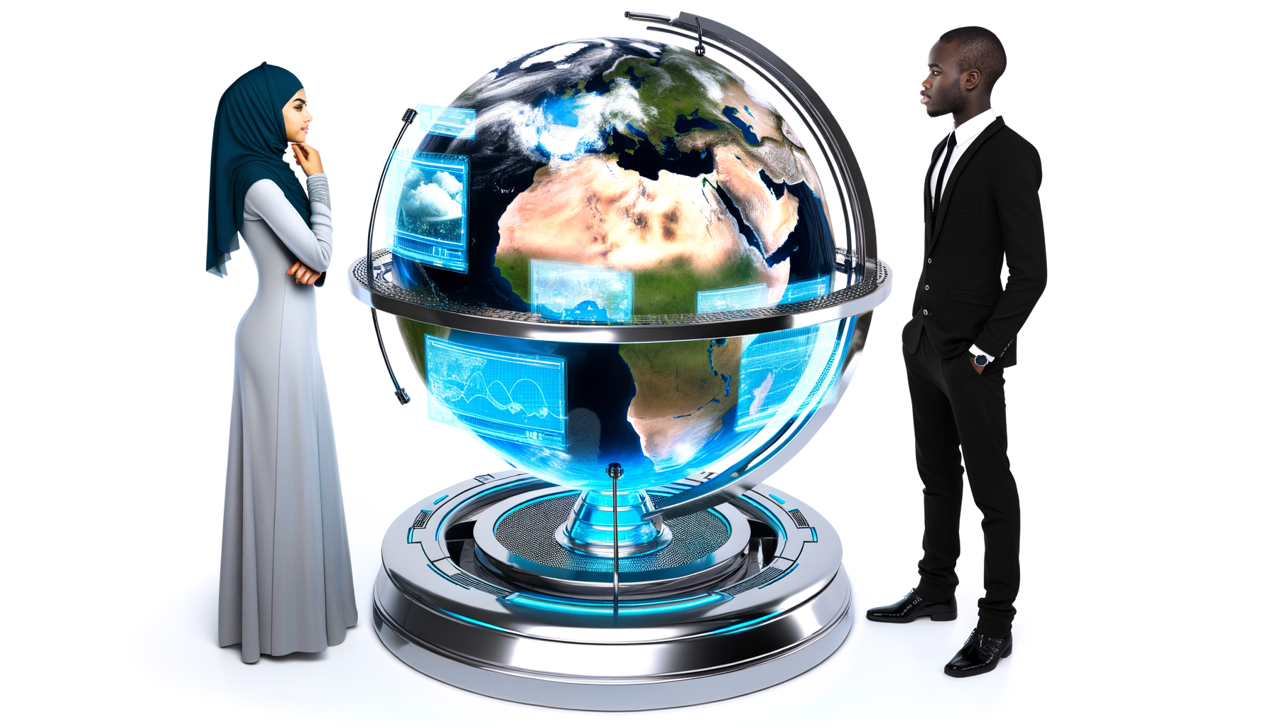
Dynamic Data Visualization and Connectivity
The true power of future globes lies in their ability to connect to and display dynamic, real-time data streams. Unlike a static printed surface, technologically advanced globes can become living maps, constantly updated with the latest information from various sources. This capability transforms the globe from a reference tool into an analytical and predictive one, reflecting the ever-changing nature of the Earth and human activity upon it.
Access to vast amounts of global data is now commonplace, thanks to satellites, ground sensors, internet connectivity, and computational power. The challenge and opportunity lie in effectively visualizing this data on a spherical surface in a way that is intuitive and informative. Future globes will serve as powerful interfaces for interacting with this data, allowing users to explore trends, understand complex systems, and see the interconnectedness of global phenomena.
Integrating Live Weather and Environmental Data
Imagine a globe that displays real-time cloud cover, tracks hurricanes as they develop, shows ocean currents, or visualizes the distribution of air pollution. Future globes can connect to meteorological satellites, weather stations, and environmental sensors to provide a live, constantly updating view of Earth's atmosphere and oceans. This capability is invaluable for education, demonstrating the dynamics of weather systems and climate in a way that static diagrams cannot.
Beyond weather, they can show deforestation rates, track wildlife migration patterns, display seismic activity, or visualize changes in polar ice caps over time using historical and current satellite imagery. This allows for a much deeper understanding of environmental science and the impact of human activity on the planet, turning the globe into a powerful tool for ecological awareness and research. Visualizing these complex, dynamic processes on a global scale becomes intuitive on a spherical interface.
Population Trends and Geopolitical Information
Social and political data can also be layered onto future globes. Visualize real-time population distributions, track disease outbreaks, monitor global migration flows, or display economic indicators across different regions. Geopolitical events, election results, or trade routes could be visualized dynamically, offering insights into human geography and global interconnectedness in ways previously only possible with complex statistical software or flat interactive maps.
The ability to toggle between different data layers allows for rich comparative analysis. A user could look at population density alongside resource availability, or overlay historical conflict zones with current political boundaries. This transforms the globe into a powerful tool for social studies, political science, economics, and humanitarian efforts, making abstract global data tangible and understandable within a geographical context.
Interactive Displays and Touch Technology
Moving beyond simple AR overlays on passive objects, technological advancements enable the creation of fully interactive, spherical displays. These might take the form of large, globe-shaped touchscreens or spheres onto which dynamic images are projected. Users can interact directly with the surface, touching locations to pull up information, zooming in with gestures, or swiping to change data layers.
Spherical projection mapping technology, for example, allows any sphere to become a display surface. High-resolution projectors can cast dynamic, seamless imagery onto a white ball, creating a stunning visual effect that appears just like a solid globe displaying moving maps, animations, or data visualizations. These can range in size from small desk models to massive installations in museums or public spaces.
Touch-sensitive surfaces applied to a physical globe or combined with projection mapping further enhance interactivity. This allows for direct manipulation and exploration, making the experience highly intuitive, similar to using a large tablet but on a spherical canvas. Such interactive displays are ideal for public exhibits, educational centers, and collaborative workspaces where multiple users might interact with the globe simultaneously.
Advanced Materials and Manufacturing
The physical construction of future globes is also benefiting from innovation. Advanced materials can provide durability and enhance display properties. Manufacturing techniques like 3D printing allow for the creation of complex, potentially textured or multi-layered spherical forms that might be difficult or expensive to produce using traditional methods. These can serve as the base for projection mapping or incorporate embedded sensors or components.
'Smart' materials could potentially change color or display limited information themselves, although full dynamic display typically requires projection or integrated screens. However, materials science can contribute to creating robust, visually appealing, and accurately formed spheres that serve as the foundation for technological overlays and interactions, ensuring the physical object itself remains a high-quality representation.
The Future of Globes: Applications and Experiences
The integration of these technologies isn't just about creating novelty; it's about unlocking powerful new ways to use globes in various contexts. The future of globes lies in their ability to serve as versatile platforms for learning, analysis, planning, and personal discovery, moving far beyond their historical role as static geographical references. Their spherical nature makes them uniquely suited for visualizing global phenomena, and technology enhances this inherent strength.
From enhancing educational outcomes to providing critical tools for professional fields, the potential applications are vast and transformative. The ability to interact with dynamic, layered geographical information on a global scale opens up possibilities that were previously confined to specialized software or complex digital platforms, bringing them into a more accessible and intuitive format.
Educational Tools for a New Generation
The classroom stands to benefit immensely from technologically advanced globes. AR-enhanced globes can make geography lessons come alive, allowing students to visualize concepts like plate tectonics, ocean currents, or climate zones in 3D directly on the globe's surface. Teachers can overlay historical maps to show how borders have changed or display data on global trade routes to illustrate economic interconnectedness.
VR globe experiences can take students on virtual field trips to explore different biomes, visit historical sites, or understand the scale of geographical features like the Grand Canyon or Mount Everest from a unique perspective. The interactive nature keeps students engaged, and the ability to access deep layers of information empowers them to explore topics at their own pace and level of curiosity, fostering a deeper understanding of the world. These tools cater to diverse learning styles, making geography more accessible and exciting.
Professional and Research Applications
Beyond education, dynamic, data-rich globes have significant potential in professional and research fields. Urban planners could visualize population growth, traffic flow, and infrastructure development on a global or regional sphere. Logisticians and supply chain managers could track shipments, optimize routes, and visualize global distribution networks in real-time. Resource managers could monitor deforestation, water usage, or mineral extraction sites.
Researchers across various disciplines – from environmental science and climatology to epidemiology and social sciences – could use interactive globes to visualize complex data sets, identify patterns, and communicate findings effectively. A climate scientist could display temperature anomalies or sea-level rise projections directly on a spherical model, making abstract data concrete and impactful. These platforms offer a powerful way to synthesize and present complex global information.
Art, Design, and Personal Exploration
The aesthetic appeal and interactive potential of futuristic globes also open doors for art, design, and personal use. Interactive globes can be stunning pieces of dynamic art in public spaces, displaying ever-changing patterns, visualizations of internet traffic, or global cultural data. Designers can use them as unique display surfaces for creative projects.
For personal use, AR or projection globes can become fascinating conversation pieces and tools for exploration. Users could display family travel history, visualize their online connections across the world, explore astronomical data displayed on a celestial sphere, or simply enjoy dynamic, high-resolution maps that update automatically. The personal connection to geography is enhanced by the ability to customize and interact with the display in meaningful ways.
Accessibility and Inclusivity
Technology can also make geographical information more accessible. While traditional globes are primarily visual and tactile, digital overlays can incorporate audio descriptions, text information, and customizable display options. VR experiences can be designed with accessibility in mind, and AR interfaces can provide information in multiple formats. This potential helps ensure that more people, regardless of learning style or disability, can engage with and understand global geography.
Challenges and Opportunities in the Evolution of Globes
While the potential of technology-enhanced globes is immense, realizing this future comes with its own set of challenges. These aren't insurmountable obstacles but rather areas that require focus, investment, and innovation to ensure that the transition from static models to dynamic platforms is successful and beneficial. Addressing these challenges also highlights significant opportunities for companies and researchers in this emerging field.
The development of robust hardware, seamless software integration, reliable data streams, and user-friendly interfaces are all critical components. Furthermore, considerations around cost, data accuracy, and market adoption need careful planning to bring these futuristic concepts into widespread use. The success of future globes will depend on overcoming technical hurdles and creating compelling, valuable user experiences.
Technical Hurdles and Development Costs
Developing high-resolution spherical displays or projection systems that are affordable for widespread use is technically challenging. Creating robust AR applications that accurately track and overlay data onto a physical globe in varying lighting conditions requires sophisticated software and hardware. VR development, while rapidly advancing, still requires specialized headsets that may not be universally accessible.
The integration of multiple data streams into a single, coherent, and smoothly updating visualization on a spherical surface is also complex. Ensuring low latency and high performance is crucial for a good user experience, especially with real-time data. These technical complexities often translate into high development and manufacturing costs, which can be a barrier to entry for both producers and consumers, particularly in educational settings with limited budgets.
Data Management and Accuracy
The value of a dynamic globe is directly tied to the quality and reliability of the data it displays. Sourcing, cleaning, integrating, and constantly updating diverse data sets – from weather and environmental data to population statistics and geopolitical information – is a massive data management task. Ensuring the accuracy, currency, and integrity of this data is paramount.
Furthermore, visualizing complex data accurately and without distortion on a spherical surface requires sophisticated mapping and rendering techniques. Misrepresenting data due to poor visualization or inaccurate sources could undermine the educational and analytical value of the globe. Establishing standards for data integration and visualization will be important for the credibility of these platforms.
Market Adoption and User Experience
Introducing fundamentally new ways of interacting with a classic object like the globe requires careful consideration of user experience. The interfaces need to be intuitive and easy to use for people of all ages and technical abilities. The perceived value must justify the cost and the potential learning curve associated with new technology.
Convincing educational institutions, businesses, and consumers to invest in these new technologies requires demonstrating their clear advantages over traditional globes and other digital mapping tools. Marketing and user education will play a significant role in driving adoption. Creating compelling content and applications that showcase the unique capabilities of spherical, dynamic visualization will be key to market success.
The Opportunity for Deeper Understanding
Despite the challenges, the opportunities presented by the future of globes are profound. By making global data accessible and interactive in an intuitive spherical format, these technologies have the potential to significantly deepen our understanding of the Earth and the complex systems that shape it. They can make abstract concepts tangible, connect local events to global trends, and foster a greater sense of global citizenship.
There is an opportunity to develop innovative educational content, create powerful analytical tools for professionals, and design engaging experiences for the public. Companies that can successfully integrate hardware, software, and data streams into user-friendly, compelling globe products stand to capture a significant market in education, research, and consumer technology. The potential for impact on how we learn about and interact with our planet is immense.
Conclusion: A World Transformed
The journey from static, paper-covered spheres to dynamic, interactive data portals represents a monumental leap in the evolution of the globe. While the traditional globe will always hold a place for its simple elegance and foundational utility, technology is undeniably shaping its future, transforming it into a powerful, multifaceted tool for the 21st century and beyond. This transformation is driven by the need to represent a world that is increasingly interconnected, complex, and constantly in motion.
Technologies such as augmented reality, virtual reality, dynamic data visualization, and interactive displays are not just augmenting the globe; they are reinventing the very concept of how we visualize and interact with global information. They promise educational experiences that are more immersive and engaging, professional tools that offer unprecedented analytical capabilities, and personal devices that foster curiosity and a deeper connection to our planet. The potential applications stretch across learning, business, science, and art.
While challenges remain in terms of technical development, data management, and market adoption, the opportunities for innovation and positive impact are significant. By overcoming these hurdles, developers and educators can unlock the full potential of the spherical format, turning the globe into a living atlas that reflects the dynamic reality of Earth. The future of globes is bright, promising a more informed, interactive, and ultimately, a more connected way for us to see and understand our place in the world.
As technology continues to advance, we can anticipate globes becoming even more sophisticated, capable of displaying richer data, offering more seamless interactions, and integrating with other smart devices and platforms. The vision of a dynamic, intelligent globe that serves as a hub for global understanding is rapidly moving from concept to reality, forever changing how we explore our incredible planet. The next generation of globes will not just show us the world; they will help us understand its pulse.