


Raised Relief Maps: Transforming Education and Therapy Through Touch
Maps have long been essential tools for understanding our world, helping us navigate distances, comprehend borders, and visualize geography. While flat maps provide vital information, they often fall short in conveying a crucial element of our planet's surface: topography. The subtle curves, dramatic peaks, and sweeping valleys that define landscapes are often represented abstractly through contour lines or shading.
However, a different kind of map offers a powerfully intuitive way to grasp these physical features – the raised relief map. These three-dimensional representations literally bring the world into your hands, allowing you to feel the elevation changes, trace the flow of rivers, and understand the scale of mountain ranges through touch. This tactile dimension unlocks profound benefits, particularly in educational settings for diverse learners and within therapeutic practices aimed at enhancing sensory integration, motor skills, and cognitive function.
In this authoritative guide, we will delve deep into the world of raised relief maps, exploring their unique characteristics and unveiling the compelling advantages they offer for both teaching and therapy. We will identify the main points relevant to educators, therapists, parents, and individuals seeking alternative learning or therapeutic tools, and demonstrate how these maps provide an effective, multi-sensory solution to enhance understanding, engagement, and developmental progress. Discover how touching the world can change how we learn and heal.
What Exactly Are Raised Relief Maps?
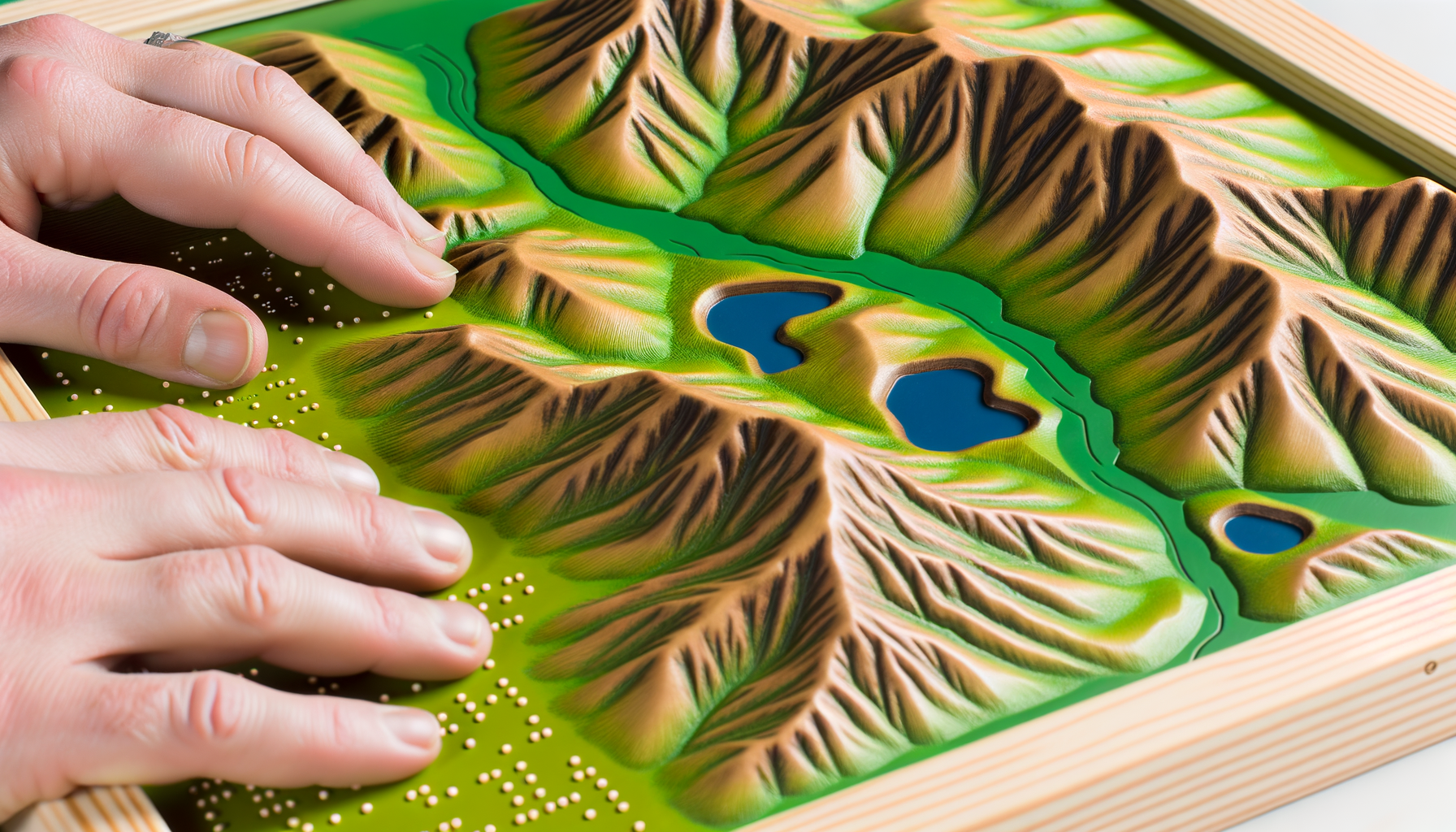
At its core, a raised relief map is a map where the elevation of the terrain is represented physically, causing features like mountains, hills, and valleys to project outwards from the surface. Unlike a standard flat map that uses visual cues like color gradients or contour lines to indicate elevation, a raised relief map provides a three-dimensional model of the landscape. You can literally run your fingers over the surface and feel the changes in altitude.
These maps are typically made by printing a standard map onto a plastic or vacuum-formed sheet, and then molding or sculpting the material to match the topographic data. The vertical scale is often exaggerated compared to the horizontal scale to make the terrain features more prominent and easily discernible to the touch. This exaggeration is key to their effectiveness, allowing users to easily perceive elevation changes that might be too subtle on a true-to-scale model.
They come in various sizes, from small handheld models of specific regions to large wall-mounted maps covering continents or the entire world. Their construction makes them durable and suitable for repeated physical interaction, which is essential for both their educational and therapeutic applications. Understanding what they are – maps you can feel – is the first step to appreciating their significant value.
The Unique Power of Tactile Learning
Human beings are multi-sensory creatures, and learning is most effective when multiple senses are engaged simultaneously. While traditional learning often relies heavily on visual and auditory input, the sense of touch, or tactile learning, plays a critical role in how we perceive and understand the world around us. Tactile learning involves processing information through physical contact and manipulation.
For many learners, particularly those who are kinesthetic learners or have visual impairments or learning differences like dyslexia or ADHD, tactile input can provide an essential pathway to understanding. Feeling an object or a surface allows the brain to create a concrete, physical representation of the concept being taught. This hands-on experience can solidify understanding in a way that abstract visual or auditory information cannot.
Raised relief maps tap directly into this powerful learning modality. By allowing users to feel the mountains, valleys, plains, and coastlines, these maps create a direct physical connection to geographical concepts. This tactile engagement helps bypass potential barriers presented by purely visual or abstract representations, making complex information more accessible and memorable. It transforms passive viewing into active exploration.
This multi-sensory approach doesn't just benefit specific learning styles; it enhances learning for *everyone*. Engaging multiple senses simultaneously leads to stronger neural connections and a deeper level of processing, resulting in improved retention and comprehension. The act of touching and exploring the map physically reinforces the visual information, creating a richer and more robust learning experience.
Educational Applications of Raised Relief Maps
Raised relief maps are invaluable tools in educational settings, offering unique advantages over traditional flat maps. They make geographical concepts tangible and significantly enhance the learning experience for students of all ages and abilities. Their three-dimensional nature allows for a deeper and more intuitive understanding of the Earth's surface.
H3 Teaching Core Geographical Concepts
One of the most direct educational uses of raised relief maps is in teaching fundamental geographical concepts related to topography. Students can easily visualize and feel the difference between a mountain range, a plateau, a valley, or a plain. Tracing the path of a river as it flows from higher elevations through lower terrain becomes a concrete exercise rather than an abstract concept.
Understanding watersheds, drainage basins, and the impact of elevation on climate and human settlement is significantly aided by being able to physically interact with the terrain. Feeling the slope helps students grasp concepts like erosion, altitude, and how landforms influence weather patterns and ecosystems. They provide a realistic model that simplifies complex ideas.
H3 Enhancing Spatial Reasoning and Awareness
Spatial reasoning – the ability to think about objects in three dimensions and to understand their relationships to each other – is a critical cognitive skill. Raised relief maps are excellent tools for developing and enhancing spatial awareness. By manipulating the map or exploring it with their hands, students improve their ability to mentally visualize spaces and understand scale and proportion.
Activities like identifying the highest point, locating a specific landform relative to another, or planning a route across varied terrain directly exercise spatial reasoning skills. This type of skill is not only vital for geography but transfers to many other subjects including mathematics, science, and engineering, as well as everyday problem-solving and navigation. The tactile feedback provides essential input for building these mental models.
H3 Supporting Diverse Learners
Raised relief maps are particularly beneficial for students with diverse learning needs.
H4 Visual Learners and Kinesthetic Learners
For visual learners, the 3D model provides a clearer picture of terrain than 2D representations. Kinesthetic learners, who learn best through movement and doing, thrive on the tactile interaction that these maps offer. They can physically explore the landscape, using their hands to understand the information presented, making learning an active rather than passive process. This direct engagement helps solidify understanding.
H4 Students with Visual Impairments
For students who are blind or have low vision, raised relief maps are indispensable. They provide the primary means to access topographic information and develop a mental map of geographical areas based on touch. Many maps are available with Braille labeling alongside or instead of standard print, ensuring full accessibility. This opens up the study of physical geography to students who would otherwise face significant barriers.
They can feel the shape of continents, the paths of mountain ranges, and the contours of coastlines, gaining an understanding of the Earth's surface that is otherwise impossible through traditional visual maps. This tactile access promotes independence and equal opportunity in learning geography. Feeling the rise and fall of the land is a powerful way to build a spatial model in the mind.
H4 Students with Learning Differences (Dyslexia, ADHD)
Students with dyslexia or ADHD can sometimes struggle with processing complex visual information or maintaining focus during traditional lessons. Raised relief maps offer a concrete, engaging alternative that can help circumvent these challenges. The tactile nature provides a different pathway for processing information, and the hands-on interaction can help maintain focus and engagement. Manipulating the map provides a sensory anchor.
The ability to touch and feel the geography can make abstract concepts more concrete and easier to grasp. This multi-sensory approach reduces reliance on potentially challenging visual or textual information alone. It offers an alternative entry point into the subject matter that can significantly improve comprehension and participation for these students.
H3 Making Learning Engaging and Interactive
Simply put, raised relief maps are fun and engaging. They invite exploration and interaction in a way that flat maps cannot. Students are naturally drawn to touch them, leading to increased curiosity and motivation to learn about the geography they are feeling. This increased engagement can transform a potentially dry subject into an exciting discovery.
Teachers can design numerous interactive activities using these maps, such as scavenger hunts for specific landforms, modeling water flow with string, or tracing historical migration routes over mountains and across plains. This active learning approach fosters deeper understanding and retention than passive lectures or textbook reading alone. It turns geography into a hands-on adventure.
H3 Cross-Curricular Connections
Raised relief maps are not limited to geography lessons. They can serve as powerful tools in history, science, and social studies.
In history, understanding the terrain is crucial for understanding military campaigns, settlement patterns, and trade routes. Feeling the Alps helps explain why Hannibal's journey was so challenging. In science, they can illustrate geological processes, weather patterns, and ecosystem distribution. In social studies, they provide context for understanding human populations, resource distribution, and political boundaries in relation to physical geography. They provide a foundational context for numerous subjects.
Therapeutic Applications of Raised Relief Maps
Beyond the classroom, raised relief maps hold significant value in various therapeutic settings. Their tactile nature, visual information, and potential for structured interaction make them useful tools for addressing a range of developmental and cognitive needs. Therapists can utilize them to work on specific skills and achieve therapeutic goals in engaging ways.
H3 Occupational Therapy
Occupational therapists focus on helping individuals develop or regain skills needed for daily living. Raised relief maps can be valuable tools in this process.
H4 Fine Motor Skills and Dexterity
Interacting with a raised relief map can help develop fine motor skills. Tracing contour lines, following river paths with a finger, placing small markers on specific locations, or manipulating the map itself requires precision and control. These activities can be incorporated into therapy sessions to improve hand-eye coordination, finger strength, and dexterity, which are essential for tasks like writing, dressing, and eating.
The varying textures and elevations provide different sensory input that can challenge and refine fine motor movements. For example, navigating a finger through a narrow valley requires different motor planning than exploring a broad, flat plain or tracing the jagged edge of a mountain peak.
H4 Sensory Integration
Sensory integration therapy helps individuals process and respond to sensory information more effectively. Raised relief maps offer rich tactile and visual sensory input. The varied textures of mountains, valleys, water bodies, and flat areas provide diverse tactile experiences. The visual information adds another layer of sensory processing.
Exploring the map can provide proprioceptive input (sense of body position and movement) as the individual moves their hands across the surface. This multi-sensory engagement can be calming for some individuals by providing organizing sensory input, or alerting for others, depending on their specific needs and the way the activity is structured. It offers a controlled and predictable environment for sensory exploration.
H4 Spatial Awareness and Planning
Similar to their educational uses, raised relief maps aid in developing spatial awareness, a key area addressed in occupational therapy. Understanding one's position in space and the relationship between objects is fundamental for tasks like navigating an environment, organizing a workspace, or even understanding personal space.
Using the map to plan a route, identify landmarks, or understand directions helps improve spatial reasoning and planning skills. This translates directly to real-world tasks, improving independence and safety. The tactile and visual input together create a strong foundation for spatial understanding.
H3 Physical Therapy
While perhaps less obvious than occupational therapy, raised relief maps can also be integrated into physical therapy.
H4 Balance and Coordination
Large format or floor-based raised relief maps can be used in activities that promote balance and coordination. Navigating around or stepping over different elevations on the map while maintaining balance can be a therapeutic exercise. This is particularly useful for working with individuals recovering from injuries or those with neurological conditions affecting gait and balance.
Pointing to locations or tracing routes while standing can also integrate upper and lower body coordination. The map provides a visually and tactilely interesting surface that can motivate engagement in physical exercises. It turns functional movement into a purposeful activity tied to exploring geography.
H4 Body Awareness and Motor Planning
Understanding one's body in space (body awareness) and planning movements (motor planning) are often targets in physical therapy. Interacting with a raised relief map can support these goals. Moving hands and fingers across the terrain provides feedback about body position and movement.
Planning a complex movement sequence to trace a challenging route on the map, or coordinating hand and arm movements to explore a large area, directly works on motor planning skills. The physical engagement with the map reinforces the connection between thought, plan, and action.
H3 Cognitive Therapy
Raised relief maps can be effective tools in cognitive therapy, which aims to improve cognitive skills such as memory, problem-solving, attention, and executive functions.
H4 Memory and Recall
Using the map to learn and recall geographical locations, features, or routes can be a memory exercise. The multi-sensory nature of the map aids memory encoding; the tactile input provides an additional cue for recall compared to a purely visual map. Therapists can use activities like locating specific places learned previously or recalling details about different types of terrain.
Building spatial memory by navigating the map mentally or physically helps reinforce geographical information and improves overall memory function. The act of physically interacting with the information strengthens the memory trace.
H4 Problem-Solving and Planning
Raised relief maps offer opportunities for problem-solving and planning tasks. Activities might include planning the most efficient route considering the terrain, identifying potential challenges like mountain ranges or rivers, or determining the best location for a settlement based on physical features. These tasks require analysis, strategic thinking, and decision-making.
Working through these geographical challenges on the map helps individuals practice and improve their problem-solving and executive function skills in a concrete and engaging context. The physical model makes the problem tangible and easier to manipulate mentally.
H4 Attention and Focus
For individuals who struggle with attention, the tactile and visually stimulating nature of raised relief maps can help maintain focus. The active engagement required to explore the map can be more attention-grabbing than passive observation. Therapists can design activities that require sustained attention to detail, such as tracing intricate coastlines or identifying subtle elevation changes.
The physical interaction provides a grounding element that can help individuals stay present and focused on the task at hand. It offers a tangible point of reference to return to if attention wanders.
H3 Sensory Integration Therapy
As touched upon in occupational therapy, raised relief maps are fundamentally sensory tools, making them ideal for dedicated sensory integration therapy. They provide a rich and varied sensory experience, primarily tactile and visual, but also potentially auditory if combined with verbal descriptions or sounds associated with different environments.
Individuals can explore different textures and shapes across the map's surface, providing valuable tactile input. This can be used to help individuals who are hypo- (under-responsive) or hyper- (over-responsive) sensitive to touch become better regulated. Controlled exploration of the map in a therapeutic setting allows for processing tactile input in a safe and guided manner.
The structured interaction with the map can be grounding and organizing, particularly for individuals who benefit from predictable sensory input. It offers a defined activity with clear physical boundaries and opportunities for directed sensory exploration, contributing to a sense of calm and focus.
H3 Emotional Regulation
For some individuals, particularly children, engaging with a raised relief map can be a calming and regulating activity. The focused, tactile exploration can provide a sense of grounding and control. Running hands over the familiar contours can be repetitive and soothing.
Using the map in a therapy session or at home can provide a safe and engaging activity during moments of dysregulation or anxiety. It offers a positive distraction and a physical outlet for sensory needs, helping individuals to become more present and regulated. The act of touching and feeling can be inherently calming.
Specific Applications and Examples
Raised relief maps are versatile and can be used in numerous settings and with various populations to achieve educational and therapeutic outcomes. Their adaptability makes them valuable resources in many different contexts.
H3 In Classroom Settings
From elementary school to university, raised relief maps can enhance learning. In younger grades, they help introduce basic concepts of landforms and bodies of water through play and exploration. In higher grades, they can be used for complex studies of geology, environmental science, or historical geography, providing a tangible model for analysis. A classroom globe with raised relief is a common example, but large wall maps offer even more detail.
H3 In Therapy Clinics
Occupational therapists might have a raised relief map on the floor or a table for clients to crawl over, walk around, or explore while seated, incorporating gross or fine motor goals. A sensory integration room might use a map as one of several tactile stations. Cognitive therapists can use maps for tasks involving spatial memory or route planning exercises. Physical therapists might incorporate balance activities around a large map.
H3 In Homes
Parents can use raised relief maps to supplement their child's education, making homework more engaging or exploring family vacation destinations in a hands-on way. For children with sensory needs, a map can be a calming sensory tool for quiet exploration. It provides an opportunity for interactive learning outside of formal settings.
H3 In Museums and Libraries
Public spaces like museums and libraries often feature raised relief maps as interactive exhibits. They allow visitors of all ages and abilities, including those with visual impairments, to physically engage with geography, making the information more accessible and memorable. They serve as educational displays that encourage hands-on learning.
H3 Working with Specific Populations
Raised relief maps are particularly impactful when working with specific groups.
H4 Children
Children are naturally drawn to tactile exploration. Raised relief maps cater to this innate curiosity, making learning fun and accessible for very young learners as well as older students. They are excellent for developing early spatial concepts.
H4 Adults with Disabilities
For adults with cognitive or physical disabilities, raised relief maps can be used in therapy to maintain or improve skills related to spatial awareness, fine motor control, memory, or sensory processing. They provide a structured and engaging activity that can be adapted to various ability levels.
H4 Seniors
In geriatric therapy or activities, raised relief maps can be used for cognitive stimulation, memory recall (e.g., remembering places visited), and fine motor exercises. Exploring a familiar place on a tactile map can also be a comforting and grounding activity.
Choosing the Right Raised Relief Map
Selecting the appropriate raised relief map depends on its intended use, the age and abilities of the users, and the specific geographical area of interest.
Consider the size and scale: A large wall map is great for group learning or therapy sessions focusing on gross motor movement or spatial awareness of a large area. Smaller, handheld maps are better for individual tactile exploration, fine motor work, or studying specific regions in detail.
Look at the level of detail and exaggeration: Some maps have subtle relief, while others have highly exaggerated vertical scales to emphasize terrain for tactile exploration. The level of detail in labeling and topography should match the users' needs. For users with visual impairments, ensure Braille labeling is included if needed.
Consider the material and durability: Most are made from durable plastic, but quality varies. For frequent handling in classrooms or therapy settings, choose a robust map that can withstand repeated physical interaction. Ensure the material is safe and non-toxic, especially if used by young children.
Integrating Raised Relief Maps Effectively
Simply having a raised relief map is not enough; maximizing its benefits requires thoughtful integration into educational or therapeutic plans.
For educators, encourage students to use the map actively. Ask them to trace routes, identify landforms by touch before sight, or use the map to visualize the setting of a historical event. Combine tactile exploration with discussions and other visual aids for a truly multi-sensory lesson. Design specific activities that require interaction with the 3D surface.
For therapists, identify specific therapeutic goals that can be addressed using the map (e.g., improving pincer grasp by placing small objects on mountain peaks, enhancing sequencing by planning a multi-step route, or providing calming deep pressure input by running hands firmly over the surface). Incorporate map activities into treatment plans as a regular modality. Use the map as a prop for imaginative play in pediatric therapy.
For parents, use the map during reading time to locate story settings, plan imaginary trips, or help with geography homework in a fun, hands-on way. Leave the map accessible for spontaneous exploration. Ask open-ended questions about what they feel and see on the map.
Conclusion
In an increasingly digital world, the value of tangible, multi-sensory learning tools remains profound. Raised relief maps offer a unique bridge between abstract geographical information and concrete physical experience. They provide a powerful way to understand the Earth's surface that simply cannot be replicated by flat maps alone.
Whether used in a classroom to bring geography to life for diverse learners, in a therapy session to enhance motor skills, sensory processing, or cognitive function, or at home for engaging family learning, raised relief maps are much more than just educational aids – they are therapeutic tools. They open up avenues for understanding and interaction that cater to different learning styles and abilities, fostering deeper comprehension and greater engagement.
By incorporating raised relief maps into educational environments and therapeutic practices, educators and therapists can provide richer, more accessible, and more effective experiences. They empower individuals to literally touch the world and, in doing so, gain a more complete and meaningful understanding of its physical geography and their place within it. Explore the possibilities and bring the third dimension into your learning and therapeutic journey today.