


Beyond Flat Maps: Using Raised Relief Maps to Deeply Understand Population Density
Introduction: Connecting People, Places, and the Land's Shape
Understanding why people live where they do is a fundamental question in geography and human studies. It involves looking beyond mere numbers to grasp the intricate factors that influence settlement patterns. Population density, a measure of how many people inhabit a given area, tells us *what* the pattern is, but often leaves us wondering *why*.Traditional flat maps provide the statistical data for density, typically using colors or dots to show concentrations of people. While essential, these maps lack a crucial dimension: the physical shape of the land itself, the topography, which has historically and continues to profoundly impact where communities flourish and where they remain sparse.
This is where raised relief maps come into play, offering a unique and powerful solution. These three-dimensional representations of the Earth's surface provide a tangible, intuitive understanding of the landscape, revealing mountains, valleys, plains, and plateaus in their true physical form. By combining population density data with the visual and tactile information from a raised relief map, we unlock deeper insights into the forces that shape human distribution, offering a perspective that flat maps simply cannot match. This blog post will delve into how raised relief maps serve as invaluable tools for understanding the complex relationship between the physical environment and population density.
Defining the Core Concepts
Before we explore the powerful combination of raised relief maps and population density, it is essential to clearly define these two core concepts. A solid understanding of each element is necessary to appreciate the insights gained from using them together. Let's break down what population density means and what makes raised relief maps so unique and informative.What is Population Density?
Population density is a measurement used in demographics to express how crowded or dispersed a population is within a specific geographical region. It is typically calculated by dividing the total population of an area by the land area it occupies. The result is usually expressed as the number of people per square mile or per square kilometer.High population density indicates that many people live closely together in a limited space, often found in urban centers or fertile agricultural areas. Low population density, conversely, suggests that few people inhabit a large land area, characteristic of rural regions, deserts, or mountainous terrain. Analyzing population density is crucial for understanding the demands placed on resources, infrastructure, and services within a region, and it helps in planning for future growth and development.
On conventional maps, population density is commonly represented using choropleth maps, where areas are shaded based on their density value, or dot density maps, where each dot represents a fixed number of people. These methods are effective for showing the *distribution* of density, highlighting areas of high and low concentration. However, they often present this information in isolation from the underlying physical geography that frequently dictates these patterns.
Unpacking Raised Relief Maps
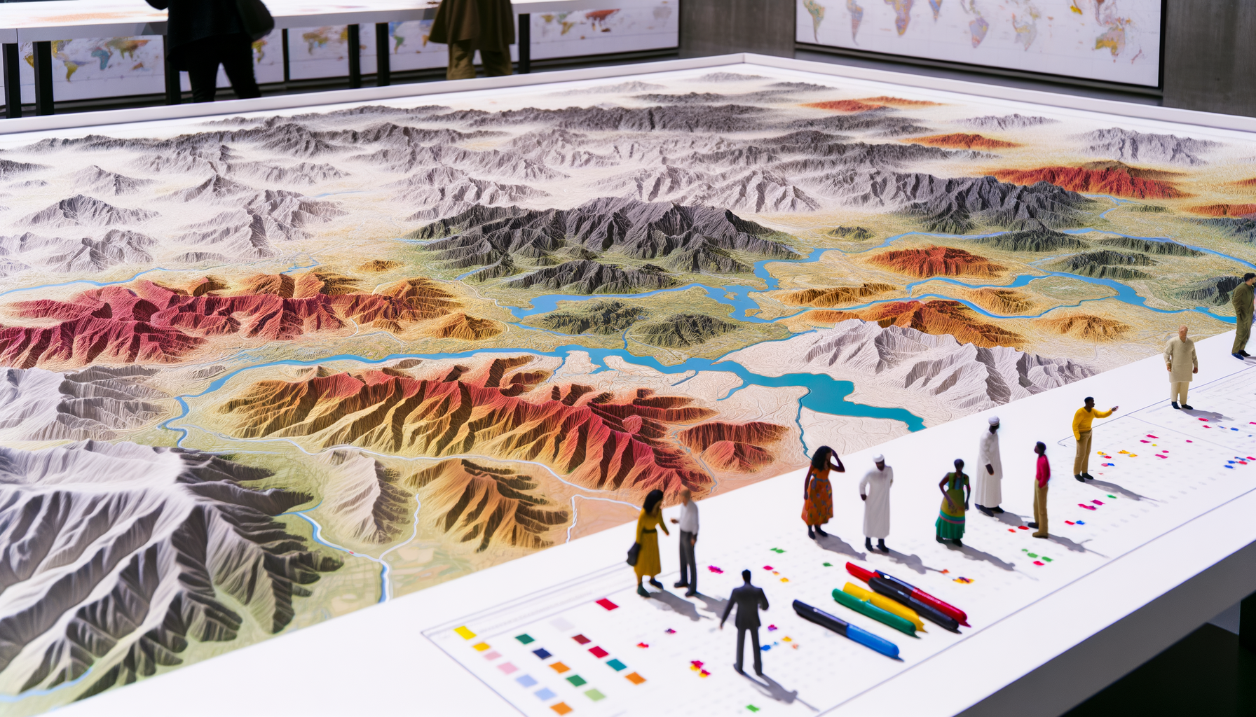
Raised relief maps are a special type of topographic map that use physical molding or digital elevation data to show the variations in the elevation of the Earth's surface in three dimensions. Unlike standard flat maps that use contour lines or shading to represent elevation, raised relief maps literally lift the landscape off the page. This physical or digitally rendered height provides a tangible sense of the topography, allowing users to see and even feel the slopes, peaks, and valleys.Historically, raised relief maps were crafted by hand, sculpting the terrain based on topographic data and then casting or molding it. Modern techniques often utilize digital elevation models (DEMs) and 3D printing or CNC routing to create highly accurate physical models, or sophisticated computer graphics to render interactive digital 3D landscapes. The key feature is that the vertical dimension is exaggerated relative to the horizontal dimension, which makes the terrain features more visually prominent and easier to interpret.
Raised relief maps are powerful tools because they provide an intuitive understanding of the landscape that is difficult to gain from flat representations alone. They immediately show steep slopes, flat plains, deep valleys, and high mountain ranges in a way that resonates with our natural perception of the physical world. This tangible representation is particularly valuable when trying to understand how the environment influences human activities, including where and how densely populations settle.
The Crucial Link: Topography and Human Settlement
The shape of the land, or topography, has been a primary determinant of human settlement patterns throughout history. Humans are not randomly distributed across the globe; their presence is heavily influenced by the opportunities and challenges presented by the physical landscape. Understanding this fundamental connection is key to appreciating the value of raised relief maps in the context of population density.Certain landforms are inherently more favorable for human habitation and development than others. Flat or gently rolling plains, for instance, offer fertile land for agriculture, ease of transportation, and relatively simple conditions for building infrastructure like roads, railways, and cities. These areas often support high population densities.
Conversely, rugged mountainous regions present significant challenges. Steep slopes make agriculture difficult and limit the availability of arable land. Building infrastructure is costly and complex, and transportation is often restricted to narrow winding routes. Extreme weather conditions and limited resources can also deter large settlements, resulting in low population densities.
Valleys, especially river valleys, often combine elements favorable to settlement: flat land along the riverbanks, access to water for drinking and irrigation, and sometimes fertile alluvial soils. Historically, many major civilizations and dense populations have clustered along prominent river systems like the Nile, the Indus, the Yangtze, and the Mississippi, nestled within valleys surrounded by more challenging terrain. Coastal areas with flat land and natural harbors also historically attract dense populations due to opportunities for trade, fishing, and transportation. The proximity to the ocean provides resources and facilitates connectivity with other regions, leading to major port cities and coastal population centers. The distribution of people is therefore deeply interwoven with the contours of the land.
Visualizing Density Through Relief: A Powerful Combination
While flat maps can show population density statistics, they often fail to visually communicate the *reasons* behind the patterns. A choropleth map might show a large, sparsely populated area next to a small, densely populated one, but without the context of the terrain, the contrast might seem arbitrary. This is where the integration of population data with raised relief maps provides transformative insight.Imagine looking at a standard map showing high population density along a coastal strip and low density inland. Now, visualize this same density data overlaid onto or viewed alongside a raised relief map of the same region. The relief map would immediately reveal a towering mountain range running parallel to the coast just a short distance inland. This visual juxtaposition makes the population pattern instantly understandable: people are concentrated on the flat, accessible coastal plain because the rugged, mountainous terrain inland is much less hospitable.
Raised relief maps allow us to perform a visual form of spatial analysis, correlating human settlement patterns with physical landscape features. We can see cities nestled in broad river valleys, dense populations clinging to narrow coastal lowlands, or vast empty spaces corresponding to formidable mountain ranges or arid plateaus. This intuitive understanding goes beyond memorizing facts; it fosters a genuine geographic intuition about the interplay between humans and their environment. The three-dimensional representation provides the essential geographic context that explains *why* the density map looks the way it does.
Practical Insights and Applications
The enhanced understanding provided by combining population density analysis with raised relief maps has significant practical applications across various fields. From the classroom to policy-making, these tools offer valuable perspectives.Enhanced Educational Understanding
For students learning geography, raised relief maps are invaluable teaching aids. They make abstract concepts like elevation, slope, and landforms tangible and relatable. Instead of just seeing contour lines on a page, students can touch and feel the mountain range, gaining a concrete understanding of the terrain's scale and complexity.When population density maps are used in conjunction with these relief models, students can physically see how population centers are located in valleys or plains and how sparser populations correspond to mountainous or rugged areas. This visual and tactile connection reinforces the fundamental principles of human geography and makes the relationship between physical environment and human settlement intuitively clear. It fosters a deeper and more memorable learning experience compared to studying flat maps alone.
Informing Urban Planning and Development
Urban planners and developers need a detailed understanding of both where people are currently located and the physical characteristics of the land. Raised relief maps or their digital equivalents, detailed topographic models, are essential tools in this process. They help planners identify areas suitable for development, considering factors like slope (affecting building costs and feasibility), drainage patterns (risk of flooding), and accessibility.By overlaying population density data onto detailed relief models, planners can analyze existing development in the context of the terrain and predict where future growth is likely or feasible. This helps in planning infrastructure, zoning land use, and mitigating potential risks associated with building on challenging terrain. Understanding density in relation to relief is crucial for sustainable urban expansion and resource management.
Resource Management and Environmental Analysis
The distribution of natural resources like water, fertile soil, and minerals is often tied to topography. Raised relief maps help visualize these connections. For instance, they clearly show drainage basins and the paths of rivers flowing through valleys, where access to water has historically attracted settlements. Understanding population density in relation to these topographic features is vital for managing water resources, planning agricultural land use, and assessing environmental impacts.Analyzing where people live relative to sensitive environmental areas, such as steep slopes prone to erosion or low-lying areas near floodplains, is critical for environmental protection and conservation efforts. Relief maps provide the essential spatial context to understand these vulnerabilities and plan accordingly. Resource managers use this integrated perspective to make informed decisions about land use and conservation strategies.
Emergency Services and Disaster Preparedness
In planning for and responding to natural disasters, understanding both population distribution and the terrain is paramount. Raised relief maps provide emergency services with a clear picture of the landscape, which is crucial for planning evacuation routes, identifying safe zones, and predicting the potential impact of events like floods, landslides, or wildfires.Knowing the density of populations in relation to vulnerable topographic features allows emergency planners to prioritize areas for monitoring and response. For example, identifying dense settlements located in floodplains (clearly visible on a relief map) allows for targeted early warning systems and evacuation plans. This spatial understanding saves lives and improves the efficiency of disaster response efforts. The combination of density data and terrain information is a powerful aid in ensuring public safety during crises.
Case Studies: Relief Shaping Density
Looking at specific geographic examples vividly illustrates how topography directly influences population density. The patterns we observe globally and regionally are not random; they are often a direct consequence of the opportunities and limitations imposed by the landforms. These case studies demonstrate the powerful insights gained when we consider population alongside relief.The Himalayas vs. The Ganges Plain
Contrast the towering peaks and deep valleys of the Himalayan mountain range with the vast, flat, and fertile Indo-Gangetic Plain stretching across northern India and Bangladesh. The Himalayas are one of the most sparsely populated regions on Earth, characterized by extremely low population density. The rugged terrain makes agriculture difficult, limits building sites, and restricts transportation, supporting only small, scattered communities often reliant on specialized livelihoods.Immediately to the south, the Ganges Plain is one of the most densely populated areas in the world. This region is characterized by exceptionally flat terrain, abundant water resources from the Himalayan rivers, and deep, fertile alluvial soils deposited over millennia. These conditions are ideal for intensive agriculture, supporting massive rural populations and fostering the growth of numerous large cities. A raised relief map showing the dramatic elevation change between the Himalayas and the plain makes this stark contrast in population density intuitively understandable; the land's shape directly dictates its capacity to support human life.
Coastal California vs. The Sierra Nevada
Along the coast of California, particularly in areas like the Los Angeles Basin and the San Francisco Bay Area, population densities are exceptionally high. This is despite challenges like seismic activity, as these areas offer relatively flat land near a major ocean for trade, and historically provided access to resources and transportation routes. The coastline and adjacent lowlands are magnets for human activity, leading to sprawling urban centers.Just a short distance inland lies the formidable Sierra Nevada mountain range, clearly depicted on a raised relief map by its significant height and ruggedness. This region has dramatically lower population densities. The steep slopes, high elevations, heavy snowfall, and limited flat land restrict settlement primarily to scattered towns in valleys or foothills. The physical barrier presented by the Sierra Nevada profoundly influences where California's vast population is concentrated, corralling much of it into the coastal strip and central valleys. The raised relief map provides the visual explanation for this pattern.
The Nile Valley in Egypt
Egypt's population distribution offers another compelling example of topography's influence, albeit in a different environmental context. Over 95% of Egypt's population lives in the narrow strip of fertile land along the Nile River and in its delta. This area is characterized by flat, irrigable land made productive by the river's waters and historical floods.Beyond this narrow green band, the vast majority of Egypt is arid desert, a flat or slightly undulating landscape but devoid of the water necessary for large-scale settlement. A raised relief map, while showing the flatness of the desert, also highlights the channel of the Nile, making it visually clear how this single topographic feature – a river carving a valley through the desert – is the lifeline supporting almost the entirety of the nation's dense population. The contrast between the densely populated, river-dependent valley and the sparsely populated, water-scarce surrounding desert is a powerful illustration of environmental control over human distribution.
Limitations and Considerations
While raised relief maps offer invaluable insights into the relationship between topography and population density, it is important to acknowledge their limitations. They are powerful tools, but they do not tell the entire story on their own. Understanding these considerations ensures a more complete and nuanced interpretation of the data.Topography as One Factor Among Many
Topography is a major influence on population density, but it is not the only one. Historical events, economic opportunities, political stability, cultural factors, and technological advancements also play significant roles in shaping where people live. For example, resource discoveries (like mining towns), political decisions (like capital city locations), or technological innovations (like large-scale irrigation projects) can lead to population concentrations in areas that might otherwise be considered less favorable based purely on relief. A raised relief map shows the physical potential and limitations, but other layers of information are needed for a complete picture.Data Resolution and Scale
The level of detail on a raised relief map or the resolution of the digital elevation model used is crucial. A small-scale map showing a large region might smooth over local topographic variations that significantly impact settlement patterns within smaller areas, such as small hills or stream valleys. Similarly, population data must be available at a compatible resolution; highly generalized population data layered onto a detailed relief model might obscure localized correlations. It is important to ensure that the map scale and data resolution are appropriate for the specific analysis being conducted.Currency of Population Data
How to Access and Utilize Raised Relief Maps
Accessing and using raised relief maps has become easier with advancements in technology, although traditional physical models still hold significant value, especially in educational settings. The method of access often depends on the intended use and desired level of detail.
Physical Raised Relief Models
Traditional physical raised relief maps are excellent teaching tools due to their tactile nature. They offer a direct, intuitive experience of the landscape's three-dimensionality. These models are often found in geography classrooms, museums, and visitor centers. They can be purchased from specialized educational and geographical supply companies. While they offer a compelling visual and tactile experience, they are static and typically cover specific, pre-defined regions. They are best for illustrating the general principle of how terrain influences large-scale patterns, providing a foundational understanding.
Digital Elevation Models (DEMs) and GIS Software
For detailed analysis and the ability to integrate various datasets, digital elevation models (DEMs) are the standard. These are raster datasets where each pixel's value represents the elevation at that location. DEMs can be processed using Geographic Information System (GIS) software (like ArcGIS, QGIS, or Google Earth Engine) to create interactive 3D visualizations of the terrain. Population density data, often available in compatible spatial formats, can be layered directly onto these digital relief models. This allows for sophisticated spatial analysis, such as identifying all areas with a certain population density within a specific elevation range or calculating the average slope in densely populated areas.
Online Tools and Interactive Maps
Many online mapping platforms and geographical data portals now offer terrain views derived from DEMs. While perhaps not as detailed or manipulable as dedicated GIS software, these platforms often allow users to toggle between flat map views and 3D terrain views. Some even allow for layering basic demographic data. Google Earth is a prominent example, allowing users to visualize population data (sometimes available through third-party layers) on its detailed 3D terrain model. These tools make the insights provided by relief maps accessible to a wider audience for casual exploration and basic analysis.
Conclusion: Seeing the World in 3D
Understanding population density is crucial for countless applications, from resource management and infrastructure planning to educational instruction and disaster preparedness. While flat maps provide essential statistical data on where people live, they often fall short in explaining *why* populations are distributed in specific patterns across the landscape. This is where the unique perspective offered by raised relief maps becomes indispensable.
By providing a tangible, three-dimensional representation of the Earth's topography, raised relief maps visually unlock the profound influence of landforms on human settlement. They allow us to intuitively connect areas of high population density with favorable terrain like fertile plains and accessible valleys, and areas of low density with challenging landscapes such as steep mountains and rugged plateaus. This connection between the physical world and human distribution is fundamental to geographic understanding.
Whether through physical models in a classroom or sophisticated digital visualizations in a planning office, raised relief maps provide a powerful and intuitive way to see the world. They transform abstract data into understandable patterns by providing the crucial geographic context of the land's shape. Embracing the use of raised relief maps enhances our ability to analyze, understand, and make informed decisions about population distribution and its intricate relationship with the diverse and dynamic surface of our planet. Seeing the world in 3D truly changes how we understand where and why we live.
How to Access and Utilize Raised Relief Maps
Accessing and using raised relief maps has become easier with advancements in technology, although traditional physical models still hold significant value, especially in educational settings. The method of access often depends on the intended use and desired level of detail.Physical Raised Relief Models
Traditional physical raised relief maps are excellent teaching tools due to their tactile nature. They offer a direct, intuitive experience of the landscape's three-dimensionality. These models are often found in geography classrooms, museums, and visitor centers. They can be purchased from specialized educational and geographical supply companies. While they offer a compelling visual and tactile experience, they are static and typically cover specific, pre-defined regions. They are best for illustrating the general principle of how terrain influences large-scale patterns, providing a foundational understanding.Digital Elevation Models (DEMs) and GIS Software
For detailed analysis and the ability to integrate various datasets, digital elevation models (DEMs) are the standard. These are raster datasets where each pixel's value represents the elevation at that location. DEMs can be processed using Geographic Information System (GIS) software (like ArcGIS, QGIS, or Google Earth Engine) to create interactive 3D visualizations of the terrain. Population density data, often available in compatible spatial formats, can be layered directly onto these digital relief models. This allows for sophisticated spatial analysis, such as identifying all areas with a certain population density within a specific elevation range or calculating the average slope in densely populated areas.Online Tools and Interactive Maps
Many online mapping platforms and geographical data portals now offer terrain views derived from DEMs. While perhaps not as detailed or manipulable as dedicated GIS software, these platforms often allow users to toggle between flat map views and 3D terrain views. Some even allow for layering basic demographic data. Google Earth is a prominent example, allowing users to visualize population data (sometimes available through third-party layers) on its detailed 3D terrain model. These tools make the insights provided by relief maps accessible to a wider audience for casual exploration and basic analysis.Conclusion: Seeing the World in 3D
Understanding population density is crucial for countless applications, from resource management and infrastructure planning to educational instruction and disaster preparedness. While flat maps provide essential statistical data on where people live, they often fall short in explaining *why* populations are distributed in specific patterns across the landscape. This is where the unique perspective offered by raised relief maps becomes indispensable.By providing a tangible, three-dimensional representation of the Earth's topography, raised relief maps visually unlock the profound influence of landforms on human settlement. They allow us to intuitively connect areas of high population density with favorable terrain like fertile plains and accessible valleys, and areas of low density with challenging landscapes such as steep mountains and rugged plateaus. This connection between the physical world and human distribution is fundamental to geographic understanding.
Whether through physical models in a classroom or sophisticated digital visualizations in a planning office, raised relief maps provide a powerful and intuitive way to see the world. They transform abstract data into understandable patterns by providing the crucial geographic context of the land's shape. Embracing the use of raised relief maps enhances our ability to analyze, understand, and make informed decisions about population distribution and its intricate relationship with the diverse and dynamic surface of our planet. Seeing the world in 3D truly changes how we understand where and why we live.