


Mastering Digital Map Tools for Seamless Travel Planning: Your Ultimate Guide
From Folded Paper to Dynamic Screens: The Evolution of Travel Planning
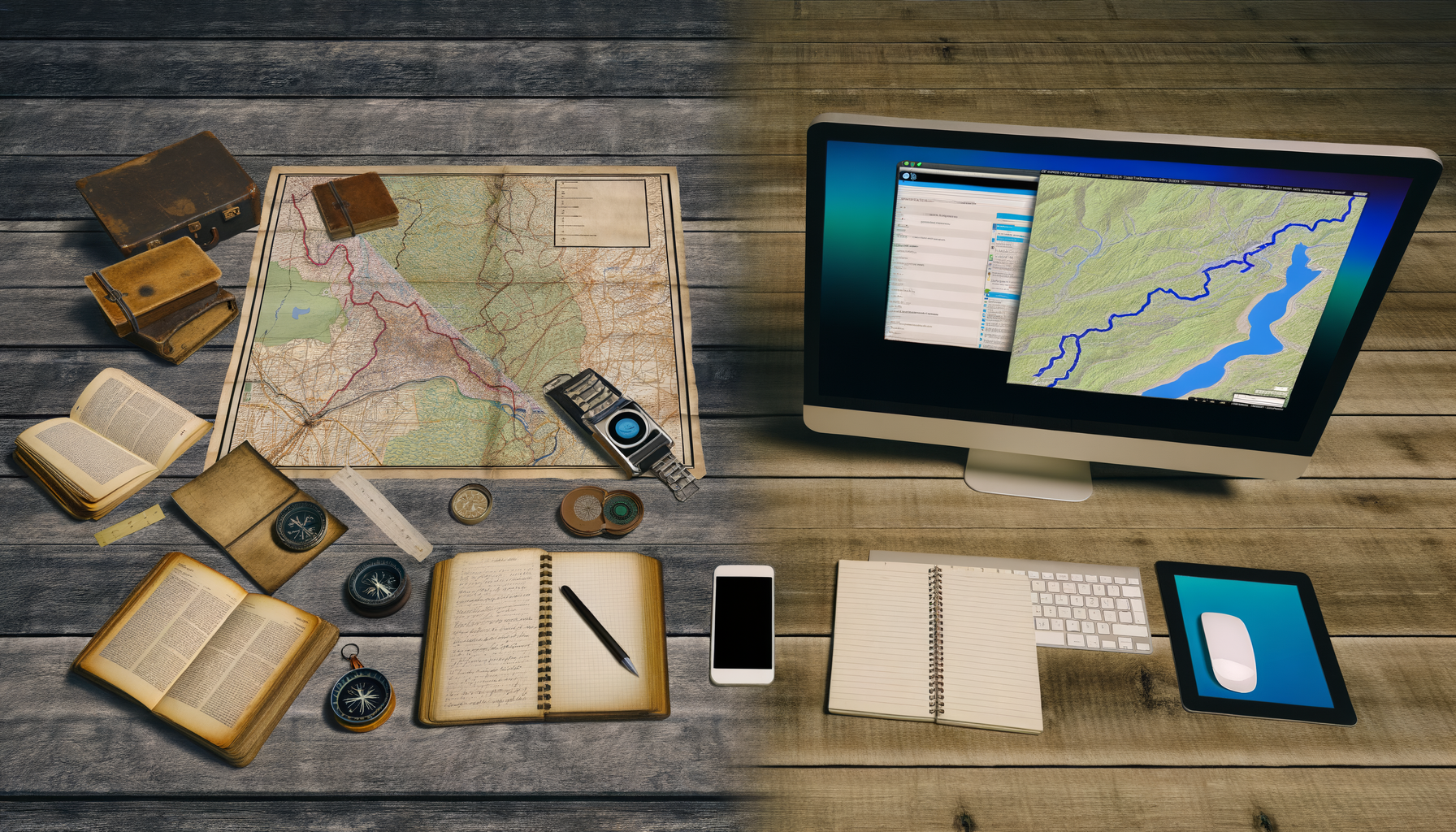
For generations, the trusty paper map was the cornerstone of travel planning and navigation. Spread across a table, marked with highlighters and handwritten notes, it offered a tangible view of the journey ahead. It required careful folding, understanding legends, and often a co-pilot to decipher directions on the road.
While nostalgic, the static nature of paper presented limitations in a rapidly changing world. Real-time information, dynamic route adjustments, and the ability to easily discover hidden gems were simply beyond its capabilities. The digital age ushered in a revolutionary shift, transforming how we visualize, plan, and execute our travels, placing incredible power in the palm of our hands.
Travel planning in the 21st century is fundamentally different, thanks to the proliferation of sophisticated digital map tools. These aren't merely digital versions of old maps; they are dynamic, interactive platforms packed with features designed to make every stage of your trip, from initial inspiration to on-the-ground navigation, smoother and more informed. They address the complexities of modern travel by providing instant access to vast amounts of data and powerful planning functionalities.
This guide dives deep into the world of digital map tools, specifically focusing on how you can leverage their full potential for comprehensive travel planning. We will explore the different types of tools available, unpack their essential features, detail the immense benefits they offer over traditional methods, and provide a step-by-step approach to using them effectively to build your perfect itinerary. Whether you are planning a weekend getaway or a multi-month adventure, mastering these digital resources is key to a successful and stress-free trip.
What Exactly Are Digital Map Tools for Travel Planning?
At their core, digital map tools for travel planning are software applications or web-based platforms that utilize geographical data to help users visualize, organize, and navigate trips. Unlike simple digital navigation apps, those geared towards planning often include features beyond just getting from point A to point B. They are integrated ecosystems designed to support the entire travel lifecycle.
These tools go far beyond showing roads and landmarks. They layer rich contextual information onto the map, including points of interest, photos, reviews, operating hours, transportation options, traffic conditions, and even collaborative features. This wealth of data turns a simple map into a dynamic planning canvas, allowing travelers to research, save locations, build itineraries, and prepare for their journey in unprecedented ways.
Essential Types of Digital Map Tools for Travelers
The digital mapping landscape for travelers is diverse, offering a range of tools from ubiquitous general-purpose platforms to highly specialized applications. Understanding the different types can help you choose the best fit for your specific planning needs and travel style. Most travelers end up using a combination of these tools for different aspects of their trip.
General-Purpose Mapping Platforms
These are the giants of the digital mapping world, widely used for daily navigation but also packed with powerful features for travel planning. They offer comprehensive global coverage and are constantly updated, making them indispensable for most trips. Their strength lies in their breadth of data and widespread familiarity.
Google Maps
Arguably the most popular digital map tool globally, Google Maps is a powerhouse for travel planning. Its extensive database of businesses, landmarks, and points of interest is incredibly detailed, often including photos, reviews, contact information, and operating hours. You can easily search for virtually anything along your potential route or at your destination.
Key planning features include the ability to save locations into custom lists, which can be organized by trip or interest. Users can also plan multi-stop routes, check transit schedules, view traffic predictions, utilize Street View for virtual exploration, and download offline maps for areas with limited connectivity. Its integration with other Google services, like Google Search and reviews, further enhances its utility as a planning tool.
Apple Maps
The default mapping application for Apple devices, Apple Maps has significantly improved over the years to become a strong contender in the travel planning space. It offers detailed maps, turn-by-turn navigation, transit information, and features like "Look Around" (a street-level view similar to Street View) in many major cities.
For planning, Apple Maps allows users to save favorite locations and create "Guides" – curated lists of places for a specific trip or theme. These Guides can be shared with others, making collaboration easier. While its POI database might not always be as comprehensive as Google Maps in every corner of the world, it is robust for popular destinations and offers a clean, user-friendly interface particularly appealing to iOS users.
Specialized Travel Planning Platforms and Apps
Beyond the general giants, numerous apps and websites are specifically designed with travel planning in mind. These often offer unique features tailored to specific types of trips, collaborative planning, or integrating maps with other itinerary details like bookings and reservations. They often provide a more structured approach to building a trip itinerary on a map base.
Examples include apps like Maps.me, which excels in offline map capabilities using OpenStreetMap data; Komoot, popular among hikers and cyclists for detailed trail maps and route planning; and dedicated travel itinerary apps like TripIt or Wanderlog, which integrate booking confirmations with map visualizations of your planned locations. These specialized tools can add layers of functionality not found in general mapping apps, catering to niche interests or complex planning needs.
Unpacking the Power: Key Features of Digital Map Tools
The real value of digital map tools for travel planning lies in their sophisticated features. These capabilities transform a simple map view into a dynamic planning environment. Understanding these features is crucial to leveraging them effectively to organize your trip details.
Comprehensive Points of Interest (POI) Databases
Digital maps house vast databases of POIs, ranging from famous landmarks and museums to restaurants, cafes, shops, parks, and even practical locations like ATMs and public restrooms. These databases are constantly updated, often with user contributions and real-time information. For planning, this means you can easily discover attractions, find highly-rated eateries, locate services near your accommodation, and research potential stops along your route without needing multiple guidebooks or separate searches.
The ability to search, filter (by rating, cuisine, opening hours, etc.), and view detailed information about these POIs directly on the map makes visualizing your itinerary incredibly efficient. You can instantly see distances between potential stops and cluster activities logically based on location.
Dynamic Route Planning and Navigation
While navigation is often thought of for use *during* the trip, dynamic route planning is invaluable *during* the planning phase. Digital maps allow you to plot routes between multiple stops, calculating distances and estimated travel times for various modes of transport (driving, public transit, walking, cycling). This helps you understand the logistics of moving between locations and realistic travel times.
You can experiment with different sequences of attractions to find the most efficient flow for your day or entire trip. The ability to add multiple destinations to a single route helps in planning scenic drives or designing efficient walking tours that connect several points of interest logically. This dynamic capability saves significant time compared to calculating distances and timings manually on a paper map.
Real-time Information (Traffic, Transit, Closures)
One of the most significant advantages digital maps hold over paper is access to real-time data. During the planning phase, this means being able to check typical traffic patterns for certain times of day, view live public transit schedules, and be alerted to potential road closures or delays that could impact your planned routes. This helps set realistic expectations for travel times and can inform decisions about timing activities or choosing transportation methods.
Checking public transport routes and schedules directly on the map is particularly useful when planning city breaks. You can see which bus lines or train routes connect your planned stops and get an estimate of travel duration, making public transport a much more viable and predictable option within your itinerary framework.
Offline Access and Downloads
Reliable internet connectivity is not guaranteed everywhere you travel. This is where the offline capabilities of many digital map tools become essential, not just for navigation on the ground but also for planning reassurance. Many apps allow you to download map data for specific regions or countries beforehand.
Planning offline involves ensuring that the areas you plan to visit are covered by downloaded maps. This feature is critical when traveling to remote areas, international destinations without local data plans, or even just exploring areas with notoriously spotty cell service. Having access to maps and saved locations offline means your planning efforts are not entirely dependent on staying connected, offering peace of mind.
Collaboration and Sharing Features
Many digital map tools facilitate collaborative planning, which is perfect for group trips. Features that allow sharing saved lists, custom maps, or even entire planned itineraries enable everyone involved to view the proposed plan, suggest edits, and add their own points of interest. This eliminates the need for countless email threads or shared documents and centralizes all planning information.
Sharing capabilities also extend to sending individual locations or routes to travel companions. This ensures everyone is literally on the same page regarding meeting points, destination addresses, or the day's planned activities. It makes coordination significantly easier both during planning and throughout the trip.
Customization and Layering
Advanced digital map tools allow for layers of information to be added or toggled. This could include satellite imagery, terrain maps, biking trails, public transport lines, or even user-created custom layers. During planning, using different layers can provide valuable context, such as understanding the topography of a hiking area or visualizing the density of public transport networks.
Creating custom maps or lists of saved places is a powerful planning feature. You can create separate lists for different days of your trip, categorize locations by type (e.g., "Must-See Landmarks," "Restaurants to Try," "Potential Accommodations"), or plot out a thematic tour. This level of organization makes your planning visual and easily digestible directly on the map.
Integration with Other Travel Services
Some digital map tools, especially specialized travel apps, integrate with other services like booking websites, review platforms (like TripAdvisor or Yelp), and local guides. This means you can potentially view hotel locations, read restaurant reviews, or even book tours directly from or within the mapping interface. This integration streamlines the planning process, reducing the need to constantly switch between different apps and websites.
Having review scores and user-submitted photos appear on the map itself provides instant insights into the popularity and quality of a potential point of interest. This contextual information is invaluable when deciding which attractions to visit or which restaurants to dine at during your trip.
Street View and Immersive Exploration
Tools offering street-level panoramic views (like Google Street View or Apple's Look Around) allow for virtual reconnaissance of your destination. Before you even arrive, you can explore neighborhoods, check out the exterior of your hotel, locate specific building entrances, or preview the terrain of a walking route.
This immersive feature significantly enhances the planning experience by providing a realistic visual context that static maps cannot. It helps orient you before arrival and can be particularly useful for checking accessibility or getting a feel for the atmosphere of different areas you plan to visit.
The Tangible Benefits: Why Digital Maps Excel for Planning
The features discussed translate into significant advantages when using digital maps for travel planning compared to traditional methods. The shift from paper to digital is not just about convenience; it's about enhanced capability and efficiency.
- Convenience and Accessibility: Access your planning tools on multiple devices (phone, tablet, computer) and have all your trip details centralized in one place, accessible anytime, anywhere.
- Accuracy and Currency: Digital maps are constantly updated with new roads, businesses, and information, providing a more accurate representation of the real world than static paper maps. POI data is generally more current, reflecting recent openings or closures.
- Dynamic Updates and Real-time Data: Plan with current conditions in mind, accounting for potential traffic or transit delays. This makes your planned itinerary more robust and adaptable to real-world variables.
- All-in-One Functionality: Research, save, route plan, organize, and even share your itinerary within a single platform, reducing the need to juggle multiple resources.
- Enhanced Collaboration: Easily plan trips with friends and family, allowing everyone to contribute and stay informed about the itinerary.
- Spatial Visualization: Effortlessly see the geographical relationship between different points of interest, helping you group activities logically and minimize travel time between them.
Mastering Digital Map Tools: A Step-by-Step Planning Process
Leveraging digital map tools effectively requires a systematic approach. Here is a step-by-step process to guide you through using these powerful resources to build your perfect travel itinerary. Following these steps will help ensure you utilize the tools' features to their fullest potential for comprehensive planning.
- Step 1: Define Your Destination and Interests: Start by identifying where you want to go and what you want to see or do there. This initial research phase can begin with broad searches on your digital map tool for the destination city or region.
- Step 2: Research and Mark Points of Interest (POIs): Use the map tool's search function and explore feature to find potential attractions, restaurants, shops, parks, and other places relevant to your interests. As you find places you are considering visiting, save them to a custom list dedicated to your trip. This creates a visual scatter plot of potential stops on your map.
- Step 3: Plan Your Routes and Itinerary Flow: Once you have a collection of saved POIs, start grouping them logically by location or theme for specific days or half-days. Use the routing feature to calculate distances and travel times between these grouped locations. Experiment with different sequences to find the most efficient path, considering opening hours and typical travel times between points.
- Step 4: Utilize Real-time Data During Planning: While building your itinerary, check estimated traffic for the times you plan to travel or look up specific public transit schedules for routes you intend to use. This helps refine your estimated timings and make realistic schedules.
- Step 5: Leverage Offline Capabilities: Before you depart, download offline maps for your destination, especially if you anticipate poor connectivity. Ensure your saved POIs and planned routes are accessible within the offline map area.
- Step 6: Share and Collaborate (If Applicable): If traveling with others, share your saved lists or planned routes with them. Discuss the itinerary directly using the map as a visual reference, making adjustments based on group preferences and feedback.
- Step 7: Review and Refine: Look over your planned itinerary on the map. Does the flow make sense? Are the travel times realistic? Have you accounted for opening hours and potential closures? Make necessary adjustments, adding or removing locations as needed.
Choosing the Right Digital Map Tool for Your Trip
With multiple options available, selecting the best digital map tool (or combination of tools) depends on your specific travel needs and the nature of your trip. There is no single "best" tool for everyone; the ideal choice is the one that aligns most closely with your priorities.
Consider the following factors when making your choice. Think about where you are going and what you plan to do there. This will guide you towards the tools with the most relevant data and features for your adventure.
- Destination: For major cities and popular tourist areas, general-purpose apps like Google Maps or Apple Maps are excellent due to their extensive POI data and real-time information. For more remote areas or countries with less developed infrastructure, apps utilizing OpenStreetMap data like Maps.me might offer better detail or offline support.
- Type of Travel: Are you road tripping, relying on public transport, hiking, or cycling? Ensure the tool provides detailed and accurate routing and information for your primary mode of travel. Apps like Komoot are specifically designed for outdoor activities, while general apps excel with driving and transit.
- Connectivity Needs: If you know you will be in areas with limited or expensive data, prioritizing apps with robust and easy-to-use offline map downloads is crucial.
- Collaboration: If planning a group trip, choose a tool that offers seamless sharing and collaborative editing features to keep everyone involved and informed.
- Specific Features: Do you need detailed information about businesses? Want integration with booking sites? Require specific map layers (e.g., topographical)? Identify the key features that are most important for your planning style.
Advanced Tips and Tricks for Digital Map Planning
Beyond the basic functionality, there are several ways to use digital map tools more effectively to elevate your travel planning. These tips can help you unlock hidden potentials and make your planning process even more efficient and insightful. Implementing these small techniques can yield significant benefits in organizing complex itineraries.
- Use Custom Icons or Labels: Many tools allow you to customize the markers for saved locations. Use different colors or icons to categorize your saved places (e.g., blue for landmarks, green for parks, red for restaurants). This makes your map visually organized and easy to scan.
- Add Notes to Saved Locations: Don't just save a place; add notes about why you saved it, potential visiting times, opening hours, reservation details, or anything else relevant. This keeps crucial information tied directly to the location on your map.
- Create Thematic Maps or Lists: Instead of one long list, create multiple lists for different themes (e.g., "Best Coffee Shops in Paris," "Museums to Visit in Rome," "Hiking Trails near Banff"). This helps categorize your research and makes it easier to build daily itineraries based on interests.
- Export and Share Custom Maps: Some platforms allow you to export your custom maps or lists in various formats. This can be useful for creating backup copies or sharing with people who may not use the same app.
- Integrate with Other Planning Tools: Link your map planning efforts with calendar apps or note-taking tools. For instance, add a link to your saved location list or custom map within your daily calendar entry for easy access during the trip.
- Check User Photos and Reviews Diligently: While convenient, always cross-reference information. Look at multiple photos and read a variety of reviews to get a balanced view of a location before committing it to your itinerary. Check recent reviews for the most current information.
- Plan for Connectivity Gaps: Even if you download offline maps, identify potential areas where you might lose signal and plan accordingly. Have screenshots of crucial information or use offline-first notes apps for details not covered by the map download.
Navigating the Challenges and Considerations
While digital map tools offer incredible advantages, it's important to be aware of potential challenges and plan accordingly. Relying solely on digital tools without considering these factors could lead to minor inconveniences or more significant issues during your trip. Acknowledging these points ensures you are prepared for potential pitfalls.
- Battery Dependence: Digital maps consume significant battery power, especially when used for navigation or with screen constantly on. Carry a portable power bank or plan charging opportunities throughout your day.
- Connectivity Issues: As mentioned, relying entirely on online access is risky. Always have offline maps downloaded and consider having backup plans for areas without service.
- Data Usage: Using online maps, especially when loading detailed satellite imagery or real-time traffic, can consume a lot of mobile data. Be mindful of your data plan or rely on Wi-Fi whenever possible during the planning stages and throughout your trip.
- Information Overload and Accuracy Checks: The sheer volume of information available can be overwhelming. Not all user-submitted data is perfectly accurate or current. Always cross-reference critical details like opening hours or addresses, especially for smaller or less popular locations.
- Screen Time: Excessive planning on a screen can take away from the joy of anticipation or spontaneous discovery. Balance detailed digital planning with leaving room for flexibility and serendipity.
The Future of Digital Maps in Travel
The evolution of digital maps is far from over. We are already seeing the integration of augmented reality (AR), allowing you to hold up your phone and see overlays of information about the surroundings. Artificial intelligence (AI) is likely to play a larger role in suggesting personalized itineraries based on your preferences and past travel.
Integration with smart wearables, autonomous vehicles, and even smart city infrastructure will further enhance the real-time data and seamless navigation experience. The trend is towards hyper-personalization, richer data layering, and more intuitive interaction, making travel planning and exploration even more integrated and effortless.
Conclusion: Embracing the Digital Horizon for Smarter Travel
The transition from paper maps to digital tools has fundamentally reshaped travel planning, offering capabilities that were once unimaginable. Digital map tools are no longer just about finding your way; they are comprehensive platforms for research, organization, collaboration, and real-time information access. Mastering their features empowers you to plan more efficiently, discover more effectively, and travel with greater confidence and less stress.
By utilizing the diverse types of digital map tools available, understanding their key features, and following a structured planning process, you can transform the often daunting task of itinerary creation into an engaging and insightful part of your travel experience. While acknowledging the practical considerations like battery life and connectivity, the benefits offered by these digital resources far outweigh the challenges.
Embrace the digital horizon of travel planning. Experiment with different tools, explore their features, and integrate them into your preparation routine. Your next great adventure starts with a well-planned map, and in the digital age, that map is more powerful and dynamic than ever before. Happy planning, and happy travels!