


In a world increasingly dominated by glowing screens and digital interfaces, the simple power of touch often gets overlooked, especially in educational contexts.
While flat maps and digital globe apps offer incredible access to geographic information, they can sometimes fall short in conveying the tangible reality of our planet's diverse terrain.
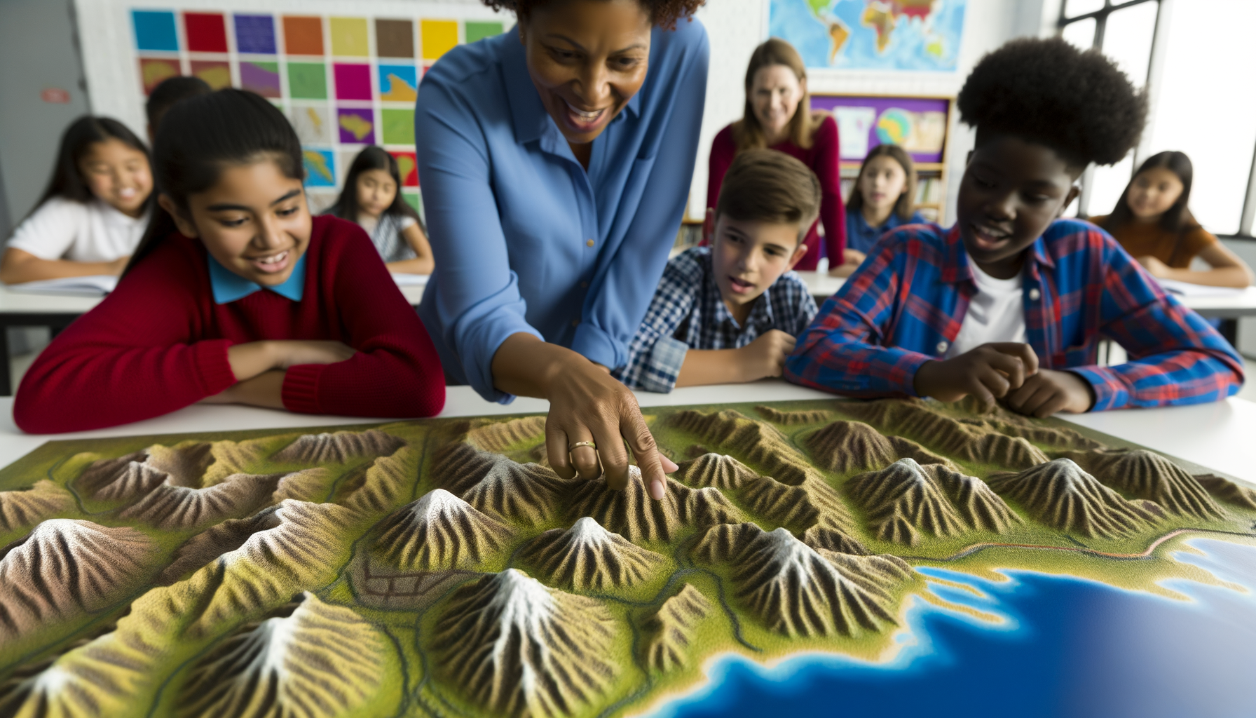
Raised relief maps, with their three-dimensional textures and contours, provide a unique and powerful alternative, engaging our sense of touch in a way that transforms abstract lines and colors into a concrete, understandable landscape.
For educators, students, individuals with visual impairments, and curious minds of all ages, these maps offer a distinct "tactile advantage" that significantly enhances learning and comprehension.
This post delves into the compelling reasons why incorporating raised relief maps into your learning journey or teaching toolkit can unlock deeper understanding, improve spatial reasoning, and make the study of geography and earth science more engaging and accessible than ever before.
We will explore what these maps are, the specific cognitive and educational benefits they offer, who stands to gain the most from using them, their diverse applications, a brief look at their history, and practical advice on choosing and using them effectively.
Discover how stepping away from the flat surface and feeling the world beneath your fingertips can profoundly change how you learn and understand geography.
What Exactly Are Raised Relief Maps?
At its core, a raised relief map is a cartographic representation that physically depicts the elevation of the terrain using variations in height.
Unlike standard two-dimensional maps that rely on contour lines, color shading, or hachures to indicate elevation changes, a raised relief map adds a third dimension, literally showing the ups and downs of the landscape.
This physical dimension makes mountains protrude, valleys indent, and plateaus stand out in a tangible way that flat maps cannot replicate.
They are often made from molded plastic or other durable materials, allowing users to feel the slopes, peaks, and depressions of the represented area.
While most commonly used for depicting landforms like mountain ranges, river valleys, and coastlines, the technique can theoretically be applied to subsurface features or even abstract data, though geographic elevation is their primary use.
How They're Made
The creation of raised relief maps typically involves a process called vacuum forming or injection molding.
First, a flat base map is printed with geographic details like political boundaries, cities, rivers, and roads.
Separately, a mold is created based on elevation data, often using digital models or historical techniques.
A heated sheet of plastic is then laid over this mold, and a vacuum is applied, pulling the plastic down to conform to the three-dimensional shape of the terrain.
Finally, the pre-printed flat map is carefully aligned and bonded to the molded plastic, creating the finished product where the flat geographic details align with the physical relief.
Modern techniques may also utilize 3D printing for creating highly detailed and custom relief models, offering even greater precision and flexibility in scale and representation.
The Core Advantage: Tactile Learning
The most significant benefit of raised relief maps lies in their ability to facilitate tactile learning, a powerful pedagogical approach that engages the sense of touch.
This multi-sensory engagement goes beyond visual input, creating richer and more memorable learning experiences.
Feeling the actual shape of a mountain range or tracing the path of a river valley with your finger provides a fundamentally different understanding than simply looking at lines on a page.
Engaging Multiple Senses
Learning is significantly enhanced when multiple senses are involved.
Raised relief maps engage not only vision but also touch, allowing learners to physically interact with the information.
This multi-sensory input stimulates different parts of the brain simultaneously, leading to stronger neural connections and improved information processing.
Combining the visual representation of political boundaries, cities, and water bodies with the tactile feel of the physical landscape creates a holistic understanding of a region.
Enhancing Spatial Understanding
Spatial reasoning—the ability to understand and mentally manipulate objects and their relationships in space—is crucial for geography, mathematics, science, and many other fields.
Raised relief maps are exceptional tools for developing this skill because they directly represent three-dimensional space in a physical form.
Feeling the height difference between a peak and a surrounding plain, understanding how rivers flow downhill, or seeing how a mountain range forms a natural barrier provides intuitive spatial understanding that flat maps struggle to convey.
Learners can develop a better mental model of the terrain, crucial for understanding concepts like watersheds, elevation profiles, and the impact of topography on climate and human settlement.
Improving Memory Retention
Active engagement, especially multi-sensory engagement, is strongly linked to better memory retention.
When learners physically interact with a raised relief map—tracing routes, identifying features by touch, comparing heights—they are creating a more memorable experience than passive viewing.
The tactile memory of feeling a steep slope or a winding river reinforces the visual and cognitive information associated with that feature.
This hands-on interaction helps to solidify information in long-term memory, making recall easier and more accurate later on.
Making Abstract Concepts Concrete
Concepts like elevation, contour lines, and watersheds can be abstract and difficult to grasp from flat representations alone.
Raised relief maps make these concepts concrete and tangible.
Feeling the physical rise of a mountain range immediately clarifies what "high elevation" means in that context.
Observing how water features are positioned within valleys reinforces the concept of drainage basins and watersheds in a way that diagrams or contour lines might not for all learners.
This tangibility helps bridge the gap between abstract representation and the physical reality of the landscape.
Who Benefits Most?
While raised relief maps offer advantages for nearly everyone studying geography, certain groups benefit particularly significantly from their unique tactile nature.
Their design inherently supports diverse learning needs and preferences.
Students (K-12, Higher Ed)
From elementary school children learning basic landforms to university students studying complex geological processes, raised relief maps provide invaluable support.
Younger students can physically explore concepts like mountains, hills, plains, and rivers, building a foundational understanding through play and touch.
Older students can use them to visualize more complex concepts such as glacial erosion patterns, tectonic plate boundaries (where they influence topography), or the strategic importance of terrain in historical events.
They cater especially well to kinesthetic learners and those who struggle with abstract visual information alone.
Individuals with Visual Impairments
Raised relief maps are perhaps one of the most crucial cartographic tools for people who are blind or have low vision.
They provide direct, independent access to geographic information that is otherwise inaccessible or difficult to interpret from standard maps.
By feeling the contours, shapes, and relative heights, individuals can build a mental map of a region, understand scale, and grasp geographical relationships just like a sighted person using a visual map.
Often, these maps are supplemented with Braille labels for political features and place names, further enhancing accessibility and independence in learning and exploration.
They are not just learning aids; they are essential tools for inclusion and equitable access to geographic knowledge.
Lifelong Learners and Hobbyists
Beyond formal education, raised relief maps are a wonderful resource for anyone with a passion for geography, hiking, travel, or history.
Planning a hiking trip becomes more insightful when you can feel the steepness of the trails and the elevation gain.
Understanding military campaigns or exploration routes is enhanced by physically tracing paths over mountainous or riverine terrain.
Simply exploring a map of a favorite national park or a far-off continent through touch can be a deeply satisfying and educational experience for personal enrichment.
Applications in Education and Beyond
The utility of raised relief maps extends across various disciplines and practical applications, making them versatile educational tools.
Their ability to make the physical world tangible opens doors to diverse learning activities.
Geography and Cartography
This is the most obvious application area, where raised relief maps are fundamental tools.
They are used to teach core concepts like landforms, topography, elevation, map projections (understanding distortion effects on relief), and the relationship between physical geography and political/human geography.
Students can learn to read and interpret contour lines on flat maps by comparing them to the actual physical features on a raised relief map of the same area.
Understanding relative elevation, slope, aspect (direction of slope), and how these factors influence drainage or visibility is greatly facilitated by the tactile experience.
Geology and Earth Science
For students of geology, raised relief maps are invaluable for visualizing geological structures and processes.
They can help illustrate concepts such as tectonic uplift, erosion by water or glaciers, volcanic landforms, and fault lines.
Examining the physical shape of mountain ranges formed by different geological processes or understanding how erosion carves out river valleys becomes much clearer when the student can touch the results of these forces.
They provide a tangible link between the abstract geological forces discussed in textbooks and the physical landscapes they shape.
History and Social Studies
Geography has always played a critical role in shaping human history, migrations, conflicts, and settlements.
Using a raised relief map, students can gain a deeper understanding of how terrain influenced historical events.
Why were certain trade routes chosen? How did mountains or rivers act as natural barriers or defenses? Why did settlements develop in particular locations?
Physically seeing and feeling the terrain of historical battlefields or ancient empires brings a new dimension to understanding strategic decisions and human movement throughout history.
Special Education and Inclusive Learning
As highlighted earlier, raised relief maps are powerful tools for inclusive education, particularly for students with visual impairments.
However, they also benefit students with learning disabilities, attention deficits, or those who simply learn better through hands-on interaction.
The tactile experience can help anchor information for learners who struggle with traditional visual or auditory methods.
They provide an alternative pathway to understanding complex spatial information, promoting engagement and success in geography and related subjects for a wider range of students.
Home Learning Environments
For parents homeschooling their children or simply wishing to supplement their child's learning, a raised relief map is an excellent investment.
Having a large, tactile map readily available encourages spontaneous exploration and questions about the world.
Children can trace journeys, identify features from books or news, and develop a concrete understanding of global or regional geography through casual, hands-on interaction.
It transforms geography from a subject confined to textbooks into a dynamic, explorable part of the home environment.
A Brief History of Raised Relief Maps
While modern raised relief maps benefit from advanced manufacturing techniques, the concept of depicting terrain in three dimensions has a history stretching back centuries.
Early attempts were often large, handcrafted models used for military planning or landscape design.
Early Concepts
Perhaps one of the earliest well-known examples is the 'Plan-relief' collection initiated in France in the 17th century, meticulous scale models of fortified cities and their surrounding landscapes used for strategic military purposes.
These were incredibly detailed and labor-intensive to create, essentially large-scale 3D topographic models rather than the more portable maps we know today.
Throughout the 18th and 19th centuries, mapmakers continued to experiment with techniques to represent elevation, often involving layered cardboard or plaster, but these were still primarily artistic or highly specialized creations, not mass-produced educational tools.
Technological Advancements
The development of vacuum forming technology in the mid-20th century revolutionized the production of raised relief maps.
This process allowed for the relatively inexpensive mass production of molded plastic maps, making them accessible to schools, universities, and the general public for the first time on a large scale.
Companies began producing maps of continents, countries, states, and specific regions, standardizing the scale and data used for the relief.
While digital mapping has become ubiquitous, the value of the physical, tactile experience provided by these historically significant maps has ensured their continued relevance in education and specialized applications.
Choosing the Right Raised Relief Map
Selecting the best raised relief map depends on your specific needs, target audience, and intended use.
Considering a few key factors will help you make an informed decision.
Scale and Detail
Raised relief maps come in various scales, from large global maps to highly detailed maps of small regions or even individual mountains.
Consider the level of detail you need.
A large-scale map (covering a smaller area in more detail) will provide more pronounced and accurate representation of smaller landforms like hills and valleys.
A small-scale map (covering a larger area like a continent or the world) will show major mountain ranges and plateaus but with less relative height difference and fine detail.
Often, the vertical scale (representing height) is exaggerated compared to the horizontal scale to make the relief more apparent, so understand the map's specifications.
Material and Durability
Most raised relief maps are made from durable, vacuum-formed plastic that can withstand frequent handling.
Some higher-end or historical models might use different materials.
If the map will be used in a classroom with many students or in a public space, durability is a critical factor.
Consider if it needs to be washable or resistant to bending and creasing.
Specific Region or Topic
Determine what geographic area or specific features you want to focus on.
Do you need a map of your local state or region, a specific national park, an entire continent, or the whole world?
Some maps specialize in showing specific features like ocean floors (bathymetric relief) or geological formations.
Choosing a map relevant to your curriculum, interests, or location will maximize its utility and engagement.
Accessibility Features
If the map is intended for individuals with visual impairments, ensure it includes accessibility features such as Braille labels for key locations, raised symbols for cities of different sizes, and clear tactile differentiation between land and water.
Not all raised maps are designed with these specific features, so check product descriptions carefully if accessibility is a primary requirement.
Integrating Raised Relief Maps into Learning
Acquiring a raised relief map is just the first step; effectively integrating it into teaching or learning activities is key to maximizing its potential.
These maps are not just display items; they are meant to be touched, explored, and discussed.
Hands-on Activities and Exercises
Encourage learners to physically interact with the map.
Ask them to close their eyes and identify different landforms by touch alone.
Have them trace the path of rivers from their source in the mountains to where they enter the sea, discussing the concepts of watershed and elevation change.
Use modeling clay or other materials to add features to the map or simulate geological processes like erosion in specific areas.
Compare the raised relief map side-by-side with a traditional flat map and discuss the differences in representation and the unique information each provides.
Combining with Digital Resources
Raised relief maps complement, rather than replace, digital mapping tools like Google Earth or online GIS platforms.
Use the raised map to build foundational spatial understanding, then transition to digital tools to view satellite imagery, gather data, or explore different map layers.
Show students a location on the physical raised map, then find the same location using a digital tool to see it from different perspectives (like satellite view or street view) and access additional information.
This blended approach leverages the strengths of both tactile and digital methods for a richer learning experience.
Encouraging Exploration and Discovery
Simply making a raised relief map available in a classroom, library, or home can spark curiosity.
Allowing free exploration lets learners discover features and ask questions organically.
Pose open-ended questions like "Why do you think the cities are located in the flatter areas?" or "How would traveling across these mountains be different from traveling across these plains?"
Let learners lead the exploration, following their fingers and their questions across the physical landscape of the map.
The Future of Tactile Cartography
While traditional raised relief maps have a long history, the field of tactile cartography continues to evolve, embracing new technologies to create even more detailed and accessible representations of the world.
Innovation is expanding the possibilities for tactile geographic data.
Digital Integration and 3D Printing
High-resolution digital elevation models (DEMs) are now widely available, allowing for the creation of highly accurate and detailed relief data.
This digital data can be directly used with 3D printers to create custom, highly detailed tactile maps of virtually any area on Earth.
3D printing allows for unprecedented flexibility in scale, detail, and the ability to highlight specific features, offering a personalized approach to creating tactile learning materials.
Combining GIS data with 3D printing technology opens up possibilities for creating tactile maps that overlay various data layers (like population density or climate zones) onto the physical terrain.
Enhanced Accessibility Features
Future developments are likely to focus on making tactile maps even more accessible and informative for individuals with visual impairments and other learning needs.
Integration of smart technology could lead to maps that provide auditory feedback when a feature is touched, identifying locations or providing descriptive information.
Standardization of tactile symbols and labeling conventions will improve usability across different map products.
Ongoing research into haptic feedback technology may also play a role, creating dynamic tactile experiences linked to digital data.
Conclusion: Embracing the Tangible World
In conclusion, while digital maps offer unparalleled convenience and access to vast amounts of data, raised relief maps provide a crucial, complementary learning experience.
Their tactile nature engages the sense of touch, offering a unique pathway to understanding the physical geography of our world.
This tactile advantage enhances spatial reasoning, improves memory retention, and makes abstract concepts tangible, benefiting students of all ages and learning styles, particularly individuals with visual impairments.
From classroom education in geography, geology, and history to personal exploration and professional planning, raised relief maps serve as powerful tools for deeper understanding.
As technology advances, the creation and accessibility of tactile maps will only improve, offering exciting possibilities for the future of geographic education.
Whether you are an educator looking to enrich your lessons, a parent seeking engaging learning resources, or a curious individual wanting to connect with the planet in a new way, exploring the world through the touch of a raised relief map offers a rewarding and insightful experience.
Step away from the screen for a moment and feel the contours of the Earth; you might be surprised at the depth of understanding you gain.