


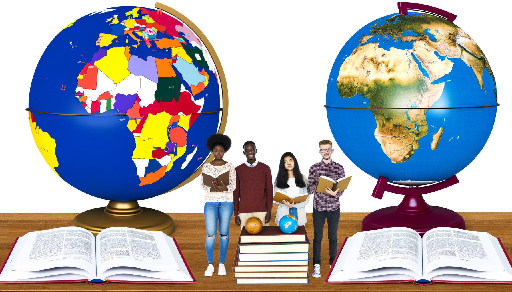
The Educational Value of Political vs. Physical Globes: Exploring Different Perspectives of Our World
Globes are timeless tools that capture the imagination and foster a fundamental understanding of our planet. More than just decorative spheres, they are powerful educational instruments, offering a tangible representation of the Earth that flat maps simply cannot replicate.
However, not all globes are created equal. The visual information they present can vary dramatically, primarily depending on whether they are designed as political or physical globes.
Understanding the fundamental differences between these two types is crucial for anyone seeking to maximize their educational impact, whether for a student in a classroom, a homeschooler, or simply a curious mind wanting to learn more about the world. This distinction goes beyond mere appearance; it represents two entirely different lenses through which we can view and comprehend the complex realities of Earth, encompassing both human civilization and the natural environment.
This post will delve deep into what defines political and physical globes, outlining the unique educational value each brings. We will compare their features, discuss the specific types of learning they support, and ultimately argue that while distinct, they offer the most comprehensive understanding when used together.
By the end, you will have a clear understanding of which type of globe suits specific learning goals and appreciate the rich, multilayered perspective that a combination of political and physical geography can provide, offering a comprehensive solution to enriching your geographical knowledge or that of your students.
Understanding the Political Globe: The Human Blueprint of Earth
A political globe is perhaps the most commonly recognized type, featuring the vibrant colors and distinct lines that demarcate the world's countries, their borders, and major cities. These globes are essentially a representation of human-defined territories and administrative divisions overlaid onto the spherical form of the Earth.
The primary focus of a political globe is the human landscape. It shows the geographical distribution of political power, sovereignty, and population centers.
You will find countries highlighted in different colors to make their boundaries clear, along with capital cities, major metropolitan areas, states, provinces, and sometimes even key transportation routes like major highways or shipping lanes.
What Information Does a Political Globe Provide?
The information presented on a political globe is directly relevant to the fields of civics, history, economics, and current events. It is a snapshot of the geopolitical reality of the world at the time the globe was produced.
Key elements typically found include country names, international borders, state or provincial borders within larger countries, capital cities (often marked with a star or special symbol), and other significant cities.
Oceans, seas, and major bodies of water are also labeled, but the emphasis remains firmly on the human organization of the landmasses.
The Educational Value of Political Globes
The educational benefits of using a political globe are numerous, particularly for understanding human geography and global affairs. They provide a concrete way to visualize abstract political concepts and relationships between nations.
Learning the names and locations of countries is a foundational aspect of global literacy, and a political globe makes this task intuitive and engaging. Students can see the relative size and position of different nations, helping them grasp concepts like proximity and geographical neighbors.
Furthermore, political globes are invaluable tools for teaching history. Historical events, such as the expansion and contraction of empires, the outcomes of wars, or the formation of new countries, can be traced and understood spatially by referencing a political globe.
Understanding current events also becomes much easier when you can immediately locate the countries and regions being discussed in the news. A political globe provides the essential geographical context for understanding international relations, conflicts, and global cooperation.
They help answer questions like: "Where is Ukraine in relation to Russia and Europe?" or "How does the geography of Southeast Asia influence trade routes?" These questions rely on understanding political boundaries and major population centers.
Ideal Use Cases for Political Globes
Political globes are essential resources in social studies classrooms, history lessons, and discussions about current events. They are perfect for teaching students about different forms of government, international organizations, and global demographics.
For anyone following world news, a political globe is an indispensable reference tool. It provides immediate orientation and helps connect distant events to a tangible location on Earth.
Travelers and those interested in global cultures also benefit greatly from political globes, using them to plan trips, understand distances between countries, and appreciate the diversity of human settlements across the globe.
Understanding the Physical Globe: Earth's Natural Tapestry
In contrast to political globes, physical globes focus on the natural features of the Earth's surface. They depict topography, showing mountains, valleys, plains, plateaus, deserts, and the depths of oceans and seas. These globes offer a view of the planet as nature shaped it, largely ignoring human-drawn lines.
The coloring on a physical globe typically represents elevation levels, often using shades of green for lowlands, brown and tan for higher elevations and mountains, and blues for water, with different shades indicating depth.
Some physical globes feature raised relief, allowing users to physically feel the mountains and valleys, adding a tactile dimension to geographical learning.
What Information Does a Physical Globe Provide?
The information on a physical globe is centered on geology, geomorphology, oceanography, and climate. It shows the structure and form of the Earth's crust and the vast bodies of water that cover most of its surface.
Key elements include major mountain ranges (like the Himalayas, Rockies, or Andes), extensive river systems (like the Amazon, Nile, or Mississippi), vast deserts (like the Sahara or Gobi), significant lakes, ocean basins, and sometimes features like oceanic ridges and trenches.
While large countries or continents might be outlined faintly for orientation, the focus is explicitly on the landforms and water bodies, not the political entities that inhabit them.
The Educational Value of Physical Globes
Physical globes are paramount for teaching physical geography, earth science, and environmental studies. They provide a fundamental understanding of the planet's natural systems and how they interact.
Visualizing mountain ranges and river systems on a sphere helps students understand concepts like watersheds, erosion, and how topography influences climate and weather patterns. Seeing the vastness and depth of oceans provides perspective on marine ecosystems and global currents.
Understanding plate tectonics and geological history is enhanced by seeing the arrangement of continents and major mountain belts, which often form along plate boundaries. A physical globe makes abstract geological concepts more concrete.
Furthermore, physical geography significantly impacts human activity and settlement. Understanding where mountains, deserts, or fertile plains are located helps explain historical migration patterns, the location of cities, and even political boundaries or conflicts over resources.
For instance, seeing the formidable barrier of the Himalayas on a physical globe helps explain why certain historical interactions between India and China developed differently than interactions across flatter landscapes. Similarly, locating major river systems on a physical globe illuminates why civilizations historically flourished along their banks.
Ideal Use Cases for Physical Globes
Physical globes are indispensable in science classrooms, particularly for geography, geology, and environmental science. They are excellent for teaching about landforms, ecosystems, and Earth's physical processes.
Meteorologists, climatologists, and environmental scientists use physical geography data extensively, and a physical globe provides a foundational visual aid for these fields.
Anyone interested in the natural world, hiking, climbing, or understanding ecological systems will find a physical globe endlessly fascinating and informative. It connects you directly to the physical structure of the ground beneath your feet and the water that shapes our climate.
Comparing and Contrasting: Two Views of the Same World
While both political and physical globes represent the same spherical Earth, the information they prioritize creates two very different visual and educational experiences. The core difference lies in their focus: human constructs versus natural formations.
A political globe is dynamic; its information changes over time as countries form, dissolve, or change borders. It reflects the constantly evolving state of human society on Earth.
A physical globe, while also subject to change over geological timescales, presents a much more stable, enduring picture of the planet's fundamental structure. Mountains rise and erode, but the major ranges and ocean basins persist for millennia, reflecting Earth's deep history.
Visual Representation
The most immediate difference is visual. Political globes use sharp lines and distinct, often contrasting colors to delineate countries. Cities are points or symbols.
Physical globes use gradients of color and sometimes texture (in raised relief versions) to show elevation and bathymetry. Landforms are represented by their shape and height or depth, not by political division.
Core Information Focus
Political globes prioritize names of countries, capitals, and cities, along with the invisible lines of borders. They tell you where people have decided to draw lines and organize themselves.
Physical globes prioritize names of mountains, rivers, deserts, oceans, and other natural features. They tell you about the shape of the land and the distribution of water.
Educational Emphasis
The educational emphasis follows the focus. Political globes are tailored for social studies, history, and political science, teaching the geography of human civilization.
Physical globes are tailored for physical geography, geology, oceanography, and environmental science, teaching the geography of Earth's natural systems.
Neither globe is inherently "better" than the other; they simply serve different purposes and provide different, essential kinds of information about our planet. Using only one type of globe provides an incomplete picture of the Earth and its complexities.
The Synergistic Value: Why Both Globes Are Better Together
While political and physical globes offer distinct perspectives, their true power is unlocked when they are used in conjunction. The human story unfolds upon a physical stage, and understanding that stage is critical to understanding the story.
Many geographical realities are a result of the interplay between political decisions and physical constraints or opportunities. For example, rivers often form natural political boundaries. Mountain ranges can isolate populations or act as defensive barriers, influencing the course of history and the formation of nations.
The location of major cities is frequently tied to physical features like navigable rivers, fertile plains, natural harbors, or proximity to vital resources found in specific geological formations.
Connecting Human and Natural Worlds
Using both a political and a physical globe allows for a deeper, more nuanced understanding of these connections. You can locate a country on a political globe and then switch to a physical globe to see the terrain within its borders. Is it mountainous, covered in forests, or dominated by desert?
This comparison helps answer crucial "why" questions in geography: Why is agriculture concentrated in certain regions? Why were some areas harder to conquer historically? Why are certain parts of the world more densely populated than others?
For example, observing the vast Amazon rainforest on a physical globe alongside the political boundaries of the countries it spans (Brazil, Peru, Colombia, etc.) on a political globe highlights both the immense scale of the ecosystem and the political challenges involved in its preservation.
Similarly, looking at the Nile River system on a physical globe and then seeing how countries like Egypt, Sudan, and Ethiopia lie along its course on a political globe illuminates the historical and ongoing geopolitical significance of shared water resources.
By using both types, learners gain a comprehensive understanding of how geography shapes human events and how human actions impact the environment. This integrated perspective is essential for developing true geographical literacy in the 21st century.
Choosing the Right Globe(s) for Your Needs
Selecting a globe or globes depends on your specific educational goals, the age of the learner, and practical considerations like space and budget. There is no single "best" globe for everyone.
However, understanding the strengths of political and physical globes allows you to make an informed decision. Often, having access to both, or even a dual-purpose globe (one that shows political boundaries when not illuminated and physical features when lit) is the ideal solution for comprehensive learning.
Key Considerations When Choosing:
When deciding which globe is right for you or your students, keep the following points in mind:
1. Identify Your Primary Learning Objective: Are you focused on international relations and country identification (political), or are you interested in landforms, climate, and geology (physical)? This is the most crucial factor.
2. Consider the Learner's Age and Grade Level: Younger children might start with a simpler political globe to learn country names. Older students studying earth science or history will benefit more from a physical globe, a detailed political globe, or both.
3. Evaluate Features Like Raised Relief and Illumination: Raised relief on physical globes provides a valuable tactile learning experience. Illuminated globes can sometimes offer a dual view (political vs. physical) or simply make details easier to see.
4. Think About Size and Durability: Globes come in various sizes. A larger globe shows more detail but requires more space. For classroom or frequent handling, consider durability.
5. Factor in Budget: Globes range in price depending on size, features, and materials. Determine what fits your budget while still meeting your educational needs.
If possible, investing in both a political and a physical globe, or a good quality dual-purpose globe, offers the most robust foundation for geographical learning.
Incorporating Globes Effectively into Learning
Owning a globe is just the first step; actively using it is key to unlocking its educational potential. Globes should be interactive tools, not just static decorations.
Here are some ways to integrate political and physical globes into learning activities:
Activities with Political Globes:
Use scavenger hunts to locate countries, capitals, or major cities mentioned in textbooks or the news. Trace the routes of famous explorers or historical migrations. Discuss current events, pinpointing the locations and understanding the political context.
Compare the sizes of countries at different latitudes to counter the distortion found on many flat maps (Mercator projection). Explore concepts like time zones and the International Date Line.
Activities with Physical Globes:
Identify and name major mountain ranges, deserts, and river systems. Trace the path of a major river from its source to the ocean. Discuss how landforms might affect climate or create natural barriers.
Use a string to measure the shortest distance (great circle route) between two points, like major cities, demonstrating why air travel often follows curved paths on a flat map.
Using Both Globes Together:
As mentioned earlier, compare the physical landscape of a country or region (on the physical globe) with its political divisions and population centers (on the political globe). Discuss how geography influenced historical events, settlement patterns, or resource distribution.
Research a specific region, using the physical globe to understand its environment and the political globe to understand its human inhabitants and challenges.
Globes as Part of a Larger Toolkit:
Globes work best when used alongside other geographical resources. Compare the information on a globe to flat maps (like a Mercator projection and a Robinson projection) to discuss the distortions inherent in 2D representations.
Use atlases, online mapping tools (like Google Earth), and geographical databases to supplement the information found on the globe, adding layers of detail about demographics, climate data, or historical information.
Making globes accessible and incorporating them into discussions and activities transforms them from passive objects into dynamic learning aids.
Conclusion: Towards a Holistic View of Our World
The distinction between political and physical globes highlights the two primary ways we categorize and study our planet: through the lens of human organization and through the lens of natural processes.
Political globes are invaluable for understanding the world of nations, borders, and human populations – the dynamic landscape of civilization and current affairs.
Physical globes are essential for comprehending the Earth's enduring natural features – the mountains, rivers, oceans, and landforms that constitute the stage upon which the human story unfolds and which significantly influence life on Earth.
Neither perspective is complete on its own. A truly comprehensive understanding of geography, history, and current events requires appreciating both the political boundaries humans have drawn and the physical realities of the land and water that shape our planet.
By utilizing both types of globes, educators and learners can gain a richer, more interconnected view of the world, recognizing how human and natural systems constantly interact. Investing in and actively using both political and physical globes is an investment in a deeper, more informed global awareness.
In an increasingly interconnected world facing complex challenges that span political borders and are influenced by environmental factors, a strong foundation in both political and physical geography is not just valuable – it is essential. Globes provide a powerful, tangible starting point for this lifelong learning journey.