


For many hikers, a map is an indispensable tool. It's the key to understanding your location, navigating trails, and appreciating the scale of the landscape around you.
While traditional flat topographic maps provide essential information like contour lines, trails, and waterways, they require a certain level of skill and interpretation to truly visualize the terrain's undulations.
Imagine being able to literally feel the mountains rise and the valleys fall beneath your fingertips, seeing the steepness of a slope or the depth of a canyon with intuitive clarity.
This is the power of a National Park raised relief map, a unique and incredibly valuable resource for any serious hiker looking to deepen their understanding of the landscape and enhance their planning.
This guide will delve into the world of these fascinating 3D maps, explaining what they are, highlighting their specific benefits for hikers, providing criteria for choosing the best one, and offering tips on how to incorporate them into your hiking routine.
Whether you are planning a challenging backcountry trek or simply want a better grasp of the park's geography, a raised relief map offers a perspective flat maps simply cannot match, providing a tangible solution to visualizing complex terrain.
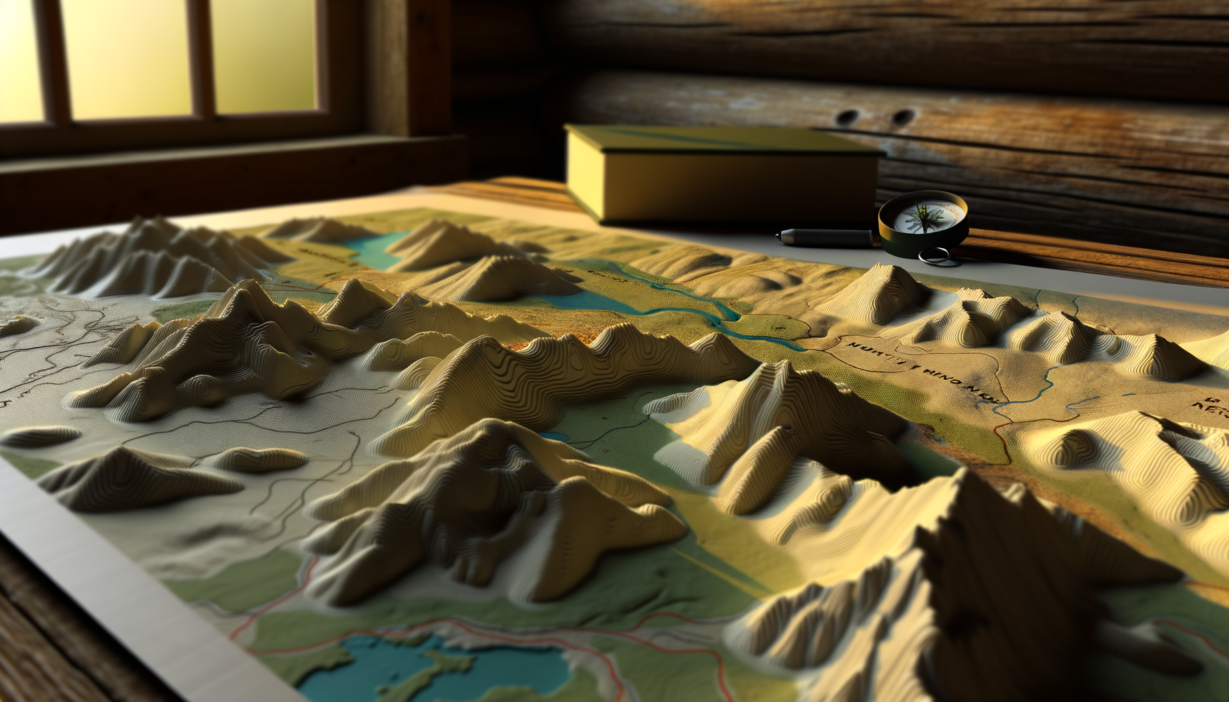
What Exactly are Raised Relief Maps?
Raised relief maps are three-dimensional representations of the Earth's surface, designed to visually and tactilely communicate the shape and elevation of the terrain.
Unlike standard flat maps printed on paper or digitally displayed on a screen, these maps literally pop out, mirroring the mountains, hills, valleys, and other landforms they depict.
The process typically involves printing a high-quality topographic map onto a sheet of plastic, which is then heated and vacuum-formed over a mold that replicates the terrain's elevation data.
This creates a physical model where changes in elevation are represented not just by lines and colors, but by actual changes in the map's surface height.
While the vertical scale is often exaggerated compared to the horizontal scale to make subtle elevation changes more apparent and dramatic, the relative proportions between different features are generally preserved, offering a powerful visual and tactile understanding of the landscape's structure.
The Science Behind the Shape
Creating an accurate raised relief map is a blend of art and science, combining precise geographic data with manufacturing techniques.
High-resolution elevation data, often derived from sources like LiDAR (Light Detection and Ranging) or photogrammetry, is crucial for generating the base mold.
This digital elevation model (DEM) provides the precise height information needed to shape the map's surface accurately.
The topographic information – trails, roads, rivers, boundaries, and other map features – is then printed onto the plastic sheet with incredible detail, ensuring that it aligns perfectly with the underlying molded shape.
The vacuum-forming process pulls the heated plastic down over the mold, creating the final three-dimensional product that brings the flat data to life.
Understanding this process helps appreciate the craftsmanship and data precision that goes into creating these remarkable tools.
Why Raised Relief Maps are Invaluable for Hikers
While a flat map is essential for navigation, a raised relief map offers unique advantages that significantly enhance the hiking experience, both in planning and appreciation.
These benefits stem directly from their three-dimensional nature, providing insights that contour lines alone can sometimes obscure for the untrained eye.
For anyone serious about exploring national parks and understanding their geographical challenges and beauty, a raised relief map is more than just a novelty; it is a powerful analytical and planning tool.
They transform abstract data into a tangible reality, making the complex terrain of national parks more accessible and understandable before you even hit the trail.
Unparalleled Terrain Visualization
One of the most significant advantages of a raised relief map is its ability to provide an intuitive sense of the terrain's shape and steepness.
You can immediately see how a mountain range rises from a valley, the depth of a canyon, or the grade of a ridge.
This visual and tactile understanding helps you comprehend the layout of the land in a way that interpreting contour lines on a flat map often cannot fully replicate.
Seeing the actual three-dimensional form makes it easier to identify key landforms, understand drainage patterns, and visualize the overall structure of the park's geography.
This intuitive grasp of topography is crucial for anticipating challenges and appreciating the geological forces that shaped the landscape.
Seeing the Steeps and the Flats
With a raised relief map, the effort required for a hike becomes much clearer.
Steep slopes are visually evident as sharp changes in elevation on the map's surface, while flat areas appear as level expanses.
This immediate visual feedback is far quicker and often more accurate for hikers than mentally calculating slope percentages from contour line spacing.
You can quickly identify major ascents and descents along a potential route simply by looking at and touching the map.
This helps in realistically assessing the physical demands of a trail and planning your hike accordingly, potentially avoiding unexpectedly difficult sections or finding gentler alternatives.
Enhanced Route Planning
Having a clear visualization of the terrain directly translates into more effective route planning.
You can trace potential trails and immediately see how they interact with the topography – whether they follow ridges, traverse steep slopes, drop into valleys, or wind around obstacles.
This helps identify potential bottlenecks, exposed sections, or areas prone to switchbacks before you even leave home.
Understanding the flow of the land makes it easier to anticipate where water might collect, where views are likely to open up, or where you might find shelter.
Using a raised relief map alongside a detailed flat map allows for a more informed decision-making process when choosing your hiking path.
Identifying Strategic Points
Raised relief maps excel at helping you spot strategic points on the landscape.
Prominent peaks, distinctive saddles, major river crossings, or significant cliffs are immediately apparent.
Identifying these features during planning makes them easier to recognize in person, aiding navigation on the trail.
You can use the map to identify potential viewpoints along a ridge or find a sheltered spot for a break in a specific valley.
This detailed understanding of the terrain allows for more nuanced and strategic planning than simply following a line on a flat surface.
Improved On-Trail Orientation
While you likely won't carry the entire raised relief map on the trail (they are often bulky!), the familiarity gained during planning is invaluable for orientation.
Having seen and felt the major landforms in three dimensions, you are much better equipped to recognize them when you encounter them in the real world.
Spotting a distinct peak or a particular valley shape that you studied on your relief map can help confirm your position and understand the surrounding geography.
This mental model of the terrain, built through interacting with the 3D map, complements your use of a flat map or GPS on the trail.
It adds a layer of spatial understanding that can be crucial when navigating complex or unfamiliar areas within the park.
A Deeper Connection to the Landscape
Interacting with a raised relief map fosters a more profound connection to the national park's geography.
Touching the mountains and tracing the rivers provides a tactile link to the physical reality of the place you are exploring or plan to visit.
It brings the abstract representation of a flat map into the realm of the tangible and immediately understandable.
This deeper engagement enhances anticipation before a trip and allows for richer reflection afterward, helping you recall and visualize the terrain you traversed.
Many hikers find that owning a raised relief map of a beloved park becomes a cherished piece of art and a constant source of inspiration for future adventures.
Excellent Educational Tool
Raised relief maps are superb educational resources for hikers of all ages and experience levels.
They make it easy to explain the concepts of elevation gain, watershed areas, or the formation of specific geological features.
Showing children or new hikers the actual shape of a mountain or canyon on a 3D map is far more impactful than pointing to contour lines.
They help illustrate how trails are routed to navigate challenging terrain and the impact of topography on ecosystems and weather patterns.
Using these maps can turn trip planning sessions into engaging lessons about geography and conservation.
Choosing the Best Raised Relief Map for Your Adventures
Selecting the right raised relief map involves considering several factors to ensure it meets your specific needs and enhances your hiking experience.
Not all raised relief maps are created equal, and features like scale, coverage, and overall quality can vary significantly between publishers and specific maps.
Taking the time to evaluate these criteria will help you invest in a map that will be a valuable tool and a source of inspiration for years to come.
Consider how you plan to use the map – primarily for wall display and general understanding, or specifically as a detailed planning tool for specific hikes.
Thinking through these points will guide you towards the best fit for your personal connection with national parks.
Map Scale and Detail Level
The scale of a map determines the level of detail it can display and the size of the area it covers.
A larger scale map (e.g., 1:24,000 or 1:50,000) covers a smaller geographic area but shows much more detail, including minor trails, streams, and specific rock formations.
A smaller scale map (e.g., 1:100,000 or 1:250,000) covers a larger area but provides less detail, showing major features and principal trails.
For detailed hike planning, a larger scale map is generally more useful, allowing you to see the relationship between individual trails and localized terrain features.
For general park understanding and wall display, a smaller scale map covering the entire park might be sufficient, offering a comprehensive overview of its geography.
Coverage Area
Consider what specific area of the park or region you need the map to cover.
Some raised relief maps cover an entire national park, while others focus on a specific, popular district within a larger park (like the Yosemite Valley or the Grand Canyon's South Rim).
If you primarily hike in one specific area, a detailed map of that section might be preferable to a less detailed map of the whole park.
However, if you explore different areas or want an overall understanding, a full-park map is the way to go.
Ensure the map covers the trailheads and routes you are most interested in exploring, verifying its boundaries before purchasing.
Physical Size and Material
Raised relief maps are typically made from durable vacuum-formed plastic, but their physical size varies greatly.
Some are large wall maps, perfect for displaying and planning at home, but impractical for carrying.
Others are smaller formats, potentially suitable for transport but still bulkier than a folded paper map.
Consider where you will store and use the map; a large map might require significant wall space, while a smaller one is more portable.
The plastic material is generally robust and water-resistant, making them quite durable for repeated handling and planning sessions.
Accuracy and Vertical Exaggeration
Accuracy is paramount for any map used for planning.
Look for maps from reputable publishers known for their cartographic quality and use of accurate elevation data.
Vertical exaggeration is a common feature of raised relief maps, where the vertical scale is stretched relative to the horizontal scale to make the topography more visually dramatic and easier to perceive.
Understand that this exaggeration exists and may vary between maps; it's important for visualization but means you shouldn't directly measure angles of slope from the map's surface without accounting for it.
The legend or accompanying information should ideally state the ratio of vertical exaggeration used.
Map Aesthetics and Information
Beyond the 3D shape, the quality of the printed map itself is crucial.
Check the clarity of the printing, the readability of labels, and the comprehensiveness of the legend.
A good map should clearly depict trails, roads, water bodies, park boundaries, campgrounds, and points of interest.
Colors should be clear and distinguishable, and text should be easy to read, even on the contoured surface.
A map that is both aesthetically pleasing and information-rich will be a joy to use and display.
Cost Consideration
Raised relief maps are generally more expensive than standard flat maps due to the specialized manufacturing process.
Prices can vary based on size, detail, and publisher.
Determine your budget, but also consider the value the map provides in terms of enhanced planning, understanding, and long-term appreciation.
Think of it as an investment in your connection to the park and your preparedness for exploring its terrain.
While they are an investment, the insights and enjoyment they provide often justify the cost for dedicated hikers and park enthusiasts.
Tips for Using Your Raised Relief Map Effectively
Acquiring a raised relief map is just the first step; using it strategically will unlock its full potential for your hiking adventures.
These maps are best utilized as part of a comprehensive planning toolkit, complementing other resources rather than replacing them entirely.
Integrating your raised relief map into your pre-trip preparation can significantly improve your confidence and understanding of the terrain you will encounter.
Thinking beyond just looking at the map and actively using it to visualize and plan will yield the greatest benefits.
Here are some practical tips to help you get the most out of your three-dimensional park map.
Pre-Trip Planning is Key
The most effective way to use a raised relief map is during the planning phase of your trip.
Spend time with the map before you go, tracing potential routes with your finger and observing how the trail interacts with the terrain.
Identify major elevation changes, potential switchbacks, and areas where you might experience significant exposure or find water sources.
Use the map to pinpoint prominent landmarks you can look for on the trail for orientation.
Visualize the views you might expect from different elevations and the effort required to reach them.
Combine with Other Essential Tools
A raised relief map is a powerful visualization aid, but it should be used in conjunction with other reliable navigation tools.
Always carry a detailed, current flat paper map and a compass while hiking; know how to use them even if you primarily rely on digital navigation.
Digital mapping apps and GPS devices are also excellent resources, providing real-time location tracking and detailed route information.
Use your raised relief map to gain a conceptual understanding of the terrain, then use your flat map or digital tools for precise navigation, distances, and current conditions.
Each tool offers different strengths, and using them together provides the most robust approach to trail safety and navigation.
Reference During Downtime
While carrying a large raised relief map on trail is usually impractical, the insights gained from studying it intensely before your trip remain with you.
However, if you are basecamping or staying in a park lodge, a smaller, more portable relief map of the immediate area can be an interesting reference during downtime.
Use it to reflect on the day's hike, identify the peaks you saw, or plan the next day's adventure with a clear visual understanding of the upcoming terrain.
Even just revisiting the map back at camp reinforces your understanding of the park's geography and enhances your appreciation of your surroundings.
It serves as a constant, tangible link between your experience on the trail and the broader landscape.
Teach and Share the Experience
Use your raised relief map as a teaching tool for hiking partners, family, or friends.
It makes explaining routes, potential challenges, and geographical features incredibly intuitive.
Showing someone the actual incline of a trail or the depth of a canyon on the 3D map is far more effective than describing it.
This not only educates others but also reinforces your own understanding of the park's layout.
Sharing the map creates a shared visual language for your adventure planning and post-hike reflections.
Where to Purchase National Park Raised Relief Maps
Finding a high-quality raised relief map for a specific national park requires knowing where to look, as they are not as widely available as standard paper maps.
Several reputable sources specialize in producing and distributing these unique cartographic products.
Exploring these options will increase your chances of finding the perfect map for the national park you are interested in.
It's always a good idea to check the publisher's reputation and reviews before making a purchase to ensure accuracy and quality.
Consider convenience, selection, and the ability to see the map's detail before buying, if possible.
Specialty Map Retailers and Publishers
Several companies specialize in creating and selling raised relief maps, including those for national parks.
Publishers known for quality topographic maps sometimes also produce raised relief versions of popular areas.
Searching online for "raised relief maps [National Park Name]" will often lead you to these dedicated map sellers.
Websites of these specialty retailers often provide detailed specifications about the map's scale, coverage, and physical dimensions.
Buying directly from or through a specialty map provider often ensures you are getting a product from a company with expertise in cartography.
National Park Visitor Centers and Stores
Many large and popular national parks sell raised relief maps specific to their area in their visitor center bookstores or park stores.
These are often published by official park partners or reputable map companies contracted by the park.
Purchasing directly from the park supports park operations and conservation efforts.
This is an excellent option because you can often see the map in person before buying and ensure it meets your expectations.
Availability can vary, so it may be worth calling ahead if you are making a special trip just to purchase a map.
Museum Shops and Educational Retailers
Science museums, natural history museums, and educational supply retailers sometimes carry raised relief maps, including those of prominent national parks or geographical regions.
These retailers often focus on educational tools and high-quality products.
Their selection might be limited, but they can be a source for well-produced and accurate maps.
Check the gift shops of major museums located near the national park you are interested in, as they might stock relevant maps.
Online educational suppliers can also be a source for these types of maps.
Online Marketplaces
General online marketplaces like Amazon or eBay also list raised relief maps from various sellers.
While convenient, it is crucial to be more cautious when buying from these platforms.
Always check the seller's reputation, read reviews, and verify the publisher's name and the map's specifications.
Counterfeit or low-quality maps can sometimes appear on these sites, so diligence is required.
Look for listings that clearly state the publisher, scale, and condition of the map.
Highly Recommended National Park Raised Relief Maps (Examples of Parks Where They Excel)
While recommending specific map products can be challenging due to varying availability and editions, we can highlight types of national parks where a raised relief map proves particularly beneficial and suggest attributes to look for.
Parks with significant topographic variation are where these maps truly shine, offering insights that are difficult to glean from flat representations alone.
Looking for maps of these types of parks, from reputable publishers, is a great starting point in your search.
Consider the geological features that define the park and how a 3D map could enhance your understanding of them.
Here are examples of park types and what makes their relief maps stand out.
Maps for Parks with Dramatic Elevation and Canyons
Parks like Grand Canyon, Zion, Yosemite, and many others in the American West feature incredible vertical relief.
Raised relief maps of these parks immediately show the immense depth of canyons, the steepness of valley walls, and the height of towering peaks.
For Grand Canyon, visualizing the layers and the descent/ascent required for rim-to-river hikes is powerfully conveyed.
In Yosemite, seeing the sheer granite walls and the U-shaped valley carved by glaciers becomes strikingly clear.
Look for maps that accurately capture these dramatic vertical features and clearly show the trail systems navigating them.
Maps Covering Complex Mountain Ranges
National Parks like Rocky Mountain, Great Smoky Mountains, Shenandoah, and sections of Glacier National Park feature intricate networks of interconnected peaks, ridges, and valleys.
A raised relief map helps hikers understand the relationship between these features, how drainage patterns flow, and how trails traverse or follow the spine of ranges.
You can see how one valley connects to another via a pass or how trails wind their way up multi-peaked summits.
These maps are excellent for planning multi-day traverses or understanding the vastness and connectivity of the mountain landscape.
Seek maps that clearly label individual peaks and passes and show the dense network of trails within the range.
Maps Highlighting Unique Geological Formations
Some parks are defined by unusual and striking geology, like Bryce Canyon's hoodoos, Capitol Reef's Waterpocket Fold, or Hawaii Volcanoes' volcanic landscapes.
Raised relief maps can provide a fantastic visualization of these unique formations.
Seeing the sculpted shapes of hoodoos or the overall bulge and flow of volcanic terrain in three dimensions offers insights into their formation and how trails navigate around them.
These maps are often as much educational tools as they are planning aids, helping visitors appreciate the forces that shaped these singular places.
Maps that use color and shading effectively alongside the relief can further highlight these distinct geological features.
What to Look for in a "Recommended" Map
Regardless of the park, a highly recommended raised relief map will generally possess a few key qualities.
It will be produced by a reputable publisher with a history of accurate cartography.
The plastic molding will be precise and align well with the printed map information.
The map detail – trails, contour lines (even if subtle on the relief), water, boundaries – will be clear and up-to-date.
Vertical exaggeration will be present but reasonable, clearly noted in the legend, and aid rather than distort visualization.
Finally, the map will be durable enough to withstand regular handling during planning.
Conclusion
National Park raised relief maps offer a truly unique and valuable perspective for hikers and outdoor enthusiasts.
They bridge the gap between the abstract representation of a flat map and the physical reality of the terrain, providing an intuitive, tactile understanding of the landscape.
Their benefits for planning, visualization, and fostering a deeper connection to the park are undeniable.
While not a replacement for essential flat maps and navigational tools on the trail, they are an unparalleled resource for pre-trip preparation and post-hike reflection.
Investing in a high-quality raised relief map of a national park you love or plan to explore extensively will undoubtedly elevate your understanding and enjoyment of its natural wonders.
So, take the plunge, feel the mountains, trace the valleys, and see your favorite national parks in a whole new dimension, making every planned step a more informed and engaging one.