


Connect Visually to Mountains: Explore Like Never Before with TESTPLAY Maps
The allure of mountains is undeniable. Their sheer scale, dramatic landscapes, and the sense of adventure they inspire draw millions to their slopes each year.
Whether you are a seasoned climber, a dedicated hiker, an armchair explorer, or someone who simply finds solace in gazing at distant peaks, there is a deep-seated desire to understand and connect with these majestic natural formations.
Traditional maps have long been essential tools, providing vital information about routes, elevations, and distances, but they often fall short of conveying the true visual nature of mountain terrain, leaving a gap between planning and the often breathtaking reality.
This challenge of translating flat, abstract lines into a tangible, visual understanding can impact everything from safety and preparation to the depth of appreciation for the environment around you.
Imagine being able to truly *see* the steepness of a slope before you commit to it, visualize the winding path of a trail over undulating terrain, or identify distant summits just by looking at them on a detailed map interface.
This level of visual connection is precisely what is needed to move beyond basic navigation and foster a profound relationship with the mountain environment.
This is where TESTPLAY Maps revolutionizes your interaction with the world's mountain ranges.
It is not just a mapping application; it is a powerful platform designed to bridge the gap between data and visualization, offering an unparalleled opportunity to connect visually with mountains in a way that static maps simply cannot.
TESTPLAY Maps provides the solution by offering rich, interactive, and multi-layered visual data that allows you to explore, plan, and experience mountains with a depth and clarity previously unavailable, transforming how you prepare for adventures, navigate in the wilderness, and reflect on your experiences.
It empowers you to see the mountain, understand its contours, appreciate its scale, and feel a connection that goes beyond just following a line on a page.
Why Connecting Visually to Mountains Matters
Our eyes are our primary tools for understanding the physical world around us.
When it comes to complex, three-dimensional environments like mountains, the ability to visualize terrain is not just helpful; it is crucial for a multitude of reasons.
A strong visual connection to the landscape enhances safety, improves planning efficiency, and significantly deepens the overall outdoor experience.
Being able to look at a map and truly *see* the ridges, valleys, and changes in slope allows you to anticipate challenges, choose appropriate routes, and make informed decisions in real-time.
It helps you identify potential hazards like steep drop-offs or avalanche-prone areas that might not be immediately obvious from contour lines alone.
Visualizing the landscape also plays a massive role in mental preparation.
By seeing the route laid out over realistic terrain, you can mentally prepare for the physical effort required and build confidence before even setting foot on the trail.
Furthermore, a deep visual understanding of the mountain environment fosters a greater sense of appreciation and wonder.
Recognizing specific geological features, understanding how water has carved valleys, or seeing the tree line's relationship to altitude connects you more intimately with the natural processes that shaped the landscape.
For landscape photographers, climbers planning ascents, or even hikers seeking the best viewpoint, visualizing the perspective and line of sight is paramount.
It moves mapping from a purely navigational task to an act of exploration and learning, allowing you to see the mountain not just as a collection of paths and peaks, but as a dynamic, visually rich entity.
Introducing TESTPLAY Maps: Your Window to the Peaks
At its heart, TESTPLAY Maps is built on the fundamental idea that seeing is understanding.
It moves beyond the limitations of traditional two-dimensional maps to offer a rich, interactive visual experience tailored specifically for mountain environments.
The platform integrates high-resolution satellite imagery, detailed topographical data, and advanced rendering technologies to create a dynamic, realistic representation of the world's mountain ranges.
Unlike standard mapping tools that might offer a satellite view as a simple overlay, TESTPLAY Maps weaves together multiple data sources to provide context, depth, and an intuitive visual connection to the terrain.
It is designed for anyone who loves mountains – from those planning their next multi-day trek to individuals simply curious about the topography of a distant range they admire from afar.
The interface is built to be both powerful and accessible, allowing users to fluidly pan, zoom, and tilt the perspective to view mountains from any angle, gaining insights that are simply impossible with flat maps.
Think of it as having the mountain range right there in front of you, available for close inspection from every conceivable viewpoint, enabling a level of pre-trip reconnaissance and on-mountain awareness that significantly enhances the entire adventure.
TESTPLAY Maps represents a new generation of mapping tools where the emphasis is placed squarely on the visual experience, fostering a deeper appreciation and understanding of the complex, beautiful world of mountains.
Core Visual Features of TESTPLAY Maps
TESTPLAY Maps distinguishes itself through a suite of features specifically designed to enhance visual connection with mountain landscapes.
These tools work together to provide a comprehensive and intuitive way to explore, understand, and interact with mountainous terrain before, during, and after your adventures.
Each feature is crafted to translate complex geographical data into easily digestible and visually stunning representations, ensuring you gain the most insights from the maps.
From understanding the nuances of elevation changes to seeing the actual texture of the earth from above, the visual information provided by TESTPLAY Maps is unparalleled.
Let's delve into the key features that make this platform an essential tool for any mountain enthusiast.
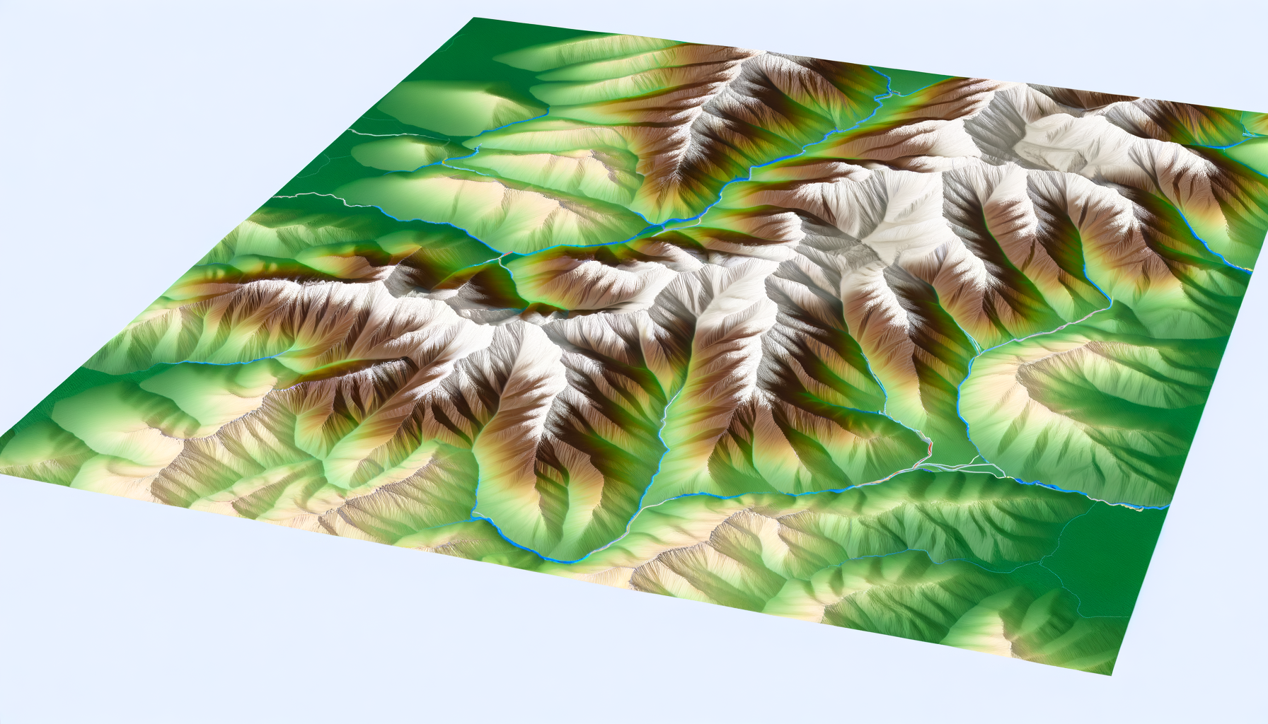
Unrivaled Topographical Detail Visualized
Topography – the study of the shapes and features of the earth's surface – is fundamental to understanding mountains.
Traditional maps use contour lines, which are abstract representations of elevation, requiring practice and interpretation to fully grasp the terrain.
TESTPLAY Maps transforms this data into highly intuitive visual formats.
It offers stunning 3D terrain rendering, allowing you to see the mountains rise and fall before your eyes with realistic shading that highlights slopes and features.
You can rotate the landscape, tilt the view, and zoom in to examine specific areas, getting a tangible sense of the steepness and complexity of the terrain.
Furthermore, TESTPLAY Maps includes advanced slope analysis visualizations.
This feature color-codes the map based on gradient, making it instantly clear where the terrain is gently sloped and where it becomes dangerously steep, a critical visual aid for route selection and avalanche risk assessment.
Different base layers emphasize topographical features in various ways, allowing users to choose the visualization style that best suits their needs, whether it's a classic contour map with enhanced 3D effect or a purely visual shaded relief representation.
This level of detail and visual flexibility ensures that the abstract data becomes concrete and understandable.
Breathtaking Satellite and Aerial Perspectives
While topographical maps show elevation, satellite and aerial imagery show the real world – the forests, rock faces, snowfields, and human structures.
TESTPLAY Maps integrates high-resolution satellite imagery seamlessly with its terrain data, providing a photo-realistic view of the mountains.
This imagery is often updated and processed to provide maximum clarity and detail, allowing you to identify specific features like boulder fields, dense tree cover, or the exact line of a ridge.
Beyond simple overhead views, TESTPLAY Maps often allows for oblique or perspective views, mimicking what you would see from an airplane or a high vantage point.
This perspective is incredibly valuable for understanding scale, identifying landmarks from a distance, and visualizing how different parts of the landscape connect.
Combining this imagery with the 3D terrain rendering provides an incredibly immersive experience.
You are not just looking at a picture; you are exploring a realistic 3D model overlaid with current, high-resolution ground truth, making the visual connection incredibly powerful and informative.
Dynamic Route Planning and Visualization
Planning a route in the mountains involves more than just plotting points on a map; it is about understanding the journey through the terrain.
TESTPLAY Maps excels here by offering dynamic route planning tools that are deeply visual.
As you plot a route, the line is drawn directly onto the 3D terrain model, allowing you to see precisely how the path traverses slopes, crosses valleys, and navigates around obstacles.
Accompanying the route visualization is an interactive elevation profile that updates in real-time as you adjust the path.
This profile provides a clear visual breakdown of the ascents and descents along the route, color-coded to match the map and highlighting key waypoints you add.
For an even deeper visual understanding, TESTPLAY Maps can offer simulated walk-throughs or fly-overs of your planned route.
Imagine virtually following the path you intend to take, seeing the terrain unfold ahead of you just as you would on the actual journey – this level of pre-visualization is invaluable for preparation and confidence.
The ability to see the route in the context of the realistic terrain makes planning more intuitive, engaging, and effective than with traditional methods.
Interactive Peak Identification and Panoramas
One of the most rewarding aspects of being in the mountains is identifying the surrounding peaks and understanding the broader landscape.
TESTPLAY Maps makes this incredibly easy and interactive.
By utilizing the device's location and compass, or by selecting a point on the map, the platform can often overlay the names of visible peaks onto your view or a simulated panorama generated from that point.
This feature is particularly useful for hikers and climbers who want to learn the names of the summits around them or for photographers scouting locations with specific peak views.
Furthermore, you can often generate simulated panoramas from any point on the map.
This allows you to see what the view would look like from a potential campsite, a summit, or a viewpoint marked on the map, helping you plan stops and appreciate the visual rewards of your journey.
Understanding lines of sight is also a visual feature, allowing you to see which areas are visible from a certain point or if a planned route will be hidden from view, adding another layer of awareness to your planning.
Layering Information for Deeper Understanding
Mountains are complex environments influenced by geology, weather, and human history.
TESTPLAY Maps allows users to layer various datasets onto the visual map to gain a deeper understanding of the landscape.
Imagine overlaying current weather patterns, visualizing precipitation or cloud cover moving across the terrain.
You can also add geological maps to understand the rock types that form the mountains, or historical overlays showing old trails, mining operations, or settlements.
Some platforms might even offer layers showing vegetation types, soil composition, or wildlife habitats, all contributing to a richer visual narrative of the mountain environment.
These layers, when viewed in conjunction with the 3D terrain and satellite imagery, provide context and explain *why* the mountains look the way they do, fostering a more profound connection based on knowledge as well as aesthetics.
This multi-layered approach transforms the map from a simple navigation tool into a powerful educational and exploratory platform.
Enhancing Your Mountain Journey: Before, During, and After
The visual capabilities of TESTPLAY Maps are not just impressive from a technological standpoint; they translate directly into tangible benefits throughout your entire mountain journey.
From the initial stages of planning to navigating the trails and even reflecting on your accomplishments afterward, the platform enhances your experience by providing critical visual information and tools.
It empowers you to make better decisions, stay safer, and connect more deeply with the places you explore.
Let's examine how TESTPLAY Maps integrates into the different phases of a mountain adventure.
Before the Adventure: Meticulous Planning
The planning phase is where the visual power of TESTPLAY Maps truly shines.
Before you even leave your home, you can embark on a virtual reconnaissance of your intended route.
Use the 3D terrain view and satellite imagery to examine the approach to the mountain, identify potential campsites, locate water sources (if visible), and understand the exposure of different sections of the trail.
Visualize steep sections using the slope analysis tool and decide if they are within your comfort zone or require an alternative route.
Plan your ascent or descent carefully by visually examining ridges, couloirs, or potential scrambling sections.
The route visualization tool allows you to fine-tune your path, seeing exactly where it goes and reviewing the elevation profile to estimate effort and time.
You can identify potential bailout points or alternative routes visually, adding a layer of safety planning.
Seeing the terrain realistically also helps you pack appropriately, anticipating the need for specific gear based on the visual cues of the environment, like technical climbing gear for rocky sections or snowshoes for prolonged snow cover seen in recent imagery.
During the Journey: Navigation and Awareness
While on the mountain, TESTPLAY Maps continues to be an invaluable visual aid.
Your current location is displayed directly on the detailed 3D terrain map, providing immediate context within the surrounding landscape.
This is significantly more intuitive than interpreting your position on a flat map, especially in complex terrain or poor visibility.
You can orient yourself by comparing the visual features you see around you – peaks, ridges, rock formations – with the realistic representation on the map.
This aids navigation and builds confidence in your location.
If you encounter unexpected obstacles or changing conditions, the detailed visual map allows you to quickly assess alternative routes or find safe places to rest, all based on seeing the terrain.
Accessing weather overlays (if available live) allows you to see how approaching storms might visually impact your location and route.
The ability to rotate the map to match your direction of travel makes staying oriented effortless, turning the screen into a direct window onto the world ahead of you and around you.
After the Summit: Reflection and Sharing
The journey does not end when you return home.
TESTPLAY Maps provides a fantastic platform for reflecting on your adventure and sharing it with others.
You can review the route you took overlaid on the 3D terrain, reliving the challenging ascents and rewarding viewpoints.
Use the simulated panorama feature to revisit the breathtaking views you experienced from the summit or a high ridge.
For photographers, you can pinpoint the exact locations where you captured stunning images and see them in the context of the surrounding topography.
Sharing your adventure becomes much more engaging when you can visually show friends and family the terrain you covered and the dramatic landscapes you encountered using the platform's interactive features.
It allows them to connect with your experience on a deeper level than simply showing photos or a flat map.
Analyzing your route in detail afterward can also inform future trips, helping you understand what went well and what could be planned differently based on the visual evidence of the terrain and your performance on it.
Getting Started with TESTPLAY Maps
Embarking on your visual exploration of mountains with TESTPLAY Maps is straightforward and designed to get you connected quickly.
The platform is typically available across multiple devices, including web browsers and mobile applications, ensuring you have access whether you are planning at home or navigating in the field.
To begin, you will usually need to download the application onto your smartphone or tablet, or access the web version through your computer.
Once installed or accessed, the intuitive interface guides you through exploring different mountain ranges and accessing the various visual layers and tools.
Start by searching for a mountain range or a specific peak you are interested in, or simply pan and zoom the globe to find a region that captivates you.
Spend some time familiarizing yourself with the controls for rotating, tilting, and zooming the 3D terrain to get comfortable with navigating the visual space.
Experiment with toggling different layers, such as satellite imagery, topographical lines, or slope analysis, to see how they change your perception of the landscape.
Try using the route planning tool to draw a hypothetical path up a peak and examine the resulting elevation profile and 3D visualization.
Many platforms offer tutorials or guides within the application to help you master the features, allowing you to unlock the full potential of visual exploration.
Connecting your device's GPS allows you to see your real-time position on the detailed map, a fundamental step for using the platform for navigation in the field.
TESTPLAY Maps is built to be user-friendly while providing powerful capabilities, inviting you to start seeing mountains in a whole new light from your very first session.
Beyond the Summit: Continuous Learning and Exploration
TESTPLAY Maps is not merely a tool for planning individual trips; it is a platform that supports ongoing learning and exploration of the world's mountain environments.
Its rich visual database provides a seemingly endless opportunity to study geography, understand geological processes, and appreciate the vast diversity of mountain landscapes across the globe.
You can spend hours virtually traversing different ranges, comparing their structures, identifying different types of peaks and valleys, and seeing how natural forces have shaped the earth.
For educators and students, it offers a dynamic and engaging way to teach and learn about topography, geology, and environmental science.
Armchair explorers can satisfy their wanderlust by visually journeying to remote and challenging peaks from the comfort of their homes, gaining a realistic sense of the terrain involved.
Even experienced mountaineers can use the platform to continuously expand their knowledge of unfamiliar regions or revisit areas they have explored, finding new details and gaining deeper insights with each visual pass.
The continuous addition of data and features often means the platform evolves, offering new ways to interact with and understand the mountainous world.
TESTPLAY Maps fosters a lifelong connection with mountains by making their complex beauty accessible and understandable through powerful visualization.
Conclusion
Mountains hold a profound fascination for humanity, representing challenge, beauty, and the raw power of nature.
Connecting with these incredible landscapes on a deep level requires more than just knowing their names or seeing them from a distance; it requires understanding their form, their structure, and their visual narrative.
TESTPLAY Maps provides the essential tools to forge this powerful visual connection, transforming abstract geographical data into stunning, interactive, and informative representations of mountainous terrain.
By offering unrivaled 3D topography, high-resolution satellite imagery, dynamic route visualization, and a wealth of layered information, the platform empowers users to see mountains like never before.
This enhanced visual understanding translates directly into more effective planning, safer adventures, and a richer, more immersive experience both on and off the trails.
Whether you are preparing for a challenging climb, planning a scenic hike, or simply exploring the world's peaks from your home, TESTPLAY Maps provides the window you need to truly see and appreciate the majesty of mountains.
It is an indispensable tool for anyone who feels the call of the high country and seeks to deepen their relationship with these awe-inspiring environments.
Start your visual journey today and discover the mountains in a whole new dimension with TESTPLAY Maps.