


Beyond Flat Maps: Experience True Terrain Relief with TESTPLAY
Introduction: Stepping Off the Page and Into the Landscape
For generations, our understanding of the world has been shaped by flat maps.
These two-dimensional representations have served us well, providing essential information about locations, boundaries, and basic geographical features.
However, anyone who has ever stood at the base of a mountain, navigated a winding trail, or planned construction on uneven ground knows that a flat surface can only convey so much about the true nature of the landscape.
The critical third dimension – elevation and terrain relief – is often difficult to fully grasp from lines and colors alone.
Understanding the shape, slope, and configuration of the Earth's surface, its *relief*, is fundamental to countless activities and decisions.
Whether you are an avid hiker planning a route, an urban planner designing infrastructure, an educator teaching geography, or a gamer seeking immersive realism, the limitations of flat, two-dimensional maps become quickly apparent when terrain is a significant factor.
Traditional topographic maps, while containing elevation data through contour lines, often require specialized knowledge to interpret effectively and can still leave a gap in intuitive understanding.
At TESTPLAY, we believe that experiencing the world through digital maps should be as intuitive and informative as standing within the landscape itself.
This is why we have invested significantly in powerful features that move beyond the constraints of flat maps, allowing you to experience and interact with true terrain relief.
This post will delve into why visualizing relief is crucial, explore its diverse applications, and show you how TESTPLAY is bringing this vital third dimension to your fingertips, offering a richer, more insightful, and ultimately more useful mapping experience.
The Limitation of Line and Color: Why Flat Maps Fall Short
Flat maps, by definition, compress a three-dimensional reality onto a two-dimensional plane.
While they excel at showing horizontal distances, directions, and the relative positions of features, they inherently struggle to represent vertical information and the nuanced shape of the terrain in an easily digestible way.
Even with the inclusion of contour lines – those elegant brown lines that connect points of equal elevation – interpreting the steepness of slopes, the depth of valleys, or the prominence of peaks requires a mental translation that isn't always immediate or accurate for everyone.
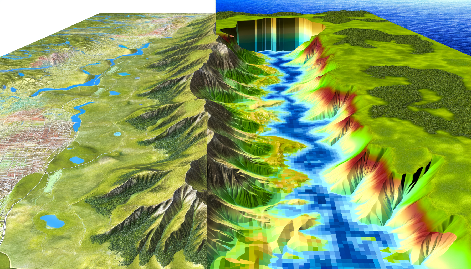
Consider the difference between looking at a contour map of a rugged mountain range and viewing a realistic 3D model of that same range.
The contour map provides the data, but the 3D model provides the *experience* and the intuitive understanding.
You can instantly see how challenging a climb might be, identify potential viewpoints, or spot hidden features based on how the light hits the slopes.
This intuitive grasp of the terrain's character is often lost in the abstract representation of contour lines and spot elevations.
For tasks where elevation and slope are critical, this lack of immediate, intuitive understanding can lead to miscalculations, unexpected challenges, or missed opportunities.
A seemingly short distance on a flat map might involve a grueling vertical ascent.
A planned building site might have unforeseen drainage issues due to subtle slopes not obvious from contours.
Without seeing the relief, you are missing a fundamental piece of the puzzle – the very ground truth upon which everything else sits.
While skilled map readers can extract a wealth of information from traditional topographic maps, the process still requires effort and interpretation.
It's not the natural way we perceive the world, which is always in three dimensions.
Modern digital mapping technology, particularly the ability to render accurate terrain models, offers a powerful way to overcome this limitation and provide a mapping experience that aligns more closely with our natural spatial perception.
Introducing Relief: More Than Just Elevation Data
Relief, in geographical terms, refers to the variation in elevation across an area of the Earth's surface.
It encompasses everything from towering mountains and deep canyons to rolling hills, gentle slopes, and flat plains.
It is the very form and structure of the land.
While raw elevation data – essentially lists or grids of heights above sea level – is the foundation, visualizing relief goes far beyond simply showing these numbers.
It involves processing this data and rendering it in a way that creates a realistic, intuitive, and informative representation of the terrain.
This visualization uses techniques like shading, coloring based on elevation, and creating a three-dimensional perspective that allows you to see the ups and downs, the steepness and gentleness of slopes, and the overall shape of the landscape as if you were viewing it from above or from a particular vantage point.
Why does this matter?
Because relief influences almost every aspect of our physical environment and our interaction with it.
It dictates where water flows, affects climate patterns, determines vegetation distribution, influences building possibilities, and shapes human settlement.
Understanding relief is essential for predicting natural hazards like landslides or floods, for planning efficient routes of travel, and for appreciating the natural beauty of a region.
Visualizing relief provides context that flat maps simply cannot.
It helps you understand the relationship between different features – how a river cuts through a valley, how a road winds its way up a mountain pass, or why a particular area is prone to flooding.
This intuitive understanding is invaluable for decision-making, planning, and exploration in a wide range of fields and activities.
Experience the Depth: Key Applications of Terrain Relief Visualization
The ability to visualize terrain relief in a realistic and interactive way unlocks powerful possibilities across numerous domains.
Moving beyond flat maps isn't just a technological novelty; it's a transformative shift that enhances understanding and capability for diverse users.
Here, we explore some of the key areas where experiencing the relief makes a significant difference.
Navigating the Vertical World: Outdoor Activities
For hikers, trail runners, mountain bikers, mountaineers, and anyone who ventures into the outdoors, understanding the terrain is paramount for safety, enjoyment, and successful planning.
Flat maps can show the trail line, but they don't immediately convey the difficulty of the ascent or descent.
Visualizing relief allows outdoor enthusiasts to:
1. Assess Trail Difficulty: Instantly see the steepness of slopes along a planned route, helping determine if it matches their fitness level and experience.
2. Plan Efficient Routes: Identify ridgelines for easier travel or valleys for water sources.
Avoid unexpectedly difficult terrain or identify potential shortcuts if terrain allows.
3. Understand Line of Sight: Crucial for navigation in challenging conditions or for selecting campsites with good views or protection.
See what lies around the next bend or over the next hill.
4. Anticipate Hazards: Recognize potential areas for rockfall, avalanche paths (in winter conditions, combined with other data), or difficult stream crossings based on the terrain shape.
5. Enhance Enjoyment: Gain a deeper appreciation for the landscape they are moving through.
Identify scenic viewpoints or understand the geological forces that shaped the area.
Instead of laborious interpretation of contour lines, outdoor adventurers can gain an immediate, intuitive sense of the physical challenge and character of their intended path, leading to safer and more rewarding experiences.
This immediate visual understanding is particularly valuable for route planning and decision-making in the field.
Building, Planning, and Infrastructure Development
Engineers, architects, urban planners, land developers, and construction managers rely heavily on accurate terrain information.
Relief visualization is not a luxury for these professionals; it's a necessity for making informed decisions that impact the built environment and public safety.
Key applications include:
1. Site Selection: Quickly evaluate potential building sites based on slope, drainage patterns, and the amount of earthmoving that would be required.
Avoid areas prone to erosion or instability.
2. Drainage Analysis: Understand how water will flow across a property or development area based on the micro-relief.
Plan effective drainage systems to prevent flooding and erosion.
3. Infrastructure Design: Plan the optimal routes for roads, pipelines, power lines, and other infrastructure, minimizing steep grades and construction challenges posed by the terrain.
4. Cut and Fill Estimation: Get a visual sense of the volume of soil that needs to be removed (cut) or added (fill) during construction, helping to estimate costs and environmental impact.
5. Visual Impact Assessment: See how a proposed structure or development will sit within the landscape and its visual impact on surrounding areas.
Crucial for permitting and community acceptance.
For these professionals, relief visualization transforms abstract data into a practical, actionable model of the site.
It facilitates collaboration and communication among project stakeholders who may not all have expertise in interpreting traditional topographic maps.
Seeing the terrain realistically reduces errors and improves the efficiency and safety of development projects.
Education, Research, and Environmental Understanding
From primary school classrooms to advanced scientific research, visualizing terrain relief is a powerful tool for teaching, learning, and exploring the physical world.
Understanding the shape of the land is fundamental to many scientific disciplines.
Applications include:
1. Teaching Geography and Geology: Help students intuitively understand concepts like watersheds, erosion, plate tectonics, and glacial landforms by visualizing how elevation and slope shape the Earth's surface.
Make abstract concepts tangible and engaging.
2. Environmental Studies: Analyze how terrain influences ecosystems, vegetation patterns, wildlife habitats, and the movement of pollutants.
Study the impact of climate change on features like glaciers or permafrost thaw.
3. Hydrological Research: Map drainage basins, model water flow, and study river systems in detail, which is essential for water management, flood prediction, and ecological studies.
4. Climate Science: Understand how elevation affects local climate conditions, such as temperature variations, precipitation patterns, and wind flow.
5. Historical and Archaeological Studies: Relate historical events, settlement patterns, and archaeological sites to the underlying terrain, understanding how geography influenced human activity.
For educators and researchers, relief visualization makes complex spatial relationships clear and allows for deeper analysis and understanding of environmental processes.
It transforms passive map viewing into active exploration and discovery, fostering curiosity and insight into the natural world.
Immersive Environments: Gaming and Simulation
Beyond practical applications, realistic terrain relief is vital for creating believable and engaging digital environments in gaming and simulation.
Whether it's a flight simulator, a military training exercise, a driving game, or an open-world adventure, the fidelity of the terrain significantly impacts the realism and player experience.
1. Enhanced Realism: Accurate representation of mountains, valleys, and other landforms makes digital worlds feel more authentic and grounded in reality.
This is crucial for simulation purposes where trainees need to recognize real-world terrain.
2. Improved Gameplay: Terrain influences strategy and tactics in many games, from taking the high ground in a combat scenario to planning routes in a racing game.
Realistic relief provides meaningful challenges and opportunities.
3. Greater Immersion: Seeing the landscape unfold in three dimensions creates a sense of presence and depth that flat maps cannot replicate.
It draws the user deeper into the simulated environment.
While the primary focus of TESTPLAY is often on practical mapping, the underlying technology that renders realistic terrain is closely related to that used in high-fidelity simulation and gaming, demonstrating the versatility and power of robust 3D visualization.
Our commitment to detailed and accurate terrain benefits not just practical users but also those interested in building or experiencing realistic digital worlds.
TESTPLAY's Relief: Bringing True Depth to Your Digital Map Experience
Understanding the profound importance and wide-ranging applications of terrain relief is just the first step.
The next is building the technology and platform that makes this visualization accessible and powerful for everyone.
At TESTPLAY, we have prioritized bringing accurate, interactive, and beautiful relief mapping features to our users.
We aim to move you beyond simply seeing data points to truly experiencing the landscape through your screen.
The Foundation: Advanced Data and Technology
Creating realistic terrain visualization starts with high-quality data.
TESTPLAY utilizes sophisticated Digital Elevation Models (DEMs) sourced from various reliable providers, including satellite data, aerial surveys, and other topographic sources.
These DEMs provide a grid of elevation points across the landscape.
The resolution and accuracy of these underlying data sets are critical for rendering terrain with fine detail and fidelity.
However, raw data is not enough.
Bringing it to life requires advanced rendering technology.
TESTPLAY employs modern graphics techniques to transform this elevation data into a smooth, shaded, and visually compelling 3D surface.
This includes techniques like hillshading, which simulates the effect of sunlight on the terrain to highlight slopes and shapes, and potentially incorporating color ramps or textures that correspond to elevation ranges or land cover.
Our infrastructure is designed to handle and process vast amounts of terrain data efficiently, ensuring that the maps load quickly and feel responsive even when dealing with large or complex areas.
Furthermore, this terrain data is seamlessly integrated with other mapping layers.
You can view roads, buildings, points of interest, and other geographical features accurately positioned on the rendered relief.
This layering is crucial for providing context and making the relief useful for real-world applications, allowing you to see how human infrastructure interacts with the natural landscape.
Seamless Integration and Intuitive Controls
Powerful technology is only effective if it is easy to use.
TESTPLAY's relief features are integrated into the core mapping experience, not hidden away in complex menus.
Switching to a view that incorporates relief is straightforward, often just a toggle or a change in camera perspective.
Once in a relief view, navigation is intuitive; you can pan, zoom, rotate, and tilt the map to view the terrain from any angle or distance.
We offer controls that allow you to explore the terrain in a way that feels natural.
You can fly over mountains, peer into valleys, and examine slopes up close.
Some features may even allow for exaggeration of the vertical dimension to make subtle elevation changes more apparent in relatively flat areas, a useful tool for analysis and planning.
The goal is to make interacting with the 3D landscape as easy as navigating a traditional 2D map.
Visual Fidelity: Seeing is Believing
The visual quality of the rendered relief is paramount.
TESTPLAY is committed to providing a level of fidelity that makes the terrain instantly recognizable and understandable.
Realistic shading, smooth transitions between different elevations, and accurate rendering of features contribute to a compelling visual experience.
When you see the landscape rendered in TESTPLAY, you should feel like you are getting a true representation of the physical world.
This high visual fidelity is not just for aesthetics; it directly contributes to the clarity and utility of the map for interpretation and decision-making.
By combining high-resolution data, advanced rendering techniques, and user-friendly controls, TESTPLAY transforms the abstract concept of elevation data into a tangible, explorable, three-dimensional world.
We move beyond merely showing you contour lines to letting you experience the shape and form of the Earth's surface in vivid detail.
This is what we mean by "Experience the Relief."
The Tangible Benefits of Seeing Terrain in 3D
Implementing robust terrain relief visualization isn't just about creating pretty maps; it delivers significant, tangible benefits to users across all the applications discussed earlier.
The ability to see and interact with the third dimension fundamentally changes how you perceive and utilize spatial information.
Here are some key advantages:
1. Improved Situational Awareness: You gain an instant, intuitive understanding of the landscape.
You can quickly assess the difficulty of terrain, identify potential obstacles or vantage points, and understand how different geographical features relate to each other in three dimensions.
This rapid comprehension is vital in dynamic situations.
2. Enhanced Decision Making: With a clearer understanding of the terrain, you can make more informed decisions.
Whether it's choosing a safer hiking route, selecting the optimal location for infrastructure, or determining the best strategy in a simulation, seeing the relief provides critical context that leads to better outcomes.
3. Greater Confidence in Planning and Navigation: Planning becomes more reliable when you can accurately anticipate the challenges or advantages presented by the terrain.
When navigating, having a visual reference that matches the real-world landscape builds confidence and reduces the risk of getting lost or encountering unexpected difficulties.
4. Richer Understanding of the Landscape: Relief visualization makes geography come alive.
You can appreciate the scale and form of landforms in a way that is impossible with flat maps.
This deeper understanding is valuable for education, research, or simply satisfying your curiosity about the world around you.
5. More Engaging and Intuitive Experience: Interacting with a 3D, realistic terrain model is simply more engaging and easier for many people than interpreting abstract 2D representations.
It aligns better with our natural spatial reasoning abilities and makes map exploration a more enjoyable process.
By providing these benefits, TESTPLAY's relief features empower users to engage with maps on a completely new level.
They transform the map from a static representation into a dynamic, explorable model of the real world, providing insights and capabilities that extend far beyond the limits of flat maps.
Looking Ahead: The Evolution of Relief Mapping with TESTPLAY
The current capabilities for visualizing terrain relief in TESTPLAY represent a significant leap beyond traditional mapping.
However, the field of spatial data and visualization is constantly evolving, and we are committed to staying at the forefront of these advancements.
The future of relief mapping holds even greater potential.
We are continually exploring opportunities to incorporate higher resolution elevation data as it becomes available, providing ever-greater detail and accuracy in our terrain models.
Improvements in rendering technology will allow for even more realistic and immersive representations, potentially including dynamic elements like simulated water flow, environmental conditions tied to elevation, or integration with real-time data sources.
We also look for ways to enhance the analytical capabilities tied to the terrain, allowing users to perform more complex analyses directly within the 3D environment.
Integration with other data types will also deepen the utility of relief maps.
Imagine seeing underground geological layers or visualizing building interiors placed accurately within the 3D terrain context.
As technology progresses, our ability to layer different types of spatial information onto a realistic 3D terrain model will continue to grow, providing richer and more comprehensive digital twins of the physical world.
At TESTPLAY, our dedication to innovation means that our relief mapping features will continue to evolve.
We are excited to explore these future possibilities and further enhance your ability to experience, understand, and interact with the Earth's surface in unprecedented detail and realism.
Our goal is to ensure that TESTPLAY remains the leading platform for users who need to see the world not just on a map, but *as* it truly exists in three dimensions.
Conclusion: Step Beyond the Flat and Explore with TESTPLAY
Flat maps have been the standard for centuries, providing a foundational understanding of geography.
However, in a world that is inherently three-dimensional, relying solely on two-dimensional representations of terrain can be limiting, hindering our ability to fully understand, plan for, and navigate the physical environment.
Recognizing the shape, slope, and configuration of the land – its relief – is crucial for countless activities, from enjoying the great outdoors safely to planning critical infrastructure or educating future generations about the planet.
TESTPLAY is leading the way in moving beyond these limitations by offering powerful, intuitive, and visually stunning terrain relief visualization features.
By leveraging high-quality data and advanced rendering technology, we transform abstract elevation figures into realistic, explorable 3D landscapes.
This allows you to experience the world in depth, gaining immediate, intuitive insights that traditional maps simply cannot provide.
Whether you are assessing trail difficulty, planning a construction site, studying watershed dynamics, or simply exploring a new region from the comfort of your screen, seeing the terrain in 3D fundamentally changes your interaction with the map.
The benefits of this approach are clear: improved situational awareness, enhanced decision-making, greater confidence in planning, a richer understanding of the landscape, and a more engaging mapping experience.
TESTPLAY's commitment to integrating this essential third dimension seamlessly into our platform ensures that these powerful capabilities are accessible and easy to use for everyone.
We invite you to explore the world with TESTPLAY and experience the profound difference that seeing true terrain relief can make.
Ready to step off the flat page and into a world of depth?
Visit TESTPLAY today and discover the power of experiencing the relief for yourself.
Unlock a new dimension in your mapping and planning, and see the world as you've never seen it on a map before.