


The world is a vast and fascinating place, full of incredible natural wonders just waiting to be explored and understood. Among the most awe-inspiring of these features are mountains, those colossal sentinels of stone and earth that scrape the sky. Teaching children about mountains isn't just a lesson in geography; it is an invitation to marvel at the planet's raw power and beauty.
However, explaining complex geographical concepts like elevation, topography, and mountain ranges to young minds can sometimes feel like climbing a steep slope ourselves. Flat maps, while essential, often fail to convey the dramatic verticality and intricate shapes of mountainous terrain. Children may struggle to visualize what a contour line truly represents on a real landscape.
This is where hands-on, tactile learning tools become invaluable. They bridge the gap between abstract representation and concrete understanding, making learning not only easier but also much more engaging and memorable. This post explores how using a dynamic and interactive tool, specifically a TESTPLAY 3D Map, can transform the way you teach kids about mountains, turning potential frustration into exciting discovery. It offers a powerful solution to the challenge of bringing mountain geography to life for young learners.
Why Teach Kids About Mountains? Understanding Earth's Giants
Mountains are fundamental features of our planet's surface, shaping climates, influencing weather patterns, and acting as crucial water sources. They are home to unique ecosystems and biodiversity found nowhere else. Understanding mountains helps children grasp concepts related to geology, ecology, and even human history and culture, as mountains have often played significant roles in human migration, conflict, and settlement.
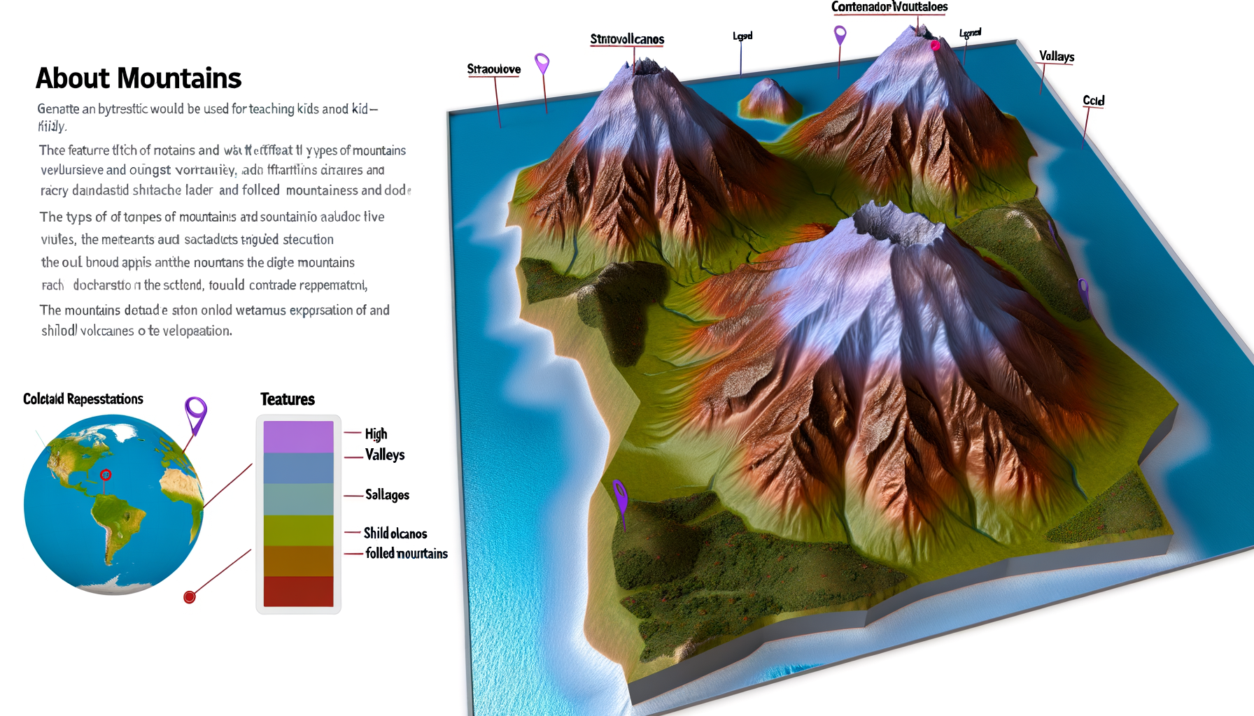
Teaching kids about mountains introduces them to diverse landscapes like peaks, valleys, ridges, and plateaus. It provides a context for discussing different types of mountains, such as folded, fault-block, volcanic, and dome mountains, and the powerful geological forces that create them over millions of years. This knowledge builds a foundational understanding of Earth science and the dynamic nature of our planet. Moreover, learning about mountains can inspire a sense of wonder and a desire to explore and protect the natural world, fostering environmental stewardship from a young age.
Challenges of Teaching Geography Using Traditional Methods
Traditional geography lessons often rely heavily on two-dimensional maps and diagrams found in textbooks or atlases. While these resources are valuable and necessary, they present significant challenges when trying to teach three-dimensional concepts like elevation and relief. For a child, a contour line on a flat map can look like nothing more than an abstract squiggle, disconnected from the idea of slope or height. Visualizing a mountain range based solely on lines and colors on a flat surface requires a level of spatial reasoning that many young children have not yet fully developed.
Explaining concepts like 'above sea level' or the difference in elevation between a valley floor and a mountain peak using only verbal descriptions or flat images can be difficult. Children might struggle to grasp the *feeling* of steepness or the scale of a mountain range when it is flattened onto a page. This abstract nature of 2D geography can lead to disengagement, confusion, and a lack of deep understanding, making the learning process less effective and enjoyable for both the child and the educator. The static nature of these tools limits the ability for interactive exploration and discovery.
The Power of Hands-On Learning: Bringing Geography to Life
Hands-on learning is a pedagogical approach that emphasizes direct experience and interaction with the subject matter. Instead of passively receiving information, children actively engage with materials, manipulate objects, and explore concepts through doing. This approach is particularly effective for young learners because it aligns with their natural curiosity and their need to interact with the world around them physically. When it comes to geography, hands-on methods can make abstract concepts tangible and understandable.
Tactile exploration, building models, and interacting with physical representations of geographical features help children develop spatial reasoning skills. They can feel the difference between a mountain and a plain, understand scale by comparing the size of a model to a real feature, and visualize relationships between different landforms. This direct engagement strengthens memory retention and makes learning more meaningful and enjoyable. It transforms geography from a dry subject of names and places into an exciting exploration of Earth's diverse landscapes.
Introducing the TESTPLAY 3D Map: A Revolution in Learning
The TESTPLAY 3D Map is designed specifically to leverage the power of hands-on learning for geographical education. Unlike traditional flat maps, this tool provides a raised, tactile representation of Earth's surface, bringing mountains, valleys, and plateaus literally into a child's hands. The elevated terrain allows children to feel the slopes, trace the ridges, and understand elevation in a way that is simply impossible with a 2D map. Its design is often robust and durable, suitable for active play and exploration by children.
Using a TESTPLAY 3D Map makes the abstract concept of topography concrete and intuitive. Children can see and feel how contour lines on a corresponding 2D map (if available, or explained conceptually) translate to physical height and slope on the 3D model. This tool facilitates a deeper understanding of spatial relationships and the lay of the land, making geography lessons more dynamic and engaging. It transforms learning from a passive activity into an active adventure.
How to Use Your TESTPLAY 3D Map to Explore Mountains
Integrating a TESTPLAY 3D Map into your geography lessons opens up a world of possibilities for engaging, interactive learning about mountains. This tool isn't just a display piece; it is a launching pad for exploration, questions, and discovery. By following a few simple steps and incorporating creative activities, you can maximize the educational impact of the map and help your child develop a profound understanding of mountainous environments. The tactile nature of the map encourages children to interact with it directly, making learning a physical as well as mental exercise.
Here are some structured ways to utilize your TESTPLAY 3D Map effectively when teaching about mountains, moving from initial exploration to understanding specific concepts and engaging in fun activities. Remember that the key is to encourage curiosity and allow children to lead some of the exploration themselves, fostering a sense of ownership over their learning journey. Make it a collaborative adventure rather than a rigid lesson.
Getting Started with Mountain Exploration
The first step with a new TESTPLAY 3D Map, or even a familiar one when focusing on mountains, is simply to explore it freely. Place the map in an accessible area and let your child touch it, trace the lines of the mountains, and feel the different heights. Ask open-ended questions like, "What do you notice about this part of the map?" or "How does this area feel different from that area?" Encourage them to point out what looks like a mountain or a valley.
Initial exploration should be about familiarization and sparking curiosity. Don't worry too much about specific terms or facts right away. The goal is to help the child become comfortable with the tactile surface and begin to associate the raised areas with real-world elevation. You can trace imaginary paths over the mountains, pretending to be hikers or mountaineers, which adds an element of imaginative play to the initial engagement. This playful approach helps to build a positive association with learning about geography.
Key Mountain Concepts to Teach Using the Map
Once the child is comfortable exploring the map, you can begin to introduce specific geographical concepts related to mountains. The TESTPLAY 3D Map provides a perfect visual and tactile aid for explaining these ideas in a concrete way. Each concept can be demonstrated directly on the map, allowing the child to see and feel the principle being discussed. This method makes abstract geographical terms much easier to grasp and remember.
You can start with the basics and gradually introduce more complex ideas as your child's understanding grows. Using consistent terminology and pointing directly to the relevant features on the map will reinforce their learning. The ability to physically interact with the terrain is the map's greatest asset in conveying these concepts effectively to young minds.
Elevation and Height
Elevation is simply the height of land above a reference point, usually sea level. On a flat map, this is shown with numbers and contour lines, which can be confusing. On a TESTPLAY 3D Map, elevation is immediately visible and tactile. You can run your hand up the side of a mountain on the map to feel how the elevation increases as you move towards the peak. Compare a low-lying area to the top of a mountain.
Use simple analogies to explain elevation, such as climbing stairs or stacking blocks. Point out that the highest points on the map represent mountain peaks. You can use a small toy figure to demonstrate climbing from a valley floor to a summit on the map, making the concept of gaining elevation very clear and tangible for the child. Discussing how the air gets colder higher up can also link elevation to real-world effects.
Topography and Landforms
Topography refers to the shape and features of the land surface, including its relief – the differences in elevation. Mountains create dramatic topography with specific landforms like peaks, valleys, ridges, and slopes. The TESTPLAY 3D Map clearly displays these features. Point to a sharp peak and explain that it is the summit. Trace your finger along a raised line and explain it is a ridge, like the spine of a mountain.
Show the child the low areas between mountains and explain that these are valleys. Demonstrate how water (imaginary, of course) might flow down the slopes and collect in the valleys. Feeling the different angles of the slopes on the map helps children understand concepts like steepness versus gentleness. This section provides a visual vocabulary for mountain landscapes.
Mountain Ranges and Systems
Mountains rarely stand alone; they are usually part of a chain or group called a mountain range or system. On the TESTPLAY 3D Map, these ranges are clearly visible as interconnected lines of elevated terrain stretching across areas of the map. Trace the length of a major mountain range on the map with your finger. Name famous mountain ranges if they are featured on the map, like the Rockies, the Andes, or the Himalayas.
Explain that these ranges are often formed by the same geological forces acting over vast distances and long periods. Use the map to show how one mountain flows into the next, forming a continuous chain. Discuss how mountain ranges can act as barriers to travel, weather, and even cultural exchange, illustrating their significance beyond just being tall landforms. Understanding ranges helps kids see the bigger geographical picture.
Scale and Perspective
Maps are scaled-down representations of the real world. Teaching scale helps children understand that the relatively small mountains on the map represent enormous landforms in reality. The 3D nature of the TESTPLAY map helps with this by making the height differences apparent, even within the map's scaled representation. You can discuss how much taller the real mountains are compared to their depiction on the map.
Talk about how the perspective changes depending on whether you are looking at the map from above (like a satellite) or viewing it from the side (like standing on the ground). Use the raised relief to explain that while the map shows general shapes and heights, the real mountains are much more rugged and vast. This helps develop a sense of scale and proportional thinking.
Engaging Activities with the Map
To make learning truly fun and solidify understanding, incorporate interactive activities using the TESTPLAY 3D Map. These activities turn passive observation into active engagement, encouraging critical thinking, problem-solving, and creativity. They provide practical ways for children to apply the concepts they are learning about mountains. These ideas can be adapted for different age groups and learning styles, ensuring that the map remains a dynamic educational tool.
Activities can range from simple games to more involved projects, all centered around the physical map. The goal is to use the tactile nature of the map to enhance understanding and make the learning process memorable and enjoyable. Here are a few ideas to get you started, designed to make mountain geography lessons interactive and exciting.
Mountain Scavenger Hunts
Create a list of features for your child to find on the map. This could include finding the tallest peak (if marked or visually apparent), a specific mountain range, a prominent valley, or an area that looks particularly steep. You can provide clues based on location or appearance. This turns learning into a game and encourages careful observation of the map's details.
For older children, you could include finding features based on coordinates if the map has a grid, or asking them to trace a hypothetical river that would flow from the mountains into a lower area. A simple list could be:
1. Find the highest mountain peak on the map.
2. Locate a long mountain range and trace it with your finger.
3. Find a deep valley nestled between mountains.
4. Can you find an area that looks like a plateau (flat area at high elevation)?
5. Point to the area you think would be hardest to climb based on the steepness.
This type of activity reinforces vocabulary and spatial recognition while being inherently fun. It encourages children to actively search and identify features based on their visual and tactile characteristics.
Building Model Mountains on the Map
While you can't build *on* every TESTPLAY 3D Map (check the material), you can use modeling clay or playdough *next to* the map to replicate sections of the terrain or build your own mini-mountains. Have your child try to sculpt a small mountain or a valley using the map as a reference for shape and slope. This activity helps solidify the understanding of how different landforms are shaped.
You can also use small objects, like toy trees or houses, to place on different parts of the map to discuss what kinds of things are found at different elevations. For instance, discussing that trees typically stop growing above a certain height (the treeline) can be visually demonstrated by placing toy trees only below a certain elevation on the map. This connects the geography to ecology and environment.
Storytelling and Imagination
Use the TESTPLAY 3D Map as a backdrop for imaginative stories and adventures. Pretend the map is a real place and create characters who live in or explore the mountains. Where do they live? Do they cross the mountains? What challenges do the mountains present? This integrates geography with language arts and creative thinking.
Allowing children to create narratives around the map makes the geography feel relevant and exciting. They might imagine scaling the highest peak, discovering a hidden valley, or navigating a treacherous pass. This type of play reinforces their mental map of the terrain and makes the features more memorable by associating them with exciting events. It's a powerful way to combine learning with creative expression.
Connecting to Real-World Mountains
Research real mountains or ranges that are represented on the TESTPLAY 3D Map. Look up photos, videos, or facts about them online or in books. Compare the real images to the map's representation. Discuss the actual height of the mountains and compare them to other famous peaks around the world. This connects the abstract model to the real, tangible world.
You can also explore maps of your local area if it has mountainous regions and compare them to the TESTPLAY map's features. Discuss how people live in or near mountains, the challenges they face, and the ways they interact with the mountain environment. This global and local connection reinforces the relevance of geography in everyday life and expands their understanding beyond the map itself.
Benefits Beyond Geography: Developing Essential Skills
Using a TESTPLAY 3D Map to learn about mountains offers numerous benefits that extend far beyond simply understanding geographical concepts. The tactile and visual nature of the map helps children develop crucial cognitive and physical skills. Engaging with the map encourages fine motor skills as children trace routes and point to specific features. It also significantly boosts spatial reasoning, which is the ability to understand and manipulate objects in space, a skill vital for subjects like math, science, and engineering.
Furthermore, using the map encourages critical thinking and problem-solving. Children learn to interpret visual information, make comparisons between different areas on the map, and understand relationships between landforms. Activities like scavenger hunts or planning imaginary journeys require logical thinking and planning. The map also fosters curiosity and a desire to learn more about the world, nurturing a lifelong love for discovery and exploration. Vocabulary related to geography, geology, and ecology is naturally introduced and reinforced through discussion and activities centered around the map.
Making Learning Fun and Memorable
Ultimately, the greatest advantage of using a TESTPLAY 3D Map for teaching kids about mountains is its ability to make the learning process genuinely fun and memorable. Children learn best when they are engaged, interested, and having a good time. The tactile interaction, the visual clarity of the 3D terrain, and the potential for imaginative play transform a potentially dry geography lesson into an exciting exploration. This active engagement leads to deeper understanding and much better retention of information compared to passive learning methods.
When children enjoy what they are learning, they are more likely to ask questions, explore further on their own, and develop a lasting interest in the subject. The positive experiences created by interacting with the map help to build a strong foundation for future learning in geography and related sciences. It's not just about teaching facts; it's about igniting a passion for understanding the amazing planet we live on.
Conclusion: Elevating Geography Education
Teaching children about the majestic world of mountains doesn't have to be a challenge confined to flat pages and abstract concepts. By incorporating a hands-on, tactile tool like the TESTPLAY 3D Map, you can unlock a more engaging, intuitive, and effective way to explore Earth's towering landscapes. This innovative tool makes complex ideas like elevation, topography, and mountain ranges understandable and tangible for young learners. It transforms geography lessons into exciting adventures.
Beyond teaching specific geographical facts, using a 3D map fosters crucial skills such as spatial reasoning, critical thinking, and fine motor development. It nurtures curiosity, encourages imaginative play, and helps connect classroom learning to the real world. For parents and educators seeking to make geography come alive, the TESTPLAY 3D Map offers a powerful solution. Embrace the power of hands-on learning and watch as your children gain a new perspective and appreciation for the incredible mountains that shape our world. It's an investment in their understanding and wonder about the planet.