


Embarking on an outdoor adventure is an exhilarating prospect, whether you are planning a challenging backpacking trip, a scenic day hike, or a multi-day camping excursion. Proper planning is the cornerstone of a successful and safe journey into the wilderness. While digital mapping tools and traditional flat maps offer invaluable information, there is a powerful, often overlooked tool that provides a uniquely intuitive understanding of the landscape: the raised relief map.
Unlike their two-dimensional counterparts, raised relief maps are physical models of the Earth's surface, presenting elevations and topography in a tangible, three-dimensional format. This distinct representation offers a wealth of information that can profoundly impact how you plan your route, assess difficulty, identify potential hazards, and ultimately, experience your adventure. For anyone serious about exploring mountainous or varied terrain, mastering the use of raised relief maps is not just beneficial; it can be transformative, offering insights simply not available through other methods alone.
This comprehensive guide will delve into the world of raised relief maps and demonstrate why they deserve a prominent place in your trip planning toolkit. We will explore what makes them unique, how to effectively read and interpret their three-dimensional data, and provide practical strategies for using them to select routes, estimate effort, and enhance safety. By the end, you will understand the unparalleled value of these tactile tools and be equipped to integrate them into your planning process for more informed and rewarding outdoor experiences.
What are Raised Relief Maps?
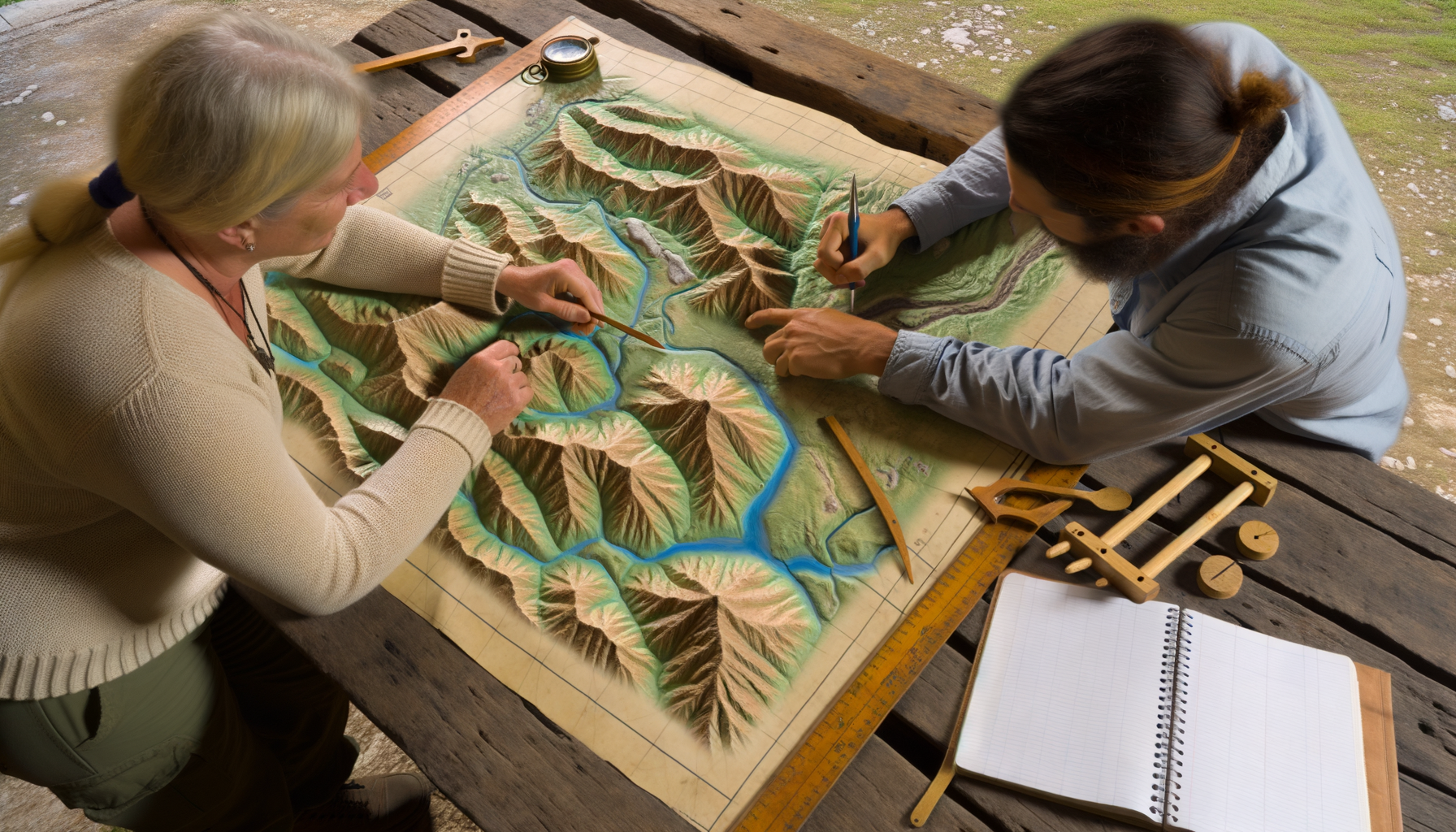
At their core, raised relief maps are physical representations of the Earth's topography. They are created by molding a substrate material, often plastic or paper, to correspond with the elevation data of a specific geographic area. This process results in a map where mountains literally rise from the surface, valleys dip down, and plateaus sit flat, mimicking the actual form of the land.
These maps combine the geographical accuracy of traditional flat maps – displaying features like trails, roads, bodies of water, and points of interest – with the added dimension of physical height. The vertical scale is often exaggerated relative to the horizontal scale to make the elevation changes more noticeable and easier to interpret, especially in areas with subtle topography. This exaggeration is a deliberate design choice that enhances the map's primary function: providing an immediate, intuitive sense of the terrain's shape and steepness.
A Tangible Difference
The most significant difference between raised relief maps and other map types is their tangibility. You can touch the mountains, trace your finger along a ridge, and feel the depth of a canyon. This physical interaction engages different parts of your brain compared to simply looking at lines on a page or screen. It allows for a more visceral understanding of the landscape's complexity and the physical challenges it presents.
While contour lines on a flat map require interpretation to build a mental image of the terrain, a raised relief map presents that image directly. You can instantly see how steep a slope is, how broad a valley is, or how a ridge connects different peaks. This immediate visual and tactile feedback is incredibly powerful for route planning, helping you anticipate climbs and descents in a way that is often harder with abstract contour lines alone.
A Rich History
The concept of creating physical terrain models dates back centuries, long before modern mapping techniques. Early models were often hand-sculpted for military strategy or educational purposes. Raised relief maps in their modern form became more widespread with advancements in printing and molding technologies, particularly in the 20th century.
Government agencies, educational institutions, and specialty map companies have produced raised relief maps for various regions, from national parks and mountain ranges to entire states and continents. While digital maps have become ubiquitous, the enduring appeal and practical utility of raised relief maps for understanding physical terrain have ensured their continued production and use by serious outdoor enthusiasts and professionals alike. Their history underscores their value as a proven method for spatial understanding.
More Than Just Aesthetics
While undeniably visually striking and useful as decorative pieces, the primary purpose of a raised relief map is practical. It serves as a powerful analytical tool for anyone navigating or planning activities in complex terrain. The three-dimensional form facilitates a deeper comprehension of geographical relationships, making it easier to correlate points on the map with real-world features and to understand how elevation changes will impact travel.
For trip planning specifically, this means being able to make more informed decisions about route difficulty, potential visibility from certain points, water flow patterns, and even microclimates based on slope aspect and elevation. It transforms abstract data into a concrete, understandable landscape model. This tangible understanding is a significant asset when preparing for any outdoor excursion.
Why Choose Raised Relief Maps for Planning?
In an age dominated by GPS devices and sophisticated digital mapping applications, it is natural to wonder why a seemingly old-fashioned tool like a raised relief map remains relevant. The answer lies in the unique cognitive and practical advantages they offer, especially when it comes to gaining a true understanding of the terrain you plan to traverse. They provide a perspective that complements, rather than replaces, other mapping tools.
Digital maps are excellent for navigation, real-time location tracking, and accessing vast amounts of data. Flat paper maps are reliable, require no power source, and offer high levels of detail and annotation capabilities. However, neither inherently provides the intuitive, immediate grasp of topography that a raised relief map delivers. This intuitive understanding is where their power for planning truly shines.
Beyond Flatness: The Unique Advantages
The primary advantage is the direct visualization of elevation. You see the hills and mountains as they are, not as abstract lines. This allows for a far more intuitive assessment of slopes and vertical gain. It is easier to identify prominent ridges, significant valleys, and the overall character of the landscape simply by looking at and touching the map.
Another key advantage is the ability to quickly spot major landforms and understand their relationships. You can see how drainages flow, where high points connect via ridges, and where different terrain types transition. This macro-level understanding is crucial for strategic route planning, helping you avoid unnecessarily steep or difficult areas and identify more efficient or scenic paths. Furthermore, the tangible nature of the map facilitates group planning, as everyone can gather around it and clearly see the proposed route in three dimensions, fostering better communication and shared understanding among participants.
Visualizing Terrain Instinctively
The human brain is hardwired to process three-dimensional space. Raised relief maps tap into this natural ability, allowing you to instinctively understand the lay of the land. When planning a hike, you can run your finger along a proposed trail and feel the uphill sections, the level traverses, and the downhill stretches. This physical interaction reinforces your mental map of the route in a way that simply looking at a line on a flat surface cannot replicate.
This intuitive visualization extends to understanding line of sight. While not perfectly accurate due to vertical exaggeration and the map's scale, a relief map can give you a good general idea of what areas might be visible from a particular peak or ridge. This is invaluable for identifying potential viewpoints, understanding communication possibilities, and even assessing exposure to wind or sun based on the terrain's orientation. The ability to gain this kind of immediate spatial insight is a significant benefit.
Enhancing Route Assessment
For hikers, backpackers, and climbers, accurately assessing the difficulty of a route is paramount. While trail descriptions and elevation profiles provide valuable data, a raised relief map offers a ground-level perspective on the terrain's ruggedness. You can see the steepness of ascents, the unevenness of ridges, and the depth of valleys, which helps in estimating the physical effort required and the time it will take to traverse different sections of the trail.
By visualizing the terrain, you can make more informed decisions about adjusting your route based on your group's fitness level, weather conditions, or time constraints. You can identify potential alternative routes or bail-out points by simply scanning the surrounding topography. This enhanced ability to assess and adapt your plans based on a clear understanding of the physical landscape is a key reason to incorporate raised relief maps into your planning process.
Mastering the Art of Reading Raised Relief Maps
While raised relief maps offer an intuitive advantage, they also contain all the standard information found on traditional topographic maps. To fully utilize them for trip planning, you need to understand how to integrate the physical relief information with the symbolic data printed on the surface. This requires understanding standard map conventions in conjunction with the unique properties of the three-dimensional form.
Learning to read a raised relief map effectively involves paying attention to both the physical contours of the mold and the printed features. It's about using the tangible dimension to enhance your understanding of the symbols and lines. With a little practice, you can quickly glean a wealth of information about a region's geography and its suitability for your planned activity.
Understanding Elevation and Slope Visually
This is where the relief map truly shines. Instead of interpreting contour lines to understand slope, you simply look at or touch the physical rise of the map. Steep areas will have a rapid increase in height over a short horizontal distance on the map, while flat areas will be level. Gentle slopes will show a gradual rise.
Pay attention to the relative height differences between features. How much higher is that peak than the valley floor? How steep is the climb to that ridge compared to the traverse along it? The physical form allows for a quick visual comparison of slopes across different parts of the map. Remember the vertical exaggeration; a steep slope on the map will be steep in reality, but it might appear even more dramatic on the map than it feels on the ground due to the scaling difference. This exaggeration is intentional to make the topography more discernible.
Reading Symbols and Legends
Raised relief maps typically feature the same symbols and legends as standard topographic maps for the area they cover. These include symbols for trails (often depicted as dashed or solid lines), roads (varying widths and types), water features (rivers, lakes, streams, springs), vegetation (forests, meadows), buildings, campgrounds, points of interest, and boundaries (parks, wilderness areas).
It is crucial to consult the map's legend to understand what each symbol represents. While the relief shows the *form* of the land, these symbols show the *features* on that land. Combining the two is powerful; for instance, seeing a trail symbol traverse a steep physical slope immediately tells you that section will be a challenging climb. Locating a spring symbol in a protected physical valley suggests a likely water source.
Understanding Scale
Like all maps, raised relief maps have a scale, which indicates the ratio between a distance on the map and the corresponding distance on the ground. This scale is usually printed clearly on the map, often as a fraction (e.g., 1:24,000) or a graphic bar scale. It is essential to understand this scale to accurately estimate distances along your planned route.
Crucially, raised relief maps often employ different horizontal and vertical scales, with the vertical scale being significantly exaggerated. The horizontal scale (e.g., 1:24,000) is used for measuring distances on the ground. The vertical exaggeration makes the terrain stand out. It is important to note this exaggeration when assessing slopes visually; they appear steeper on the map than they truly are. However, this exaggeration enhances the intuitive understanding of relative steepness, making it easier to compare inclines within the mapped area.
Practical Trip Planning Applications
Now that we understand what raised relief maps are and how to read them, let us explore the specific ways they can be applied to make your trip planning more effective and your adventures safer and more enjoyable. Integrating a raised relief map into your planning routine can significantly enhance your preparedness and understanding of the challenges ahead.
From the initial stages of selecting a destination and route to considering potential contingencies, a raised relief map provides a unique perspective that informs crucial decisions. Its tangible nature makes it an excellent tool for planning sessions involving multiple people, allowing everyone to share the same clear visualization of the terrain.
Route Selection Strategies
Choosing the right route is perhaps the most critical aspect of trip planning. A raised relief map allows you to go beyond simply following a line on a map; you can truly visualize the journey. Here are some strategies for using it:
1. Identify Key Landmarks: Use the relief to easily locate prominent peaks, ridges, valleys, and bodies of water that will serve as waypoints or navigational aids.2. Assess Overall Difficulty: Before focusing on specific trails, look at the general ruggedness of the area. Are there long, continuous climbs? Are there numerous steep ridges to cross? This gives you an initial sense of the physical challenge.
3. Trace Potential Paths: Use your finger or a string to trace possible routes, paying attention to how the path interacts with the topography. Follow ridges for potential views and easier navigation, or drop into valleys to access water or shelter.
4. Compare Ascents and Descents: Visually compare the steepness and length of different uphill and downhill sections along various route options. This helps you choose paths that align with your group's capabilities and preferences.
5. Look for Strategic Points: Identify areas that might be good for breaks, campsites, or emergency shelters based on terrain features like level ground, proximity to water (marked by symbols), and protection from wind.
By using these strategies, you can select routes that are not only navigable but also offer the kind of experience you are seeking, whether that is a challenging climb to a summit or a gentler traverse through scenic valleys. The visual assessment provided by the relief map is invaluable for this process.
Estimating Time and Effort
Estimating how long a trip will take is notoriously difficult in variable terrain. While factors like trail conditions, weather, pack weight, and group pace play a significant role, the topography is a primary determinant of travel speed and physical effort. A raised relief map helps you factor the terrain effectively into your time estimates.
Steep uphill sections take significantly longer and require more energy than flat or gently sloping areas. By visually identifying and assessing the length and steepness of climbs and descents on the relief map, you can adjust your time estimates accordingly. A section that looks short horizontally might be a major time sink due to a steep vertical gain. Using the relief map in conjunction with typical hiking speed calculations (e.g., Naismith's Rule, which accounts for elevation gain) provides a more accurate prediction of your travel time. Feeling the terrain on the map helps reinforce these calculations.
Identifying Potential Hazards
Safety is paramount in the outdoors, and understanding potential hazards is a key part of planning. A raised relief map can help you visually identify areas that might pose risks.
Look for extremely steep slopes or cliffs (often depicted with cliff symbols alongside the abrupt change in relief), which could be impassable or dangerous. Identify narrow canyons or deep valleys, which might be prone to flash floods during rain. In winter planning, assess slopes that appear steep and open, as these could be potential avalanche paths, especially on certain aspects. Visualizing drainages also helps identify areas that might become muddy or have significant water crossings after precipitation. Recognizing these potential hazards during the planning phase allows you to either avoid them or plan accordingly with the necessary gear and precautions.
Finding the Best Viewpoints and Campsites
Beyond just getting from point A to point B, most outdoor enthusiasts seek scenic beauty and comfortable, well-situated campsites. A raised relief map is excellent for identifying these desirable locations. High points, prominent ridges, or overlooks depicted on the map are likely candidates for spectacular views.
When looking for campsites, visualize areas with relatively flat terrain (level sections on the map), preferably near a water source (marked by symbols), and potentially sheltered by surrounding terrain features like ridges or forests (if vegetation is indicated). Avoid camping in low-lying areas prone to collecting water or on exposed ridges vulnerable to wind and lightning. The relief map provides the geographical context needed to make these informed decisions about location.
Packing Considerations
The terrain you anticipate traversing directly impacts the gear you should pack. Understanding the elevation changes and ruggedness via a raised relief map helps you make smart packing choices.
If the map shows significant, steep climbs, you might prioritize lighter gear or specialized equipment like trekking poles. If it indicates potentially wet valley bottoms or stream crossings, waterproof footwear or sandals might be necessary. Planning for significant elevation gain also means packing appropriate layers for temperature changes. Assessing the overall difficulty based on the terrain helps you fine-tune your gear list, ensuring you are prepared for the specific conditions you will encounter, thereby improving both comfort and safety.
Acquiring Your Raised Relief Maps
Raised relief maps are specialized products, but they are widely available if you know where to look. Finding a high-quality relief map for your desired area is the first step to incorporating this powerful tool into your planning process. The availability often depends on the popularity of the region and the existence of publishers who create these types of maps.
While not as common as standard paper maps, dedicated map stores, online retailers, and even visitor centers in national parks and popular recreation areas are good sources. Investing in a good relief map for areas you frequent is a worthwhile expenditure for any serious outdoors person.
Where to Find Them
Specialty map retailers, both brick-and-mortar and online, are the most reliable sources for a wide selection of raised relief maps covering various regions. Websites dedicated to outdoor gear and navigation tools often carry them as well. National and state park visitor centers frequently sell raised relief maps specific to their park, which are invaluable resources for planning trips within those boundaries.
Some government agencies or non-profit organizations involved in conservation or recreation may also publish or sell relief maps. Checking the websites of park services or geological surveys for the region you are interested in can sometimes yield results. Look for reputable publishers known for producing high-quality topographic maps, as they are likely candidates for creating relief versions.
Types and Scales Available
Raised relief maps are available in various scales and cover different geographic areas. You might find maps covering large regions, like an entire state or a significant mountain range, which are useful for broad planning and understanding regional geography. More detailed maps focus on smaller areas, such as individual national parks, wilderness areas, or even specific trail systems, often at scales like 1:62,500 or 1:24,000 (though the practical scale for relief is often less detailed than the finest flat maps).
The level of detail, including the precision of the relief molding and the amount of information printed on the surface, can vary between manufacturers and scales. Consider the scope of your typical adventures; a large regional map might suffice for broad route planning, while a detailed park map is essential for navigating specific trails. Choose a map that offers the appropriate balance of coverage and detail for your intended use.
Integrating Raised Relief Maps with Other Tools
While raised relief maps offer unique advantages, they are most powerful when used in conjunction with other planning and navigation tools. No single tool provides all the information you need for every situation in the backcountry. A multi-tool approach ensures you have comprehensive data and redundant navigation methods.
By combining the intuitive terrain understanding of a raised relief map with the detailed information on a flat map, the real-time location data from a GPS or smartphone app, and the descriptive insights from guidebooks, you create a robust planning system. Each tool compensates for the limitations of the others, leading to safer and more informed decision-making both before and during your trip.
Combining the Best of All Worlds
Use your raised relief map to gain an overall understanding of the terrain, identify major features, and visualize route options. Then, turn to a detailed flat topographic map of the same area for precise contour intervals (remembering the relief map's vertical exaggeration), fine details like minor stream crossings or specific trail junctions, and accurate distance measurements using the horizontal scale. Flat maps are also better for precise compass navigation techniques.
Digital tools, such as GPS devices or smartphone apps with downloaded maps, are excellent for real-time navigation, confirming your location, tracking your progress, and accessing additional data like weather forecasts or geo-referenced photos. Guidebooks provide valuable qualitative information about trail conditions, history, points of interest, and logistical details like trailhead access and permit requirements. Using all these resources together provides the most complete picture possible.
The Synergistic Approach
Imagine planning a traverse of a mountain range. You start with the raised relief map to see the overall shape of the range, identify the highest peaks, understand the major ridge systems, and get a feel for the steepness of the approaches. This gives you a strategic overview.
Next, you consult a detailed flat map to pinpoint exact trailheads, determine precise distances between points, note specific contour lines around difficult sections, and mark potential water sources. You might then use a digital app to check recent trail conditions reported by other hikers or verify access road status. Finally, a guidebook provides historical context, ecological information, and perhaps tips on finding the best campsites or viewpoints that you identified using the relief map. This layered approach, utilizing the strengths of each tool, leads to the most thorough and effective trip plan.
Caring for Your Raised Relief Maps
Raised relief maps, especially those made from vacuum-formed plastic, are durable but require proper care to maintain their integrity and usefulness over time. Unlike a paper map that can be folded and stuffed into a pocket (though this is not ideal for paper maps either), relief maps are bulky and the molded plastic can be susceptible to damage if not handled correctly. Protecting your investment ensures it remains a reliable planning tool for many future adventures.
Taking simple precautions when storing and handling your relief map will prevent bending, crushing, or scratching that could obscure details or compromise the accuracy of the relief. Treat it with the respect due to a valuable piece of navigational equipment. Proper care extends its lifespan significantly.
Preservation is Key
The best way to store a raised relief map is flat, or gently rolled with the relief facing outward, in a protective tube or case. Avoid folding them sharply, as this can crack the plastic along the creases. Keep them away from direct sunlight and excessive heat, which can cause the plastic to warp or fade over time. Extreme cold can also make the plastic brittle and more prone to cracking.
When using the map, especially in the field, be mindful of placing heavy or sharp objects on it that could dent or scratch the surface. If it gets dirty, gently wipe it clean with a damp cloth; avoid harsh chemicals that could damage the ink or plastic. While not designed for use *during* active navigation in adverse weather (a waterproof flat map or digital device is better for that), careful handling during planning and brief consultation in the field is possible with due care.
Conclusion
In a world increasingly reliant on digital screens and abstract data representations, the raised relief map stands out as a powerful, tangible tool for understanding the world around us. For anyone who loves exploring the natural world, particularly in varied or mountainous terrain, the intuitive, three-dimensional perspective offered by these maps is an unparalleled asset in the trip planning process.
They transform the abstract concept of elevation into a physical reality you can see and touch, allowing for a deeper, more intuitive assessment of routes, difficulties, and potential hazards. While they do not replace the need for detailed flat maps, guidebooks, or modern digital navigation tools, they provide a foundational understanding of the landscape that complements and enhances the information from other sources. Integrating a raised relief map into your planning workflow equips you with a unique advantage, enabling you to make more informed decisions and approach your adventures with greater confidence.
So, for your next hiking, backpacking, or climbing trip, consider adding a raised relief map of your destination to your planning table. Experience the difference that tangible terrain visualization makes. Unlocking the power of these remarkable maps will not only make your planning more effective; it will deepen your connection to the landscape and pave the way for more enriching and unforgettable outdoor experiences. Elevate your adventure by planning with the power of relief.