


Exploring Topography: How Raised Relief Maps Unveil the Lay of the Land
Have you ever looked at a standard, flat map and struggled to truly visualize the hills, valleys, and mountains it represents? Contour lines provide valuable data, certainly, but they require interpretation and can sometimes feel abstract. Understanding the real shape of the land – its topography – is crucial for countless activities, from planning a hike to studying geology or designing infrastructure.
Flat maps are excellent tools for showing location, distance, and political boundaries, but they inherently compress a three-dimensional world onto a two-dimensional surface. This flattening can make it challenging to grasp the steepness of a slope or the depth of a canyon at a glance. You might see that a mountain is high, but you don't *feel* its presence.
This is where raised relief maps offer a powerful, intuitive solution. By adding a third dimension – physical elevation – these maps transform abstract data into a tangible representation of the terrain. They allow you to literally feel the shape of the land, providing an immediate and visceral understanding of topography that flat maps simply cannot match.
In this comprehensive guide, we will delve deep into the world of raised relief maps. We will explore what makes them unique, how they are created, their immense benefits across various fields, their diverse applications, and how to choose and use one effectively. Prepare to discover how these remarkable maps literally elevate your understanding of the earth's surface.
What Are Raised Relief Maps? A Definition and Distinction
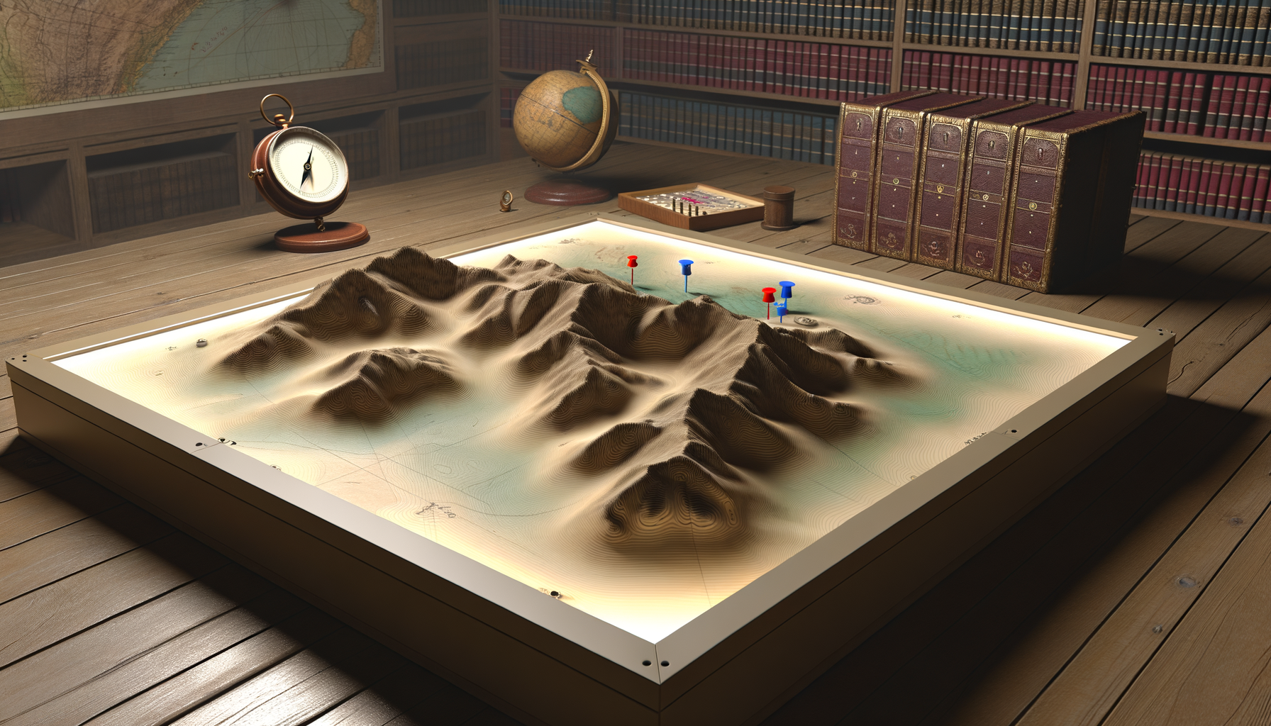
At its core, a raised relief map is a map that physically represents the vertical dimension of the land. Unlike conventional maps printed on paper or displayed on a screen, a raised relief map has a textured surface where areas of higher elevation are physically higher on the map itself, and areas of lower elevation are physically lower. It is a three-dimensional model built upon geographical data.
These maps are typically made by molding a flexible material, often plastic, over a form that depicts the topography. The printed map graphic is then adhered to this molded surface. The result is a map you can not only see but also touch, allowing your fingers to trace the contours of mountains, follow river valleys, and feel the undulation of the landscape.
The fundamental difference between a raised relief map and a standard topographical map lies in the method of conveying elevation. Standard topographical maps use contour lines – lines connecting points of equal elevation – to depict terrain. While accurate and essential, interpreting contour lines requires training and spatial reasoning skills to build a mental image of the landscape. A raised relief map, on the other hand, presents this image directly and physically.
Think of it like the difference between reading a description of a sculpture and touching the sculpture itself. Both provide information, but one offers a direct, tactile experience of form and shape. This tangible quality is the defining characteristic and primary advantage of raised relief maps. They make topography accessible and immediately understandable, even to those with little or no map-reading experience.
Beyond the Flat Surface: Materials and Manufacturing
The creation of raised relief maps is a fascinating process that combines cartography, technology, and manufacturing techniques. Historically, relief models were painstakingly handcrafted from materials like plaster, clay, or wood. These were often large, expensive, and difficult to reproduce accurately. Modern raised relief maps, however, benefit from advancements in data acquisition and production methods.
Today, the process typically begins with highly accurate digital elevation models (DEMs). These digital models are created using various technologies such as satellite imagery, aerial photography (photogrammetry), LiDAR (Light Detection and Ranging), and traditional surveying data. The DEM provides a precise digital representation of the earth's surface, including every bump and dip.
Once the digital model is ready, it needs to be translated into a physical form. A common method involves creating a mold or tooling based on the DEM. This mold serves as the template for the raised surface of the map. Materials like plastic (such as PVC or styrene) are then heated and vacuum-formed over the mold, taking on its three-dimensional shape.
Simultaneously, the two-dimensional map graphic – which includes political boundaries, place names, roads, bodies of water, and often contour lines and color-coding representing elevation zones – is printed separately. This printed graphic must be precisely registered and applied to the molded plastic relief. This requires careful alignment to ensure that features on the printed map correspond exactly to the physical hills, valleys, and plateaus on the molded surface. Specialized printing techniques might even involve printing directly onto the plastic sheet before or after forming. The result is a seamless integration of accurate flat map information with physical, tactile relief.
How Raised Relief Maps Depict Topography Effectively
The primary mechanism by which raised relief maps show topography is through physical height. A mountain range on the map is physically higher than the surrounding lowlands, and a river valley dips down between higher areas. This direct representation of elevation is instantly understandable. You can see the slope of a hillside, the steepness of a cliff face, or the relative height of adjacent peaks just by looking and touching.
However, accurately representing the earth's topography at a usable scale presents a challenge. The vertical scale (elevation difference) is usually much smaller than the horizontal scale (distance across the land). If a map were to maintain a true 1:1 ratio between horizontal and vertical scales, the relief features would be so subtle as to be barely noticeable on a typical map size. For example, Mount Everest would only be a few millimeters high on a map covering the Himalayas.
To make the relief noticeable and impactful, raised relief maps almost always use vertical exaggeration. This means the vertical scale is amplified relative to the horizontal scale. For instance, the vertical scale might be 5 times, 10 times, or even more, greater than the horizontal scale. A map with a horizontal scale of 1:100,000 might have a vertical scale of 1:20,000, resulting in a 5x vertical exaggeration.
Vertical exaggeration makes hills look steeper and mountains look taller than they would in true scale, but it is a necessary cartographic technique to make the relief perceptible and illustrative on the map. While it distorts the true shape of the terrain somewhat, it dramatically improves the viewer's ability to perceive relative elevation changes and understand the general character of the landscape. The amount of exaggeration is carefully chosen by the mapmaker to best represent the topography of the mapped area and is usually noted on the map legend or packaging.
Integrating Relief with Traditional Map Elements
Raised relief maps don't rely solely on the physical shape to convey information; they integrate this three-dimensional aspect with standard two-dimensional map elements. The molded surface serves as a base upon which a wealth of cartographic data is overlaid. This includes essential features like lines of latitude and longitude, political boundaries, cities, towns, roads, railways, rivers, lakes, and points of interest.
Often, raised relief maps also retain contour lines from standard topographical maps. These lines, printed on the molded surface, provide precise elevation data alongside the physical representation. The combination of the physical relief and the contour lines offers both an intuitive visual grasp of the shape and the specific data points for detailed analysis. You can see the hill and also read the elevation of its peak or base.
Furthermore, many raised relief maps use color-coding to indicate elevation zones. Different colors represent different ranges of altitude, providing another visual cue to the changes in terrain. For example, green might indicate lowlands, yellow and orange indicate increasing elevation, and white or grey might represent mountains or glaciers. This color layering works in conjunction with the physical relief and contour lines to create a rich, multi-layered depiction of the landscape.
The power of a raised relief map comes from this synthesis. It combines the intuitive appeal of a physical model with the precision and detail of traditional cartography. The physical dimension enhances the understanding of the printed information, making it easier to connect abstract data like contour lines or color zones to the actual form of the earth. It's a holistic approach to geographic representation.
The Unique Benefits of Exploring with Raised Relief
The advantages of using raised relief maps extend far beyond simply looking at a picture. They offer a unique set of benefits that can enhance learning, planning, and overall geographical understanding. Their tactile and visual nature engages different parts of our brain compared to flat maps, leading to more profound comprehension and retention of spatial information.
Perhaps the most significant benefit is the enhanced understanding of terrain shape and slope. Seeing and touching the physical representation of mountains, valleys, plateaus, and plains provides an immediate, intuitive sense of the landscape's configuration. You can directly perceive the steepness of a slope, the ruggedness of a mountain range, or the flatness of a river delta. This is invaluable for anyone needing to understand the physical challenges or features of an area.
Raised relief maps are also exceptional tools for improving spatial reasoning skills. By interacting with a three-dimensional model, users develop a better ability to visualize landscapes from different perspectives and understand how features relate to one another in three dimensions. This skill is transferable and beneficial in many areas, including navigation, architecture, engineering, and even abstract problem-solving. They help bridge the gap between abstract data and real-world form.
For visual and tactile learners, raised relief maps are particularly effective. Some people learn best by seeing and touching, and these maps cater directly to those learning styles. The ability to physically interact with the map surface reinforces geographical concepts in a way that purely visual or abstract data cannot. This makes them excellent educational aids in classrooms and for self-learners of all ages.
Beyond learning, raised relief maps offer practical advantages for planning activities and projects. When planning a hiking or backpacking trip, seeing the physical elevation gain and loss helps in assessing the difficulty of routes and estimating travel times. For engineers or urban planners, visualizing the terrain in three dimensions aids in site selection, road layout, and understanding drainage patterns. They provide a context that is often harder to piece together solely from contour lines.
Finally, raised relief maps possess significant aesthetic appeal. They are often beautiful objects in themselves, showcasing the grandeur and complexity of the earth's surface. This makes them popular choices for wall displays in homes, offices, museums, and visitor centers, serving as both informative tools and pieces of art. They can spark curiosity and conversation about geography and the natural world.
Summarizing Key Benefits
To reiterate, the core benefits of raised relief maps include:
- Enhanced visualization and intuitive understanding of topography.
- Improved spatial reasoning and 3D perception.
- Effective learning tool, especially for visual and tactile learners.
- Practical aid for planning activities requiring terrain assessment (e.g., hiking, construction).
- Aesthetic value for display and appreciation of geographical form.
These advantages make them a valuable resource for a wide range of users and purposes, offering a perspective on the land that flat maps simply cannot replicate.
Applications and Diverse Uses of Raised Relief Maps
Given their unique capabilities, raised relief maps are utilized in numerous fields and for a variety of purposes. Their ability to make topography tangible makes them indispensable tools in settings where understanding the lay of the land is critical for education, planning, recreation, or presentation. They bridge the gap between abstract geographical data and the physical reality of the earth's surface.
One of the most common and impactful applications is in education. Classrooms from elementary school through university use raised relief maps to teach geography, geology, environmental science, and earth science. Students can see and touch mountain ranges, identify watersheds, understand erosion patterns, and visualize how geological forces shape the landscape. They make abstract concepts concrete and engaging for learners of all ages. Museums and visitor centers also frequently feature large, detailed raised relief maps to orient visitors and explain the geography of a region or park.
Outdoor recreation is another significant area of use. Hikers, backpackers, climbers, skiers, and outdoor enthusiasts benefit immensely from visualizing the terrain they plan to traverse. A raised relief map helps in understanding elevation gain and loss on trails, identifying potential hazards like steep cliffs or rugged areas, and orienting oneself within the landscape. While GPS and digital maps are crucial for real-time navigation, planning with a physical raised relief map provides a powerful overview and understanding of the challenges and features ahead.
In fields like engineering, architecture, and urban planning, raised relief maps are valuable for site analysis and project planning. Engineers can use them to visualize potential routes for roads or pipelines, assess drainage requirements, and plan construction projects in challenging terrain. Architects can understand how a building sits within its landscape, and urban planners can analyze the impact of topography on development, infrastructure, and land use. They provide a crucial three-dimensional context for complex projects.
Geologists and environmental scientists use raised relief maps to study landforms, analyze geological structures, map floodplains, and understand hydrological systems. The physical relief can highlight geological features that might be less apparent on a flat map, such as fault lines expressed as scarps or volcanic cones. They are essential tools for field planning and data interpretation, providing a tangible reference for the features being studied.
Raised relief maps are also used by emergency services and disaster preparedness agencies. Understanding the topography of an area is vital for planning response routes, identifying areas prone to flooding or landslides, and coordinating search and rescue operations. They provide a clear, immediately understandable overview of the operational environment for commanders and field personnel alike. This is particularly important in mountainous or complex urban terrains where elevation plays a critical role in accessibility and safety.
Beyond these practical applications, raised relief maps are popular for display and decorative purposes. Many people appreciate the aesthetic beauty of a well-made raised relief map and hang them in their homes or offices as a piece of art that also holds geographical significance. They serve as conversation starters and reminders of cherished places or geographical features, blending functionality with visual appeal. They connect us physically to the places they represent.
Choosing and Using Your Raised Relief Map
If you're considering acquiring a raised relief map, whether for education, planning, or display, there are several factors to keep in mind to ensure you choose the right one for your needs. Not all raised relief maps are created equal, and understanding the variations can help you make an informed decision. Consider your primary purpose for the map before diving into the options.
The first consideration is the geographical area covered by the map. Do you need a map of your local region, a national park, an entire state or country, or even a continent? The coverage area will dictate the available options and the level of detail. Maps covering smaller areas at larger scales will show much finer terrain detail than maps covering vast regions at smaller scales. Decide what area is most relevant to your interests or activities.
Scale is another crucial factor, just as it is with flat maps. The horizontal scale (e.g., 1:24,000, 1:100,000, 1:1,000,000) determines how much real-world distance is represented by an inch or centimeter on the map. A larger scale map (like 1:24,000) covers a smaller area but shows much greater detail, often including individual buildings, trails, and minor terrain features. A smaller scale map (like 1:1,000,000) covers a large area but shows only major geographical features and cities. Your intended use will heavily influence the appropriate scale. For detailed outdoor planning, a larger scale is usually preferred, while for a general overview or display, a smaller scale covering a larger area might be suitable.
Pay attention to the vertical exaggeration. While some exaggeration is necessary, excessive exaggeration can distort the terrain representation to the point of being misleading, making gentle slopes look like cliffs. The amount of exaggeration should ideally be noted on the map or packaging. Consider whether the level of exaggeration is appropriate for understanding the specific type of terrain shown. Relatively flat areas might require higher exaggeration to show subtle features, while mountainous regions need less exaggeration to avoid looking like an impossible fantasy landscape.
The quality of the printing and the durability of the materials are also important. Look for maps with clear, sharp printing that is well-aligned with the physical relief. The plastic material should be durable enough for its intended use – a map meant for field use might need to be more robust than one intended solely for wall display. Consider how the map is finished; some have a protective coating or are framed for durability and aesthetics. The overall craftsmanship reflects the quality of the underlying data and manufacturing.
Finally, consider the cost. Raised relief maps are typically more expensive than flat maps due to the complex manufacturing process involved in creating the mold and forming the plastic. Prices vary depending on the size, coverage area, detail, and manufacturer. Determine your budget and look for options that offer the best combination of features and quality within that price range. Online retailers and specialty map stores often have a wide selection to compare.
Interpreting and Caring for Your Map
Once you have your raised relief map, understanding how to interpret it fully will maximize its value. While the physical relief is intuitive, remember to use the integrated traditional map elements. Read the title, legend, and scale information carefully. The legend will explain the meaning of different colors, symbols, and line styles used on the map, including the contour interval if contour lines are present. Note the horizontal scale to understand distances and the vertical exaggeration to understand how the physical height relates to true elevation differences.
Use the contour lines (if available) in conjunction with the physical relief to pinpoint exact elevations and determine subtle changes in slope not immediately obvious from the molding alone. Practice identifying features like ridges, saddles, peaks, valleys, and depressions by both sight and touch. Compare the physical shape to how it is represented by contour patterns – this will improve your ability to interpret contour lines on flat maps as well. Use familiar landmarks or features to orient yourself on the map relative to the real world if you are using it in the field.
Caring for a raised relief map involves protecting its physical surface and the printed graphic. Avoid folding or creasing the map, as this can damage the molded plastic. Store it flat or rolled in a tube if necessary. Keep it away from excessive heat or direct sunlight, which can potentially warp or fade the material over time. Clean it gently with a soft, damp cloth if needed, avoiding harsh chemicals that could damage the printing or plastic. With proper care, a raised relief map can be a valuable and long-lasting resource for years to come.
Beyond the Wall: The Future of 3D Mapping
While traditional physical raised relief maps remain powerful tools, the concept of three-dimensional geographical representation is also evolving rapidly in the digital realm. Technologies like interactive 3D models accessible via websites or apps, virtual reality tours of landscapes, and 3D printing of topographical models are becoming increasingly sophisticated and accessible. These digital tools offer dynamic perspectives, the ability to overlay various data layers (like weather patterns or population density), and the potential for highly detailed and customizable models.
However, digital 3D maps, while versatile, do not fully replicate the unique tactile experience of a physical raised relief map. The ability to touch and feel the terrain provides a different kind of engagement and understanding that digital interfaces, for all their strengths, cannot yet fully replicate. There is a certain fundamental understanding gained by physically interacting with the representation of the land that resonates deeply with our spatial perception.
Therefore, it is likely that both physical and digital forms of 3D mapping will continue to coexist and complement each other. Digital tools will excel in dynamic visualization, data integration, and widespread accessibility, while physical raised relief maps will continue to be valued for their intuitive tactile learning experience, aesthetic appeal, and tangible connection to the geography they depict. They serve different but equally valuable purposes in how we explore and understand the earth's complex surface. The future involves a rich ecosystem of geographical visualization tools.
Conclusion: Elevating Your Perspective on Topography
Flat maps are indispensable for navigation and understanding spatial relationships across distance, but they can only provide a limited view of the earth's topography. Raised relief maps offer a compelling alternative by literally adding a dimension to geographical representation, allowing us to see and feel the shape of the land in a way that is both intuitive and profoundly informative. They transform abstract elevation data into a tangible reality.
From enhancing educational experiences and improving spatial reasoning to aiding in detailed planning for outdoor adventures or engineering projects, the benefits of raised relief maps are numerous and significant. They make complex terrain understandable at a glance, engage learners of all ages and styles, and serve as beautiful reminders of the planet's diverse landscapes. They are more than just maps; they are physical models of the world around us.
Whether you are a student, an educator, an outdoor enthusiast, a planning professional, or simply someone fascinated by geography, exploring the world through the lens of a raised relief map offers a unique and rewarding perspective. They provide a deeper connection to the places they depict and foster a richer understanding of the forces that have shaped our planet. If you have never had the chance to interact with one, seek one out.
We encourage you to seek out a raised relief map of a region you know well or a place you dream of visiting. Touch the mountains, trace the rivers, and feel the slopes. Discover for yourself how these remarkable maps truly show the lay of the land and elevate your understanding of topography. They offer a tactile journey into the world of geography that digital tools, while powerful, cannot fully replicate. Start exploring in 3D today!