


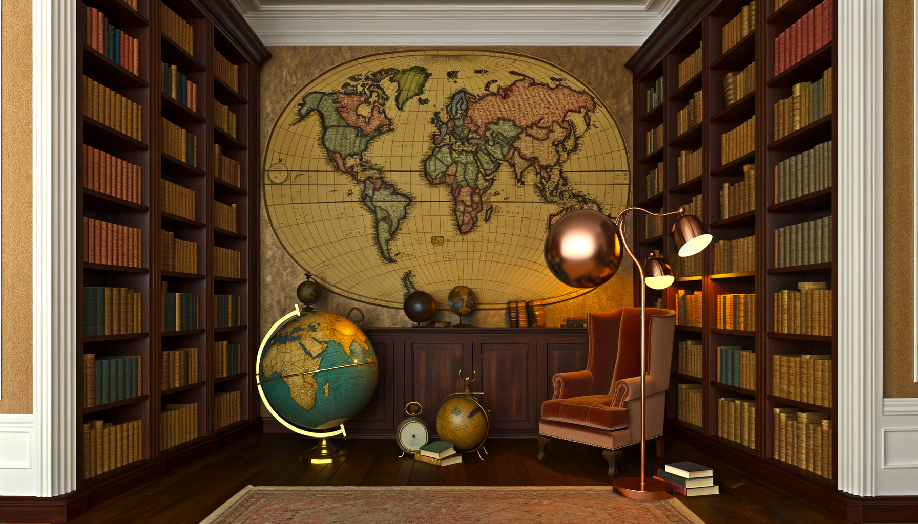
For many, a home library represents more than just a collection of books; it is a sanctuary for learning, reflection, and escape. It is a space where knowledge is curated, ideas are explored, and worlds, both real and imagined, come to life. While books form the essential foundation, the truly inspiring library often incorporates elements that enhance its purpose and aesthetic appeal. Globes and maps are among the most powerful and evocative additions you can make to such a space.
These geographic tools are not merely decorative objects; they are portals to history, guides to potential adventures, and constant reminders of the vast and diverse world we inhabit. Integrating globes and maps thoughtfully into your home library can elevate it from a simple book storage area to a dynamic center of geographic and historical discovery. However, knowing where to start, what to choose, and how to best incorporate them can feel overwhelming.
This comprehensive guide is designed to provide you with the authoritative information you need to confidently select, place, and care for globes and maps within your home library. We will explore their timeless appeal, discuss the various types available, offer practical advice on integration and design, and detail essential preservation techniques. By the end, you will have a clear roadmap for transforming your library into a truly inspiring and geographically rich environment, fostering curiosity and learning for everyone who enters.
The Enduring Appeal and Value of Globes and Maps in Your Home Library
Long before the advent of digital screens and GPS, globes and maps were the primary tools for understanding our planet's geography. They were objects of science, exploration, and art. In a world increasingly reliant on ephemeral digital information, physical globes and maps offer a tangible, enduring connection to the Earth. They possess a unique charm and gravitas that complements the tactile experience of reading a physical book.
Including these items in your library does more than just fill empty space; it injects the room with a sense of history, scale, and possibility. They invite interaction, prompting viewers to spin the globe, trace a historical route on a map, or locate a far-off land mentioned in a book. This inherent interactivity distinguishes them from passive decor, making them active participants in the library's function as a place of learning and engagement.
Beyond Decor: Aesthetic and Intellectual Enrichment
Aesthetically, globes and maps can be stunning additions to any room, offering rich colors, intricate details, and interesting textures. An antique globe with its aged patina and unique cartography tells a story of a different era, while a modern, well-lit globe can bring vibrant contemporary data to life. Framed maps can serve as powerful wall art, drawing the eye and providing a focal point that is both beautiful and informative. Their visual complexity rewards close inspection, revealing layers of detail that online maps often obscure in their quest for simplicity.
Intellectually, globes and maps are unparalleled resources. They provide context for everything from current events to historical narratives and fictional settings. Reading about a journey across continents in a novel takes on a new dimension when you can immediately locate the places on a nearby map or globe. Understanding the geography of a historical conflict becomes clearer when you can see the terrain and proximity of key locations. They bridge the gap between abstract concepts and concrete reality, making learning more intuitive and memorable.
Fostering Curiosity and Learning
Globes and maps are powerful catalysts for curiosity, especially for younger minds, but equally for adults. They invite questions about distances, climates, cultures, and the interconnectedness of the world. A child spinning a globe might ask about the animals in Australia, the tallest mountain range, or how people live in different zones. An adult might ponder the geopolitical significance of a border or trace the path of a famous explorer.
They serve as excellent informal teaching tools. Learning about continents, countries, oceans, and major geographic features becomes an engaging activity rather than a dry lesson. Historical maps, showing past borders and names, offer fascinating insights into geopolitical shifts and the passage of time. By having these tools readily available in a comfortable library setting, you encourage spontaneous learning and discovery at any moment inspiration strikes.
Anchors of Conversation and Connection
A well-placed globe or a striking map instantly becomes a conversation piece. Guests are naturally drawn to them, sparking discussions about travel experiences, ancestral origins, historical events, or simply the beauty of cartography. They offer a shared point of reference and connection, grounding conversations in the physical reality of the world. This makes your library not only a personal retreat but also a welcoming space for shared exploration and dialogue.
Discussing a book set in a specific location becomes more vivid when you can point to the place on a map. Sharing travel aspirations feels more real when you can visualize the journey on a globe. These geographic elements create opportunities for meaningful interaction, enriching the social function of your home library and connecting people through shared interests in the world.
Selecting the Perfect Companions: Choosing Globes and Maps
With the myriad of options available, choosing the right globes and maps for your library requires thoughtful consideration. The best pieces will align with your library's overall style, your personal interests, and the space you have available. Understanding the different types and their characteristics is the first step in building a meaningful collection. Whether you are seeking a classic look, historical accuracy, modern data, or simply an inspiring visual, there is a globe and map out there for you.
It is helpful to approach the selection process by thinking about the primary purpose each piece will serve. Is it primarily for decoration, serious geographical study, historical reference, or sparking the imagination? Knowing this will guide your choices regarding type, size, detail, and condition. Mixing different types can also create a more dynamic and comprehensive collection over time.
Navigating the World of Globes
Globes come in various forms, each offering a distinct perspective on our planet or the cosmos. From traditional terrestrial globes depicting political boundaries to those illustrating physical features or even celestial bodies, the options are diverse. Understanding these types will help you select pieces that best suit your interests and the educational focus of your library. Consider what kind of global view you wish to emphasize in your collection.
Exploring Globe Types
Political Globes: These are perhaps the most common type, clearly showing countries, their borders, capitals, and major cities. They are excellent for understanding contemporary geopolitics and the political divisions of the world. The colors often represent different countries, making it easy to distinguish between them. They are a fundamental tool for keeping up with world affairs and general geography.
Physical Globes: In contrast to political globes, physical globes illustrate the Earth's topography. They show mountain ranges, deserts, plains, and ocean depths, often using raised relief or varying shades of color to depict elevation. These globes are fantastic for understanding the physical forces that shape our planet and the geographical challenges or advantages faced by populations. They offer a tangible representation of the Earth's varied surface.
Antique and Reproduction Globes: Antique globes are valuable historical artifacts, showcasing the geographic understanding of a specific time period. Their maps may be outdated, but their craftsmanship, patina, and historical context make them fascinating collectibles. Reproduction globes replicate the style and appearance of historical globes but are newly manufactured, offering an old-world aesthetic without the fragility and cost of a genuine antique. They bring a sense of history and elegance to the library space.
Celestial Globes: Instead of the Earth, these globes map the stars and constellations as viewed from Earth. They are wonderful additions for anyone interested in astronomy, mythology, or the history of celestial navigation. They offer a different kind of world view, connecting your library to the wider universe. A celestial globe can add a touch of wonder and expand the scope of your collection beyond terrestrial concerns.
Modern and Interactive Globes: Technology has also influenced globe design, leading to illuminated globes, those with internal projectors, or even app-connected smart globes that display information via augmented reality. These offer dynamic ways to explore data, from population density to weather patterns. While perhaps less traditional, they can be exciting tools for engaging with contemporary information about the world. They appeal particularly to tech-savvy individuals or families seeking interactive learning experiences.
Factors in Globe Selection
Size and Scale: Globes come in various diameters, from small desk models (6-8 inches) to large floor-standing versions (20 inches or more). Consider the space available in your library and the level of detail you desire. A larger globe allows for greater cartographic detail but requires more room. A desk globe is convenient for close examination and fits on a table or shelf. Floor globes make a dramatic statement and are excellent focal points.
Base and Stand: The globe's base or stand significantly impacts its stability and aesthetic. Materials range from wood and metal to modern plastics. Styles can be traditional, contemporary, or ornate. Ensure the base is sturdy and complements your library's decor. A well-crafted stand enhances the perceived value and beauty of the globe itself. Some stands include features like compasses or calendars, adding extra historical detail.
Cartographic Detail and Accuracy: Examine the map printing on the globe carefully. Look for clear labels, accurate boundaries (if a political globe, note its date of publication as boundaries change), and legibility. The quality of the cartography is paramount to the globe's educational value. High-quality printing ensures that even small text is readable and colors are vibrant. For physical globes, check the quality of the raised relief.
Condition (for Vintage or Antique): If you are considering a vintage or antique globe, assess its condition. Look for cracks, dents, fading, peeling paper gores (the printed segments that form the sphere), and damage to the stand. While some wear is expected and adds to the character, significant damage can affect stability and appearance. Understand whether any restoration work has been done. The condition will greatly influence the value and longevity of the piece.
Budget: Globes can range significantly in price, from under a hundred dollars for basic models to thousands or tens of thousands for large, antique, or expertly crafted pieces. Set a budget before you begin searching. Determine if you are looking for a functional tool, a decorative accent, or a serious collectible. This will help narrow your options and ensure you find a globe that meets your needs without overspending. Remember that a good quality globe is an investment that can last for generations.
Unfolding the Versatility of Maps
Maps offer a different, often more detailed, perspective than globes. They allow for larger scale representations of specific areas and come in formats suitable for wall display, desktop reference, or focused study. Incorporating maps adds layers of geographic and historical information to your library, offering opportunities for closer examination of regions, cities, or specific historical periods. The variety of map types means you can tailor your collection to highly specific interests.
From expansive wall maps that dominate a space to intricate historical charts or detailed atlases, maps provide incredible visual and informational richness. They can serve as historical documents, beautiful pieces of art, or practical tools for planning and understanding. Consider the stories you want your maps to tell and the information you want them to convey when making your selections.
A World of Maps for Your Walls and Shelves
Wall Maps: Large, often laminated or mounted, wall maps are designed for display. They can be political, physical, or thematic (showing climate, population, etc.). Framed wall maps make excellent decorative statements and provide a constant, easily accessible reference point. They are ideal for covering large wall spaces and bringing a significant visual element into the library. Choose a scale that offers enough detail for your needs.
Atlases: These are bound collections of maps, often including supplementary information, statistics, and indexes. Atlases are comprehensive reference tools, perfect for in-depth geographical study. They come in various sizes and focus on different themes (world atlases, national atlases, historical atlases, street atlases). An atlas is an essential component for a serious geographic collection within a library, offering portability and a wealth of information.
Historical Maps: These maps depict the world or regions as they were at a specific point in the past. They are invaluable for understanding history, showing changing borders, old place names, exploration routes, and historical events. Historical maps can be captivating pieces, offering a visual link to past centuries. They are wonderful for anyone interested in history, genealogy, or the evolution of cartography itself.
Topographic Maps: Showing elevation and landforms through contour lines, topographic maps are essential for understanding terrain. They are used by hikers, geologists, and anyone interested in the physical details of a landscape. While not always aesthetically decorative in the traditional sense, they offer incredibly detailed and practical information about a specific area. A collection of topographic maps of significant regions can be a valuable resource.
City and Regional Maps: Highly detailed maps focusing on smaller areas like cities, states, or regions. They are useful for local history, urban planning study, or simply navigating a familiar or desired destination. Vintage city maps, showing street layouts and landmarks from decades past, can be particularly charming and historically interesting. These maps offer a closer, more intimate geographic focus compared to world maps.
Digital Maps and Apps: While not physical items for the library shelves, it is worth acknowledging the role of digital mapping tools. They offer convenience and real-time information. However, they lack the tactile pleasure, aesthetic beauty, and historical depth of physical maps. Integrating physical maps into your library provides a different, often richer, interaction with geographic information that digital formats cannot replicate.
Key Considerations When Choosing Maps
Purpose: Define why you want a particular map. Is it for decoration, a specific reference need, historical accuracy, or to mark places you have visited? This will dictate the type, style, and detail required. A map for decorative purposes might prioritize color and design, while a reference map needs high accuracy and legibility.
Scale and Detail: Maps are produced at various scales. A large-scale map shows a smaller area with greater detail (e.g., a city map), while a small-scale map shows a larger area with less detail (e.g., a world map). Consider what level of geographic information you need for your intended use. For studying a specific region, a larger scale map or atlas page is necessary.
Format: Maps come rolled, folded, bound in atlases, or pre-mounted/framed. Rolled maps are good for storage but need framing for display. Folded maps are convenient for reference but can suffer wear along creases. Atlases are ideal for comprehensive reference. Consider how you intend to use and display the map when choosing its format.
Condition and Material: The paper quality, printing method, and overall condition are important, especially for older or valuable maps. Look for signs of damage, such as tears, stains, fading, or brittleness. Archival quality paper and printing are desirable for longevity. Laminated maps are durable but may have glare. For antique maps, minor imperfections can add character, but significant damage impacts value and preservation needs.
Accuracy and Date: Pay attention to the date of publication or the period the map represents. For contemporary geography, ensure the map is recent. For historical purposes, confirm the map accurately reflects the era it depicts. Note that even recent maps can have slight inaccuracies or variations depending on the cartographer and source data. The date of a map is a crucial piece of information that tells you about the geopolitical and geographic knowledge of its time.
Style and Aesthetics: Maps come in countless artistic styles, from minimalist modern designs to ornate, illustrative antique charts. Choose maps whose visual style complements the existing decor of your library and aligns with your personal taste. The color palette, font choices, and decorative elements all contribute to the map's aesthetic appeal. A map should be a piece of art as well as a source of information.
Designing Your Geospatial Sanctuary: Integrating Globes and Maps
Once you have selected your globes and maps, the next step is to integrate them seamlessly into your home library's design. Thoughtful placement and arrangement can maximize their visual impact, accessibility, and functional value. Consider the layout of your room, the existing furniture, and the interplay between your geographic items and your book collection. The goal is to create a cohesive and inspiring environment that invites exploration.
Integrating these pieces is not just about finding a spot for them; it is about creating vignettes and focal points that draw attention and encourage interaction. Think about how light falls on them, how they relate to nearby books, and how easily you (or visitors) can interact with them. A well-integrated geographic collection enhances the character and intellectual depth of the entire library space.
Strategic Placement for Impact and Access
Globe Placement: Floor-standing globes naturally occupy corners, near seating areas, or beside bookshelves, acting as significant anchors in the room. Ensure there is enough space around a floor globe to allow it to be easily spun and viewed from different angles. Tabletop globes can be placed on desks, consoles, or larger shelves, providing a closer view and serving as a handy reference during reading or work. Consider placing a globe near a comfortable chair to encourage leisurely study.
Map Placement: Wall maps are best hung at eye level in prominent locations, such as above a desk, sofa, or even a central library table. Ensure the wall is large enough for the map's size and that it does not feel cramped. Atlases and smaller maps can be placed on shelves alongside books, making them easily accessible for reference. Consider flat file cabinets for storing loose, valuable maps that are not currently on display, protecting them while keeping them organized.
Consider the flow of the room and how you move within it. Place items where they can be easily accessed and enjoyed without obstructing pathways or other functional areas. Grouping related items, such as a globe and an atlas of the same region, can create a powerful geographic study station. Think about how different pieces can complement each other geographically and thematically.
Lighting Your Geographic Treasures
Appropriate lighting is essential for highlighting the details and beauty of your globes and maps and also for preserving them. Good lighting makes maps easier to read and globes more visually striking. However, it is crucial to protect your collection from damaging light sources. Avoid placing globes or framed maps in direct sunlight, as UV rays can cause fading and deterioration over time. Use blinds or UV-filtering glass for framed pieces near windows.
Consider accent lighting, such as adjustable spotlights directed at a wall map or a floor globe, to draw attention and make them features. Ambient library lighting should be sufficient for comfortably viewing maps on shelves or in atlases. For illuminated globes, their internal light provides a warm glow, acting as both a light source and a display feature. Carefully planned lighting enhances the aesthetic appeal while serving the practical need for visibility and the critical need for preservation.
Creating Cohesive Displays
Integrate your globes and maps with your book collection by grouping them thematically or geographically. For example, place books on African history or travel alongside a detailed map or globe of the African continent. Use maps as dynamic backdrops on shelves by placing framed maps vertically behind book arrangements. Mix different sizes and types of globes and maps to create visual interest.
Combine a small desk globe with an atlas and a stack of travel guides on a side table. Arrange a series of framed historical city maps along one wall, perhaps reflecting your family's heritage or favorite destinations. The key is to create connections between your books and your geographic items, suggesting narratives and encouraging exploration of related topics. Avoid clutter; give each significant piece space to breathe and be appreciated.
Making Globes and Maps Focal Points
If you have a particularly impressive globe or a striking large-format map, consider making it a focal point of your library. A large floor globe can anchor a seating area, inviting people to gather around it. A stunning framed world map can become the central piece on a prominent wall, around which other elements in the room are arranged. Placing a globe or map in a visually dominant position immediately communicates the library's emphasis on global awareness and exploration.
Highlight unique pieces, such as an antique globe with intricate details or a map with unusual cartography. Use lighting and placement to draw the eye to these special items. Making a globe or map a focal point not only enhances the room's design but also reinforces the idea that the library is a place dedicated to exploring the world in its many dimensions. It sets the tone for the entire space, signaling that this is a place where geography matters.
Preserving Your Worldly Collection: Care and Maintenance
Globes and maps, especially older or antique pieces, require proper care to maintain their condition and longevity. Paper and the materials used in globes are susceptible to environmental damage, improper handling, and pests. Implementing a routine of gentle handling, controlling the environment, and appropriate cleaning will help preserve your collection for years to come, ensuring that these valuable tools and beautiful objects remain in good condition. Proper preservation protects your investment and maintains the integrity of the information they contain.
Unlike digital data, physical maps and globes are subject to physical degradation. Understanding the vulnerabilities of paper, ink, and the materials used in their construction is key to preventing damage. Prevention is always easier and less costly than attempting restoration. By establishing good care habits from the outset, you can significantly extend the life of your geographic treasures.
Gentle Handling is Key
Always handle globes and maps with clean, dry hands. Oils and dirt from your skin can transfer to the surfaces over time, causing discoloration and damage. When handling a globe, support it firmly by its stand or base; avoid putting pressure directly on the sphere itself, especially if it is antique or fragile. The paper gores can be delicate and susceptible to tearing or peeling if handled roughly.
For maps, handle them gently by the edges or corners. Avoid touching the printed surface directly whenever possible. When viewing atlases, turn pages carefully to prevent tearing. Do not fold maps that were meant to be stored rolled or flat, as creasing can cause permanent damage to the paper fibers and ink. If a map is framed, handle the frame securely, and avoid touching the glass or map surface within the frame. Teach children and guests how to handle these items with care.
Environmental Guardianship
Environmental factors are among the biggest threats to paper-based items. Light, humidity, and temperature fluctuations can cause irreversible damage. As mentioned earlier, protect globes and framed maps from direct sunlight and strong artificial light sources, which can cause fading of ink and paper and make materials brittle. Consider UV-filtering film on windows or UV-filtering glass for framed items.
Maintain a stable temperature and humidity level in your library. High humidity can lead to mold and mildew growth, while low humidity can make paper brittle. Significant fluctuations in temperature and humidity cause materials to expand and contract, leading to warping and cracking. An environment comfortable for you is usually comfortable for your collection. Aim for relative humidity between 40 percent and 60 percent and temperatures between 60°F and 75°F (15°C and 24°C). Avoid storing valuable items in basements or attics prone to environmental extremes and pest infestations.
Pests, such as silverfish, bookworms, and rodents, are attracted to paper and glue. Regularly inspect your collection for signs of pest activity. Keeping the library clean and free of food debris helps deter pests. If you discover an infestation, consult with a pest control professional who has experience with library or archival materials to ensure that treatments do not damage your collection. Proper storage methods can also help deter pests.
Cleaning and Conservation Basics
Regular, gentle dusting is important to prevent dirt and grime buildup, which can become abrasive and stain surfaces. Use a soft, clean, dry cloth or a soft-bristle brush to gently dust globes. Avoid using cleaning sprays or liquids directly on the globe surface, as these can damage the paper gores or varnish. For framed maps, you can clean the glass with a standard glass cleaner applied to a cloth (not sprayed directly onto the glass), taking care not to let liquid seep under the frame.
For more significant cleaning needs or if you notice damage such as tears, stains, or peeling, it is best to consult a professional conservator specializing in paper, maps, or globes. Attempting complex repairs or cleaning with inappropriate methods can cause further, irreparable damage. A conservator can assess the condition of your items and recommend the best course of action for cleaning, repair, and stabilization, preserving the piece's integrity and value. Do not use tape to repair tears on maps or globes, as adhesive residue is difficult to remove and can cause staining over time.
Smart Storage Solutions
How you store maps that are not on display is crucial for their preservation. Loose maps are best stored flat in acid-free folders or archival boxes within a flat file cabinet. This prevents creasing, minimizes handling, and protects them from light and dust. If a flat file is not possible, store rolled maps in sturdy, acid-free tubes, but be aware that long-term rolling can cause the paper to retain a curve.
Atlases should be stored upright on sturdy shelves that can support their weight, or horizontally in stacks that are not too high to prevent damage to the bindings. Ensure shelves are deep enough so atlases do not hang over the edge, which can damage the spine. Globes, being primarily display items, are usually kept on their stands. If a globe needs to be stored for an extended period, cover it with a soft, breathable cloth to protect it from dust and light. Avoid storing items in areas with extreme temperatures or humidity fluctuations.
The Continuous Journey of Discovery
Integrating globes and maps into your home library is not just about collecting objects; it is about fostering a continuous journey of discovery. These items serve as constant invitations to learn, explore, and connect with the world and its history. They make geography come alive, turning abstract locations into real places filled with stories. Their presence in the library reinforces its purpose as a place for lifelong learning and intellectual adventure.
Beyond their educational utility, globes and maps evoke a sense of wonder and inspire dreams of travel and exploration. They remind us of the vastness of the planet and the endless possibilities for discovery, both through reading and actual experience. They connect the knowledge gained from books to the physical reality of the Earth, creating a more profound and engaging learning experience.
Education Beyond the Classroom
A home library with globes and maps becomes a powerful educational hub, offering learning opportunities that go beyond formal schooling. Use maps to follow the routes of historical explorers discussed in books, understand the settings of historical fiction, or visualize the geography of current events. For children, globes and maps are tactile tools for learning geography in a fun, interactive way. They can trace coastlines, identify countries, and learn about different climates and cultures.
They serve as invaluable reference points when reading, allowing you to immediately locate unfamiliar places and gain context. This immediate access to geographic information enhances comprehension and makes learning more engaging. Using a map or globe to deepen your understanding of a book's setting adds a rich layer to the reading experience, making the narrative more vivid and memorable. They turn reading from a passive activity into an interactive exploration of the world.
Fueling Wanderlust and Planning Adventures
Few things inspire travel like looking at a world map or spinning a globe. They evoke dreams of faraway places and unfamiliar landscapes. Use your maps and globes to plan future trips, tracing potential routes and exploring destinations in detail before you even leave home. Relive past travels by locating places you have visited and reminiscing about your experiences.
Connecting your travel aspirations and memories to physical geographic tools makes the world feel more accessible and real. It transforms abstract destinations into concrete points on a map, fueling the desire to explore them further. Globes and maps are not just records of the past and present; they are catalysts for future adventures, both real and imagined, encouraging you to explore new horizons literally and figuratively.
Building a Collection with Meaning
Your collection of globes and maps can be deeply personal, reflecting your interests, history, and aspirations. You might collect maps of places you have lived, visited, or hope to visit. Perhaps you focus on historical maps related to a specific period or region of interest. Each piece can hold sentimental value, serving as a tangible reminder of a journey, a place of significance, or a historical connection.
Building this collection is an ongoing process, adding pieces that resonate with you and enhance your library's story. It becomes a legacy, a collection that not only educates and inspires you but can also be shared with future generations, passing down a love for geography, history, and the vast, fascinating world we all share. Each map and globe in your library tells a part of that larger story.
Conclusion
Integrating globes and maps into your home library is a rewarding endeavor that significantly enhances its aesthetic appeal, intellectual depth, and inspirational power. These timeless tools serve as beautiful decor, invaluable educational resources, and compelling conversation starters. They connect your world of books to the real world, bringing geography and history to life in a tangible and engaging way.
By carefully selecting pieces that match your interests and style, strategically placing them for maximum impact and accessibility, and committing to their proper care and preservation, you can create a geospatial sanctuary within your home. This dedicated space for exploring the world through maps and globes enriches your own learning and ignites curiosity in others. It is an investment in knowledge, beauty, and the endless journey of discovery.
Embrace the world in its physical form within the comforting walls of your library. Let globes spin stories of distant lands and maps unfold narratives of history and adventure. Begin building or enhancing your geographic collection today, and watch as your home library transforms into an even more dynamic, inspiring, and globally aware space, a true reflection of a curious and engaged mind.