Tax and Shipping calculated at checkout.
Translation missing: en.products.product.pickup_availability.unavailable
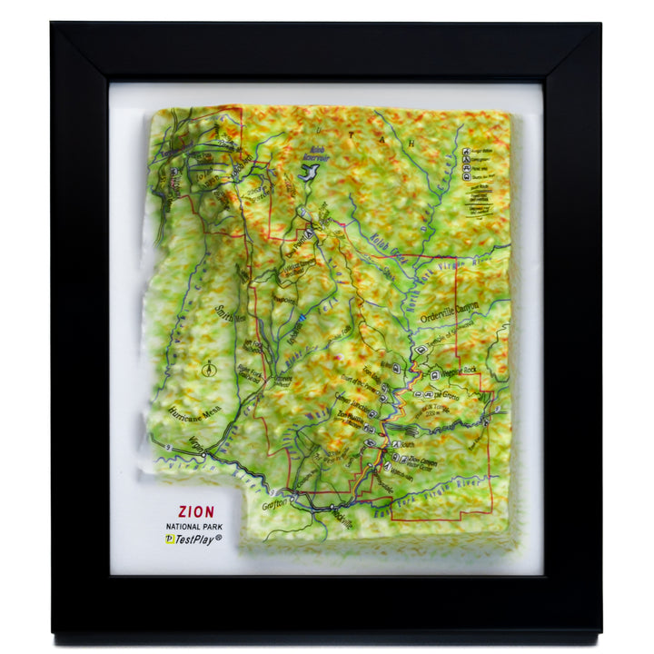
Zion National Park 3D Raised Relief Map – TestPlayNA’s premium 3D topographic maps transform Utah’s iconic red rock wilderness into a stunning, tactile masterpiece. This Zion 3D model map captures the park’s towering sandstone cliffs, deep canyons, and emerald Virgin River in breathtaking raised relief. More than a souvenir — it’s a portable piece of one of America’s most dramatic national parks, perfect for hikers, photographers, and desert adventurers.
Located in southwestern Utah, Zion National Park spans 229 square miles of geological wonder, where colossal sandstone monoliths rise over 2,000 feet from the canyon floor. Carved by the Virgin River over millions of years, Zion Canyon stretches 15 miles long and plunges up to 2,640 feet deep — its crimson and bronze walls glowing at sunrise and sunset. From the sheer face of Angels Landing to the lush hanging gardens of the Narrows, Zion is a paradise of contrast: desert sands, riparian oases, and high-elevation pine forests.
Home to 289 bird species, bighorn sheep, and rare plants found nowhere else, Zion thrives with life. Hikers conquer the heart-pounding chains of Angels Landing (1,488 ft elevation gain), wade through the cool waters of the Virgin River in the Narrows, or explore hidden slot canyons like The Subway. This 3D raised relief map lets you trace every trail, peak, and river bend — from Horse Ranch Mountain (8,726 ft) to the park’s lowest point — bringing the full drama of Zion’s topography into your hands for trip planning or pure admiration.
Crafted with soft desert tones and panoramic depth, this TestPlayNA map is an essential keepsake for Zion lovers, outdoor enthusiasts, and anyone captivated by the raw power of nature.
TestPlayNA’s 3D national park maps deliver a true bird’s-eye perspective, with raised terrain that mirrors real-world elevations. For Zion, this means feeling the sheer walls of Zion Canyon, tracing the switchbacks of the West Rim Trail, and visualizing the depth of slot canyons — all in stunning tactile detail.
Go beyond flat paper maps. This 3D model reveals the park’s geology at a glance: Navajo sandstone layers, erosion patterns, and river-carved valleys. Perfect for education, it helps families explore Zion’s ecosystems or plan multi-day treks. Imagine gifting this to a hiker who’s conquered Angels Landing — or using it to dream of your next sunrise at Canyon Overlook. It’s a conversation-starter that turns memories into tangible art.
With its elegant Art Deco frame and compact size, this map fits beautifully in a desert cabin, home office, classroom, or adventure van. Made from durable thermoformed plastic, it’s built to last — the ultimate gift for Zion National Park fans, red rock photographers, and collectors of authentic park memorabilia.
This meticulously crafted 3D model brings the park to life with precise detail:
This compact 3D map of Zion National Park by TestPlayNA is very compact, accurately recreates the breathtaking landscape of the park, allowing you to hold a detailed 3D representation in your hand.
Handcrafted with precision and deep respect for Earth’s artistry, this 3D raised relief map is more than a model — it’s a journey in miniature, a tribute to Zion’s timeless red rock cathedral, and a call to protect its fragile beauty. Whether you’ve stood atop Angels Landing or dreamed of the Narrows, this map keeps the spirit of Zion close.
Ready to bring Zion home? Add to cart today and start planning your next desert escape — or gift it to a fellow explorer.
| Vendor | TestPlay |
|---|---|
| Type | raised relief |
| Sku | TPZION |
| Barcode | 850075605330 |
| Weight | 1.1 lb |
TestPlayNA: Your Memories, Elevated: National Park & Ski Maps.