


Unveiling Earth's Inner Layers: A Deep Dive with Relief Map Insights
Have you ever wondered what lies beneath your feet? While we live and interact with the Earth's outermost skin, the crust, our planet is a dynamic system composed of several distinct layers, each with unique properties and profound influences on the world we see above.
Understanding these hidden layers—the fiery core, the vast mantle, and the relatively thin crust—is fundamental to grasping geological processes like earthquakes, volcanic activity, and the very formation of continents and ocean basins.
Visualizing these immense, hidden structures can be challenging, as we cannot directly observe them. This is where tools like relief maps become invaluable, offering a tangible way to connect the invisible internal architecture to the visible surface features they create. In this post, we will journey to the center of the Earth, exploring each layer in detail, and reveal how relief maps can illuminate this incredible subterranean world.
A Journey to the Center: Exploring Earth's Structure
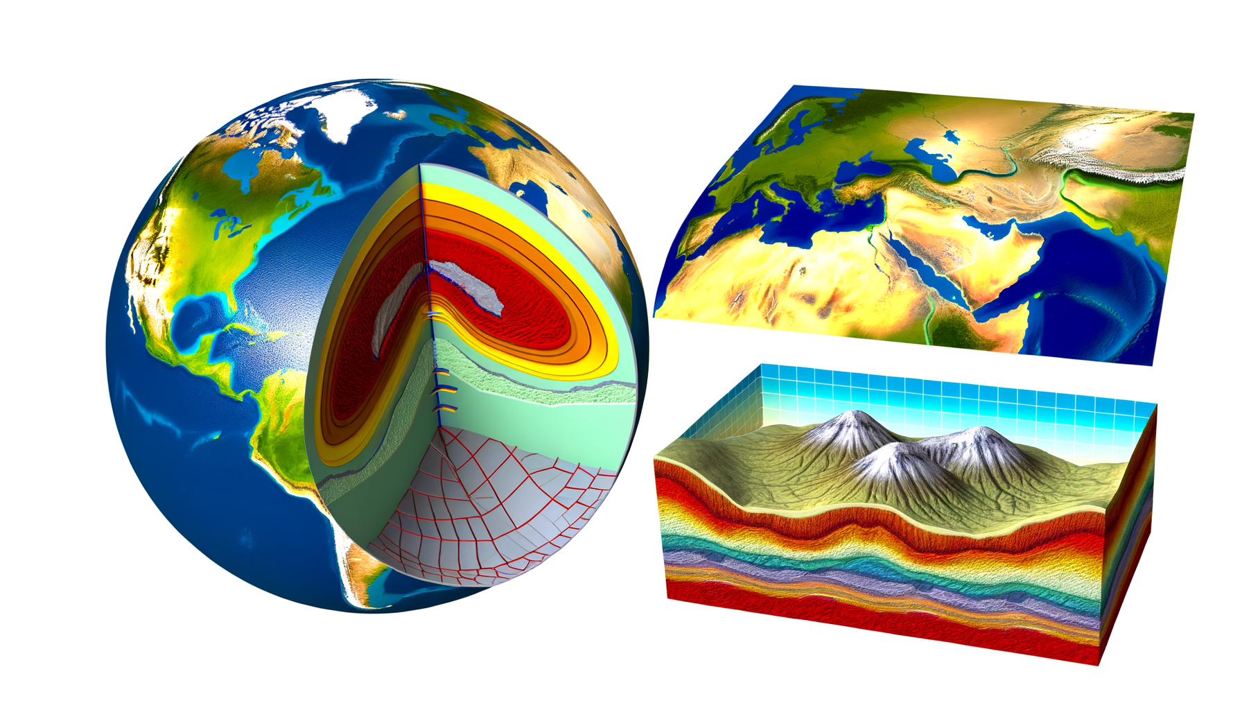
Our planet is not uniform throughout; it is structured like an onion, albeit a very complex and incredibly hot one, with distinct layers arranged concentrically.
These layers differ dramatically in their composition, temperature, pressure, and physical state, ranging from solid iron at the very center to the brittle, rocky crust we inhabit.
Geoscientists have pieced together this understanding not through direct drilling—as no drill can penetrate more than a tiny fraction of the way down—but through indirect methods, primarily the study of seismic waves generated by earthquakes, which travel through the Earth and change speed and direction as they encounter different materials and states.
Each boundary between these layers represents a significant change in physical properties, marking transitions crucial to the planet's overall behavior and energy transfer.
The Innermost Realm: Earth's Core
At the very heart of our planet lies the core, a region of immense heat and pressure that plays a vital role in generating Earth's magnetic field.
Composed primarily of iron and nickel, the core is divided into two distinct parts: a solid inner core and a liquid outer core.
Despite its extreme depth, understanding the core is essential because its dynamics profoundly affect the entire planet, from protecting us with its magnetic field to influencing the flow of heat that drives processes in the layers above.
The Solid Inner Core
The inner core is Earth's deepest layer, a sphere with a radius of about 1,220 kilometers (approximately 760 miles).
Despite temperatures estimated to be between 5,200 and 6,000 degrees Celsius (roughly 9,400 to 10,800 degrees Fahrenheit), comparable to the surface of the Sun, the inner core remains solid.
This incredible solidity is due to the unimaginable pressure at that depth, estimated to be about 3.6 million times the pressure at sea level, which forces the iron and nickel atoms into a rigid crystalline structure, preventing them from melting.
The inner core is slowly growing over geological time as the liquid outer core cools and solidifies onto its surface.
Studies of seismic waves passing through the inner core suggest that it may have a complex structure, possibly with different regions or even a super-rotation relative to the rest of the planet, though this is an area of ongoing scientific research and debate.
Its presence acts as the anchoring point around which the liquid outer core flows, a critical factor in the generation of the magnetic field.
The Liquid Outer Core
Surrounding the inner core is the outer core, a vast layer about 2,260 kilometers (approximately 1,400 miles) thick.
Unlike the inner core, the outer core is entirely liquid, composed mainly of molten iron and nickel, along with lighter elements like sulfur, oxygen, silicon, or carbon.
Temperatures in the outer core range from about 4,400 to 6,100 degrees Celsius (roughly 7,950 to 11,000 degrees Fahrenheit), hotter towards the boundary with the inner core and cooler towards the mantle.
The most significant role of the outer core is the generation of Earth's magnetic field through a process called the geodynamo.
Convection currents within the electrically conductive liquid iron, driven by heat flowing from the inner core and gravitational stirring as lighter elements separate, create electrical currents.
These electrical currents, in turn, generate a magnetic field that extends far out into space, forming the magnetosphere, which protects our planet from harmful solar wind and cosmic radiation, making life on the surface possible.
The Great Mediator: Earth's Mantle
Above the core lies the mantle, the largest layer of Earth by volume, extending from the core-mantle boundary up to the base of the crust.
This colossal shell is about 2,900 kilometers (approximately 1,800 miles) thick and makes up about 84 percent of Earth's volume.
The mantle is predominantly composed of silicate rocks rich in iron and magnesium, denser than the rocks found in the crust.
While often described as solid, the mantle is not rigidly static; it is a region undergoing extremely slow deformation and flow over geological timescales due to the intense heat and pressure.
This gradual movement, particularly in the upper parts of the mantle, is the primary driving force behind plate tectonics, the process that shapes Earth's surface.
The mantle is generally divided into the lower mantle and the upper mantle, with a significant transition zone in between.
The Lower Mantle
The lower mantle, extending from the core-mantle boundary up to about 660 kilometers (410 miles) below the surface, is the deepest and most voluminous part of the mantle.
Pressures here are immense, causing the silicate minerals to exist in highly compressed, dense forms, even at high temperatures.
Although solid under these extreme conditions, the lower mantle still participates in the slow convective flow that transfers heat from the core towards the surface, albeit potentially at slower rates than the upper mantle.
The Upper Mantle
The upper mantle extends from the base of the crust down to about 660 kilometers (410 miles) depth.
This region is crucial for understanding plate tectonics as it includes the asthenosphere and the lowermost part of the lithosphere.
Temperatures decrease with decreasing depth, but pressure also decreases significantly compared to the lower mantle, influencing the physical state of the rocks.
The Asthenosphere: The "Plastic" Layer
Within the upper mantle, generally located between about 100 and 410 kilometers (62 and 255 miles) depth, is the asthenosphere.
This layer is particularly important because, while still largely solid, the rocks here are close to their melting point and are considerably less rigid and more ductile or "plastic" than the rock above or below it.
Think of it like very thick, slow-moving asphalt or taffy over geological time.
The asthenosphere's ability to flow, albeit slowly, allows the rigid lithospheric plates above it to move and slide.
This ductile layer acts as a critical decoupling zone, enabling the movement that causes earthquakes, volcanoes, and mountain building on the surface.
Understanding the asthenosphere's properties is key to understanding how the surface of our planet constantly changes.
Mantle Convection: The Engine of Plate Tectonics
The immense heat from the core and radioactive decay within the mantle drives a process called mantle convection.
Hotter, less dense rock from deeper parts of the mantle slowly rises, while cooler, denser rock near the surface sinks.
This slow, churning motion within the mantle provides the primary force that drags and pushes the lithospheric plates across Earth's surface.
These convective cells within the mantle transfer heat outwards, a fundamental process in Earth's thermal evolution.
The boundaries where these convective currents meet and diverge directly influence the behavior of the tectonic plates above.
Understanding mantle convection is therefore crucial for comprehending how continents move, oceans open and close, and mountains rise.
The Surface Skin: Earth's Crust
The outermost and thinnest layer of Earth is the crust, the rocky shell that forms the continents and ocean basins we live on.
While it is the most accessible layer for direct study, its average thickness is only about 5 to 70 kilometers (about 3 to 43 miles), a tiny fraction compared to the mantle or core.
Despite its thinness, the crust is incredibly important as it hosts all known life and contains the resources we depend upon.
The crust is composed of a variety of igneous, metamorphic, and sedimentary rocks, which are significantly less dense than the rocks of the mantle.
This difference in density causes the crust to "float" on the denser mantle beneath it, a concept related to isostasy.
There are two fundamentally different types of crust, each with distinct characteristics.
Continental Crust
Continental crust forms the landmasses and is generally much thicker than oceanic crust, ranging from about 30 to 70 kilometers (18 to 43 miles) in thickness.
It is primarily composed of rocks with a granitic composition, which are rich in silica and aluminum and relatively low in density.
Continental crust is also significantly older than oceanic crust, with some parts dating back billions of years, preserving a long history of geological activity.
Because it is thick and relatively light, continental crust tends to rise higher and does not easily subduct (sink) back into the mantle.
This characteristic explains why continents persist over vast timescales and why they can form massive mountain ranges when they collide.
The variation in thickness and composition of continental crust contributes directly to the varied topography we see on land.
Oceanic Crust
Oceanic crust underlies the ocean basins and is much thinner and denser than continental crust, typically ranging from about 5 to 10 kilometers (3 to 6 miles) thick.
It is composed mainly of basaltic rocks, which are richer in iron and magnesium and less silica-rich than granitic rocks.
Oceanic crust is also geologically much younger than continental crust, with the oldest parts being only about 200 million years old, as it is constantly being created at mid-ocean ridges and destroyed at subduction zones.
Because it is thinner and denser, oceanic crust sits lower than continental crust, forming the ocean basins where water accumulates.
Its formation and destruction are integral parts of the plate tectonic cycle, linking surface features like ocean trenches and volcanic island arcs directly to processes happening within the lithosphere and mantle.
The contrast between the buoyancy and age of continental and oceanic crust is a key driver of global topography.
The Rigid Shell: Earth's Lithosphere
The lithosphere is not one of the primary compositional layers like the crust or mantle, but rather a mechanical layer defined by its rigidity.
It consists of the entire crust plus the uppermost, rigid part of the upper mantle.
The lithosphere varies in thickness, being thinner under oceanic crust (about 50-100 km or 30-60 miles) and thicker under continental crust (up to 150-200 km or 90-120 miles or even more under mountain ranges).
This rigid layer is broken into large and small pieces called tectonic plates.
These plates "float" and move slowly over the more ductile asthenosphere beneath them.
The interactions of these moving plates at their boundaries are responsible for most of Earth's major geological phenomena.
Plate Tectonics - The Lithosphere in Motion
The theory of plate tectonics is one of the most unifying concepts in Earth science, explaining how the movement of the lithospheric plates shapes the planet's surface.
Driven by the convective currents in the mantle, these plates converge, diverge, and slide past each other at rates of a few centimeters per year.
These interactions manifest on the surface as dramatic geological features and events.
At divergent boundaries, like mid-ocean ridges, new oceanic lithosphere is created as mantle material rises and solidifies.
At convergent boundaries, plates collide; if oceanic and continental lithosphere meet, the denser oceanic plate typically subducts beneath the continental plate, leading to volcanic mountains and deep ocean trenches.
If two continental plates collide, neither subducts easily, resulting in the formation of vast mountain ranges like the Himalayas.
Transform boundaries are where plates slide horizontally past each other, often causing frequent earthquakes, such as along the San Andreas Fault in California.
All these surface expressions are direct consequences of the movement and interaction of the lithosphere, powered by the deeper mantle.
Understanding the lithosphere's structure and behavior is key to interpreting the surface landscape.
Connecting Internal Structure to Surface Features
It is easy to view Earth's layers as abstract concepts separate from the world we see.
However, the dynamic processes occurring within the core, mantle, and lithosphere are intricately linked to the topography and geological activity on the surface.
The mountains, valleys, plains, and ocean depths that define Earth's relief are ultimately shaped by forces originating deep inside the planet.
How Internal Processes Shape Topography
Mantle convection provides the energy that moves tectonic plates.
Where plates diverge, rifting occurs, leading to valleys (like the East African Rift Valley) or the formation of new ocean basins.
Where plates converge, uplift and mountain building happen (e.g., the Andes formed by oceanic-continental convergence, the Alps by continental-continental collision).
Subduction zones create deep ocean trenches, the lowest points on Earth's surface.
Volcanic activity, often associated with divergent and convergent boundaries (especially subduction zones), builds mountains and plateaus with erupted material.<
Earthquakes, caused by the sudden release of stress accumulated as plates move, can also alter the landscape.
Even seemingly stable continental interiors are under stress from plate movements, which can reactivate ancient fault lines and influence regional elevations over geological time.
The Influence of Crustal Thickness and Type
The fundamental difference between thick, buoyant continental crust and thin, dense oceanic crust is a primary control on global topography.
Continental crust floats higher on the mantle, forming continents, while oceanic crust sits lower, forming ocean basins.
Variations in continental crust thickness, often caused by mountain building, directly lead to higher elevations.
This principle, known as isostasy, explains why thick mountain belts have deep "roots" extending down into the mantle.
The composition of the crust also influences erosion and weathering patterns, which sculpt the finer details of the landscape over time.
However, the large-scale features—the placement of mountain ranges, the vast ocean trenches, the location of volcanic chains—are direct consequences of the deeper layers' dynamics and the behavior of the lithospheric plates.
This direct link between the invisible internal structure and the visible surface is profound.
Visualizing Earth's Layers with Relief Maps
Understanding the abstract concepts of Earth's layers, their properties, and their interactions can be challenging, especially when trying to grasp their immense scale and depth.
We cannot simply look inside the Earth.
This is where visualization tools, and specifically relief maps, become incredibly powerful educational and explanatory aids.
Relief maps, whether physical models with raised topography or digital representations using color and shading, depict the elevation and depth of Earth's surface.
They show mountains, valleys, plateaus, plains, and underwater features like seamounts and ocean trenches.
While a relief map doesn't directly show the core, mantle, or crust as separate layers, it vividly displays the *results* of the processes driven by these internal layers and their interactions.
Bridging the Abstract and the Visible
Relief maps provide a tangible link between the invisible internal Earth and the visible external landscape.
By showing where mountains are located, where deep ocean trenches lie, and the extent of vast plains, relief maps illustrate the consequences of plate tectonic activity.
For example, tracing the line of the Andes Mountains on a relief map visually corresponds to understanding the convergent boundary where the Nazca plate subducts beneath the South American plate – a process driven by mantle convection and involving the properties of both oceanic and continental lithosphere.
Similarly, the mid-Atlantic Ridge, visible as a raised feature on an ocean floor relief map, represents a divergent boundary where new oceanic crust is being created from rising mantle material.
Relief maps allow us to see the *pattern* of surface features that is directly dictated by the movements of the lithospheric plates.
They turn the theoretical model of plate tectonics into a visible reality on the landscape.
Representing Different Thicknesses (Indirectly)
While a relief map doesn't show the thickness of the mantle or core, it *does* show the varying elevation of the surface, which is a direct consequence of the varying thickness and buoyancy of the crust and lithosphere.
Higher elevations on continents correspond to thicker continental crust that floats higher on the mantle.
Lower elevations and ocean basins correspond to thinner oceanic crust (and lithosphere) that sits lower.
Relief maps thus provide a visual representation of the principle of isostasy, demonstrating how the thickness and density of the outermost layers affect their vertical position relative to the mantle.
Illustrating Plate Tectonic Activity
Perhaps the most powerful way relief maps help visualize the impact of Earth's layers is by clearly displaying the major features created by plate tectonics.
• Mountain Ranges: Show where continental plates have collided or where oceanic plates have subducted, pushing up crustal material.
• Ocean Trenches: Mark the locations of subduction zones, where old, dense oceanic lithosphere returns to the mantle.
• Mid-Ocean Ridges: Highlight where new oceanic lithosphere is forming as mantle material rises.
• Volcanic Arcs and Chains: Often parallel trenches or follow rift zones, showing where molten rock from the mantle reaches the surface.
By examining the patterns on a relief map, one can infer the types of plate boundaries present and, by extension, understand the underlying interactions of the lithosphere and the convective forces within the mantle driving them.
It makes the abstract concept of plate movement tangible and observable on the surface landscape.
Making Learning Engaging and Accessible
For students and anyone new to geology, the deep Earth layers can seem abstract and remote.
Relief maps, especially physical, tactile models, make the concepts more concrete and engaging.
You can literally feel the mountains and see the depths of the oceans, connecting these visible features to the powerful, unseen forces within the Earth.
They provide a user-friendly way to explore the major geological provinces shaped by the Earth's internal heat engine.
Using relief maps alongside cross-section diagrams of Earth's layers provides a powerful combination for building a comprehensive understanding of our planet's structure and dynamics.
Conclusion: The Interconnected Earth
Our journey to the center of the Earth reveals a complex, dynamic system of interconnected layers.
From the superheated, high-pressure core generating our protective magnetic field to the vast, slowly churning mantle driving the movement of tectonic plates, and finally to the thin, life-bearing crust that forms our landscape, each layer plays a critical role in the planet's function.
The interaction between these layers, particularly the convective flow in the mantle and the movement of the rigid lithospheric plates above it, is the fundamental engine that shapes the surface topography we see.
The mountains we climb, the valleys we explore, the oceans we sail – all are sculpted by forces originating thousands of kilometers beneath our feet.
Visualizing these connections can be difficult, but relief maps offer a powerful bridge, allowing us to see and understand the surface expressions of these deep, unseen processes.
They transform abstract geological concepts into tangible landscapes, revealing the profound relationship between Earth's inner layers and the diverse, ever-changing world above.
Exploring a relief map is not just looking at surface elevations; it is witnessing the culmination of billions of years of internal planetary dynamics made visible.
Take a moment to study a relief map of your region or the world, and see if you can identify features that reveal the story of Earth's dynamic inner layers at work.